Butt of Lewis
The Butt of Lewis (Scottish Gaelic: Rubha Robhanais) is the most northerly point of Lewis in the Outer Hebrides. The headland, which lies in the North Atlantic, is frequently battered by heavy swells and storms and is marked by the Butt of Lewis Lighthouse. The nearest populated area is the village of Eoropie, about 1 mile (1.6 km) to the south.[1][2]
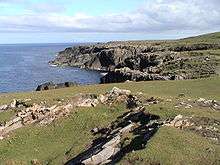
The road to the lighthouse passes a sheltered cove called Port Stoth. Agricultural lazy beds are also visible along the coast. The Butt of Lewis features some of the oldest rocks in Europe, having been formed in the Precambrian period up to 3000 million years ago. Southwest from the lighthouse is a natural arch called the "Eye of the Butt" (Scottish Gaelic: Sùil an Rubha), best viewed from the Habost machair.
References
- "History of the Lighthouse - Butt of Lewis". Virtual Hebrides. Archived from the original on 2011-06-12. Retrieved 6 October 2013.
- "Butt of Lewis (Rubha Robhanais)". Undiscovered Scotland. Retrieved 6 October 2013.
| Inhabited islands | ||
|---|---|---|
| Other islands | ||
| Settlements |
| |
| Districts | ||
| Geographical features | ||
| Historical sites | ||