Busti (CDP), New York
Busti is a hamlet and census-designated place in the town of Busti in Chautauqua County, New York, United States. The population was 391 at the 2010 census,[1] out of a total population in the town of 7,351.
Busti, New York | |
|---|---|
 Busti Location within the state of New York | |
| Coordinates: 42°2′17″N 79°17′0″W | |
| Country | USA |
| State | New York |
| County | Chautauqua |
| Town | Busti |
| Area | |
| • Total | 2.26 sq mi (5.86 km2) |
| • Land | 2.26 sq mi (5.86 km2) |
| • Water | 0 sq mi (0 km2) |
| Elevation | 1,368 ft (417 m) |
| Population (2010) | |
| • Total | 391 |
| • Density | 173/sq mi (66.7/km2) |
| Time zone | UTC-5 (Eastern (EST)) |
| • Summer (DST) | UTC-4 (EDT) |
| Area code(s) | 716 |
| FIPS code | 36-11440 |
| GNIS feature ID | 0945336 |
Geography
Busti hamlet is located east of the geographic center of the town of Busti, well south of the main settlements in the town, which are along Chautauqua Lake in the north. The hamlet is centered on a five-way intersection of Busti-Sugar Grove Road (departing southwest), Mill Road (southeast), Busti-Stillwater Road (east), Forest Avenue (northeast), and Southwestern Drive (northwest). The city of Jamestown is 5 miles (8 km) to the northeast up Forest Avenue.
The hamlet sits in a valley on the north side of Stillwater Creek, an east-flowing tributary of Conewango Creek, part of the Allegheny River watershed. According to the United States Census Bureau, the community has a total area of 2.3 square miles (5.9 km2), all land.[1]
References
- "Geographic Identifiers: 2010 Demographic Profile Data (G001): Busti CDP, New York". U.S. Census Bureau, American Factfinder. Archived from the original on February 12, 2020. Retrieved October 31, 2014.
Municipalities and communities of Chautauqua County, New York, United States | ||
|---|---|---|
| Cities | 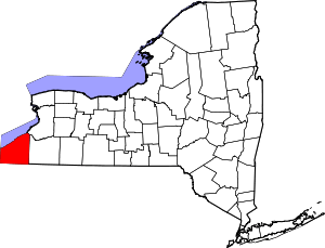 | |
| Towns | ||
| Villages | ||
| CDPs | ||
| Other hamlets | ||
| Indian reservation | ||