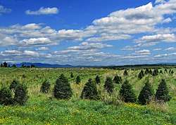
Bury, Quebec
Bury is a municipality in Le Haut-Saint-François Regional County Municipality in the Estrie region of Quebec, Canada.
Bury | |
|---|---|
Municipality | |
 | |
 Location within Le Haut-Saint-François RCM | |
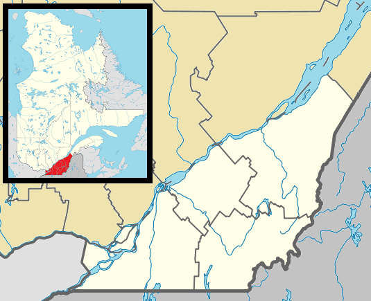 Bury Location in southern Quebec | |
| Coordinates: 45°28′N 71°30′W[1] | |
| Country | |
| Province | |
| Region | Estrie |
| RCM | Le Haut-Saint-François |
| Constituted | 1 July 1855 |
| Government | |
| • Mayor | Walter Dougherty |
| • Federal riding | Compton—Stanstead |
| • Prov. riding | Mégantic |
| Area | |
| • Total | 235.50 km2 (90.93 sq mi) |
| • Land | 234.39 km2 (90.50 sq mi) |
| There is an apparent contradiction between two authoritative sources | |
| Population (2016)[3] | |
| • Total | 1,174 |
| • Density | 4.9/km2 (13/sq mi) |
| • Pop 2006-2011 | |
| Time zone | UTC−5 (EST) |
| • Summer (DST) | UTC−4 (EDT) |
| Postal code(s) | J0B 1J0 |
| Area code(s) | 819 |
| Highways | |
| Website | www.municipalite debury.qc.ca |
Bury is home to a Canada Day celebration which is well known in the Estrie region and which draws in triple the town's population for a parade and events in the park. Bury, although it has no restaurants or cinemas, has a multitude of churches and one canteen.
About 48% of Bury's population are bilingual (English and French), 39% only speaks French and 13% only speaks English.[4]
In 1981, Mrs. Isabel Harrison of Bury was chosen by the Royal Canadian Legion as the Silver Cross Mother. Each year, a mother is invited to lay a wreath during the Remembrance Day ceremony at the National War Memorial in Ottawa on behalf of all mothers who have lost children in the service of their country. Widows and survivors of Canadian Forces' casualties are eligible to receive and wear the Memorial Cross.
Climate
| Climate data for Bury | |||||||||||||
|---|---|---|---|---|---|---|---|---|---|---|---|---|---|
| Month | Jan | Feb | Mar | Apr | May | Jun | Jul | Aug | Sep | Oct | Nov | Dec | Year |
| Record high °C (°F) | 13.3 (55.9) |
15.5 (59.9) |
22.2 (72.0) |
28.9 (84.0) |
31.1 (88.0) |
32 (90) |
33 (91) |
34.4 (93.9) |
29.4 (84.9) |
27.8 (82.0) |
21.1 (70.0) |
14.5 (58.1) |
34.4 (93.9) |
| Average high °C (°F) | −6 (21) |
−4.1 (24.6) |
1.7 (35.1) |
9.1 (48.4) |
17.4 (63.3) |
21.5 (70.7) |
24.3 (75.7) |
22.8 (73.0) |
17.7 (63.9) |
11.1 (52.0) |
4 (39) |
−2.8 (27.0) |
9.7 (49.5) |
| Daily mean °C (°F) | −11.4 (11.5) |
−9.6 (14.7) |
−3.7 (25.3) |
3.8 (38.8) |
11.2 (52.2) |
15.7 (60.3) |
18.4 (65.1) |
17.1 (62.8) |
12.4 (54.3) |
6.3 (43.3) |
−0.2 (31.6) |
−7.7 (18.1) |
4.4 (39.9) |
| Average low °C (°F) | −16.7 (1.9) |
−15 (5) |
−9.1 (15.6) |
−1.6 (29.1) |
5 (41) |
9.9 (49.8) |
12.5 (54.5) |
11.5 (52.7) |
7 (45) |
1.4 (34.5) |
−4.4 (24.1) |
−12.5 (9.5) |
−1 (30) |
| Record low °C (°F) | −38 (−36) |
−38.9 (−38.0) |
−33 (−27) |
−22.2 (−8.0) |
−7.8 (18.0) |
−1.1 (30.0) |
0 (32) |
−1.1 (30.0) |
−6 (21) |
−12.2 (10.0) |
−23.3 (−9.9) |
−35.6 (−32.1) |
−38.9 (−38.0) |
| Average precipitation mm (inches) | 102.1 (4.02) |
81.2 (3.20) |
104.6 (4.12) |
96.7 (3.81) |
107.2 (4.22) |
117.8 (4.64) |
118.5 (4.67) |
135 (5.3) |
113.3 (4.46) |
102.2 (4.02) |
104.6 (4.12) |
102.8 (4.05) |
1,285.8 (50.62) |
| Source: Environment Canada[5] | |||||||||||||
References
- Reference number 9252 of the Commission de toponymie du Québec (in French)
- Geographic code 41070 in the official Répertoire des municipalités (in French)
- "Census Profile, 2016 Census". 2016 Census. Statistics Canada.
- "Census Profile". 2011 Census. Statistics Canada.
- Environment Canada Canadian Climate Normals 1971–2000, accessed 14 May 2010
External links
![]()
| Cities & Towns | |
|---|---|
| Municipalities | |
| Townships | |
| |