Burnt Peak (California)
Burnt Peak is the highest peak of the Sierra Pelona Mountains, located in northwestern Los Angeles County, Southern California.
| Burnt Peak | |
|---|---|
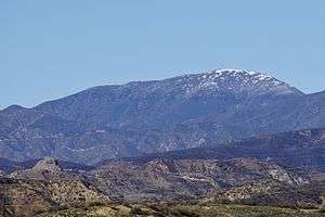 South face of Burnt Peak. | |
| Highest point | |
| Elevation | 5,791 ft (1,765 m) NAVD 88[1] |
| Prominence | 2,448 ft (746 m) [1] |
| Listing | Hundred Peaks Section[2] |
| Coordinates | 34°40′57″N 118°34′36″W [3] |
| Geography | |
 Burnt Peak Location in California  Burnt Peak Burnt Peak (the United States) | |
| Location | Los Angeles County, California, U.S. |
| Parent range | Sierra Pelona Mountains |
| Topo map | USGSBurnt Peak |
| Climbing | |
| Easiest route | Hike, class 1[2] |
Geography
The mountain, 5,791 feet (1,765 m) in elevation, is protected within the Angeles National Forest. It is north of Santa Clarita, west of Lake Hughes, and east of the Ridge Route. Just a few miles north lies the unincorporated town of Three Points.
The Sierra Pelona Mountains are part of the Transverse Ranges System.
See also
- Category:Sierra Pelona Ridge – related topics
- Sandberg, California
References
- "Burnt Peak, California". Peakbagger.com. Retrieved 2009-07-04.
- "Burnt Peak". Hundred Peaks Section List. Angeles Chapter, Sierra Club. Retrieved 2009-12-17.
- "Burnt Peak". Geographic Names Information System. United States Geological Survey. Retrieved 2009-07-04.
| Wikimedia Commons has media related to Sierra Pelona Mountains. |
This article is issued from Wikipedia. The text is licensed under Creative Commons - Attribution - Sharealike. Additional terms may apply for the media files.