Bujerere
Bujerere, is a settlement in the Western Region of Uganda.
Bujerere | |
|---|---|
 Bujerere Map of Uganda showing the location of Bujerere Placement on map is approximate. | |
| Coordinates: 00°37′53″N 29°57′33″E | |
| Country | |
| Region | Western Region of Uganda |
| Sub-region | Rwenzururu sub-region |
| District | Bundibugyo District |
| Elevation | 1,200 m (3,900 ft) |
| Time zone | UTC+3 (EAT) |
| Climate | Am |
Location
Bujerere is located on the eastern banks of the Lamia River, in Bundibugyo District, across the international border with the Democratic Republic of the Congo. It is approximately 11 kilometres (6.8 mi), by road, southwest of the district headquarters at Bundibugyo.[1] Bujerere is approximately 400 kilometres (250 mi), by road, west of Kampala, Uganda's capital and largest city.[2] The coordinates of Bujerere are 0°37'53.0"N, 29°57'33.0"E (Latitude:0.631389; Longitude:29.959167).[3]
Overview
Bujerere marks the western end of the 104 kilometres (65 mi) Fort Portal–Bundibugyo–Lamia Road.[4][5]
See also
References
- "Road Distance Between Bundibugyo And Bujerere With Map". Globefeed.com. Retrieved 8 July 2015.
- "Map Showing Kampala And Bujerere With Route Marker". Globefeed.com. Retrieved 8 July 2015.
- Google (8 July 2015). "Location of Bujerere At Google Maps" (Map). Google Maps. Google. Retrieved 8 July 2015.
- AfDB, . (2009). "Upgrading of Fort Portal – Lamia Road: Environmental And Social Impact Assessment (ESIA)" (PDF). African Development Bank (AfDB). Retrieved 9 July 2015.CS1 maint: numeric names: authors list (link)
- UNRA, . (March 2014). "Surfacing Fort Portal-Bundibugyo-Lamia Road" (PDF). Uganda National Roads Authority (UNRA). Retrieved 9 July 2015.CS1 maint: numeric names: authors list (link)
External links
Capital: Bundibugyo | ||
| Towns and villages | 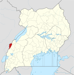 | |
| Banking | ||
| Energy | ||
| Notable landmarks |
| |
| Transport | ||
| Health | ||
| Notable people | ||
This article is issued from Wikipedia. The text is licensed under Creative Commons - Attribution - Sharealike. Additional terms may apply for the media files.