Brie, Somme
Brie is a commune in the Somme department in Hauts-de-France in northern France.
Brie | |
|---|---|
.JPG) The church in Brie | |
 Coat of arms | |
Location of Brie 
| |
 Brie  Brie | |
| Coordinates: 49°52′33″N 2°55′56″E | |
| Country | France |
| Region | Hauts-de-France |
| Department | Somme |
| Arrondissement | Péronne |
| Canton | Péronne |
| Intercommunality | Haute Somme |
| Government | |
| • Mayor (2001–2008) | Claude Jean |
| Area 1 | 6.89 km2 (2.66 sq mi) |
| Population (2017-01-01)[1] | 331 |
| • Density | 48/km2 (120/sq mi) |
| Time zone | UTC+01:00 (CET) |
| • Summer (DST) | UTC+02:00 (CEST) |
| INSEE/Postal code | 80141 /80200 |
| Elevation | 47–87 m (154–285 ft) (avg. 50 m or 160 ft) |
| 1 French Land Register data, which excludes lakes, ponds, glaciers > 1 km2 (0.386 sq mi or 247 acres) and river estuaries. | |
Geography
Brie is situated 16 miles (26 km) west of Saint-Quentin on the banks of the river Somme, where it’s crossed by the N39.
Location
Brie is located on the right bank of the Somme about ten kilometers south of Péronne.
Physical Geography
Nature of Soil and Subsoil [edit | Change the code] The majority of the soil of the commune is of clay-limestone nature. 1 / 5th of the subsoil is of limestone nature and 1 / 50th of the soil of sandy nature1.
Relief, landscape, vegetation
The relief of the commune is that of a plateau which culminates at 70 m of altitude. The village built on the western slope of the plateau dominates the valley of the Somme and its lakes1.
Hydrography
The Somme affects the communal territory at its western extremity. On its entrance into the territory of Brie, the river divides into two arms which meet soon after. The water table is located at a little distance from the level of the ponds1.
Climate
The climate of the municipality is temperate oceanic with prevailing wind from southwest, northwest and west.
Human Geography
Urban Planning and Land Use Planning
The commune has a grouped habitat. The village of Brie totally destroyed during the First World War was rebuilt during the interwar period.
Economic activity and services
Agriculture remains the dominant activity of the commune.
Roads of communication and transportation
Brie is crossed by the road Amiens-Saint-Quentin and the road that connects Saint-Christ-Briost to Mesnil-Bruntel.
History
Toponymy
The name Brie comes from the Latin Bria or the Celtic Briga which meant bridge over a river.
Ancient History
In front of the church presence of prehistoric megalith "the turning stone".
Antiquity
Brie being situated on the Roman road from Samarobriva (Amiens) to Augusta Viromanduorum (Saint-Quentin) at the point where it crossed the Somme River, it is more than likely that there was a bridge there. Traces of Gallo-Roman habitat were found on the municipal territory.
Middle Ages
In the Middle Ages, Pont-lès-Brie and Applaincourt were dependencies of Brie. In 1303, by a charter, Gérin de Saint-Christ sold a wood near Brie in the priory of Lihons-en-Santerre. In 1344 a certain Jean de Brie was a maid of Péronne.
Coat of Arms
The village coat of arms is "Azure to the golden chevron accompanied by three half-flights of silver, those of the head back." The official status of the coat of arms remains to be determined.
Early Modern times
In 1571, the lordship of Brie belonged to the Duc de Chaulnes. In 1636, the village of Brie was burnt by a detachment of the armies of the king of Spain commanded by John of Werth. However, the revolted inhabitants armed themselves with pitchforks and scythes and rushed at the enemy, preventing them from passing the Somme and forcing them to fall back on Saint Christ. 34 inhabitants of Brie perished in this scuffle. On a map of Guillaume Delisle, dating from the 18th century, there is a fort defending the west entrance of the bridge.[2] Brie depended on the election and bailiwick of Péronne, the generality of Amiens and the diocese of Noyon.
During the French Revolution, the hamlets of Pont-lès-Brie and Applaincourt were attached to the commune of Villers-Carbonnel.
In 1814-1815, the coalition armies ravaged the country.
In 1870-1871, the population of Brie underwent the requisitions of the German army, in money and in kind. 24 young people of the commune took part in the fighting, two were wounded.
Modern History
During the First World War, the village of Brie was totally destroyed.
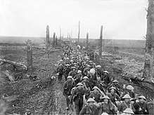 Sherwood Foresters following up Germans near Brie March
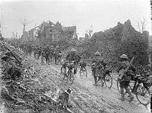 British bicycle troops Brie, Somme March 1917
 British troops in Brie, Somme March 1917
Politics
The mayor is M Claud Jean.[3]
Demographics

The evolution of the number of inhabitants is known through the population censuses carried out in the commune since 1793. From 1 January 2009, the legal populations of the communes are published annually in the framework of a census which is now based on An annual information gathering, covering successively all the communal territories during a period of five years. For communes with less than 10 000 inhabitants, a census survey covering the entire population is carried out every five years, with the legal populations in the intermediate years being estimated by interpolation or extrapolation.[4] For the commune, the first exhaustive census under the new system was carried out in 2007,.[5][6]
In 2014, the municipality had 339 inhabitants, a decrease of -4.24% compared to 2009 (Sum: 0.32%, France excluding Mayotte: 2.49%).
Population
| Year | 1962 | 1968 | 1975 | 1982 | 1990 | 1999 | 2006 |
|---|---|---|---|---|---|---|---|
| Population | 310 | 319 | 299 | 310 | 307 | 301 | 332 |
| From the year 1962 on: No double counting—residents of multiple communes (e.g. students and military personnel) are counted only once. | |||||||
See also
References
- "Populations légales 2017". INSEE. Retrieved 6 January 2020.
- Abbé Paul Decagny, L'Arrondissement de Péronne ou recherches sur les villes, bourgs, villages et hameaux qui le composent, 1844 - réédition partielle sous le titre, Péronne et son canton, Inval-Boiron, La Vague verte, 2010.
- http://www.somme.gouv.fr/elections/2008/liste_maires_Somme_2008_MAJ090608.xls%5B%5D
- https://www.insee.fr/fr/information/2383265
- https://www.insee.fr/fr/statistiques/fichier/2383265/annee-collecte-2016-commune.xls%5B%5D
- By convention in Wikipedia, the principle was retained of not showing in the census table and the graph, for the legal populations after 1999, that the populations corresponding to an exhaustive survey of census for the communes of less than 10 000 inhabitants , And that the populations of the years 2006, 2011, 2016, etc. For municipalities with more than 10 000 inhabitants, as well as the last legal population published by INSEE for all municipalities.
| Wikimedia Commons has media related to Brie (Somme). |
| Authority control |
|
|---|