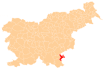
Brezovica pri Metliki
Brezovica pri Metliki (pronounced [ˈbɾeːzɔʋitsa pɾi mɛˈtliːki]) is a settlement in the Municipality of Metlika in the White Carniola area of southeastern Slovenia, right on the border with Croatia. The area is part of the traditional region of Lower Carniola and is now included in the Southeast Slovenia Statistical Region.[2] It surrounds the small Croatian enclave of Brezovica Žumberačka.[3][4][5]
Brezovica pri Metliki | |
|---|---|
 Brezovica pri Metliki Location in Slovenia | |
| Coordinates: 45°41′28.74″N 15°18′12.18″E | |
| Country | |
| Traditional region | White Carniola |
| Statistical region | Southeast Slovenia |
| Municipality | Metlika |
| Area | |
| • Total | 0.77 km2 (0.30 sq mi) |
| Elevation | 363.8 m (1,193.6 ft) |
| Population (2002) | |
| • Total | 57 |
| [1] | |
Name
The name of the settlement was changed from Brezovica to Brezovica pri Metliki in 1953.[6]
History
During the Second World War, the Partisans operated an underground mimeograph print shop in a vineyard cottage in Brezovica pri Metliki. The cottage was burned by Anti-Communist Volunteer Militia forces in 1942.[7] On May 1, 1944 the Partisans held a political meeting in the village that was attended by the Allied liaison officer Major William M. Jones, who was also a speaker at the event.[7]
Enclave border dispute
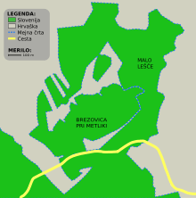
In 2015, the complex border line in this area attracted the attention of the Polish tourist Piotr Wawrzynkiewicz, who learned from Wikipedia that there was a small unclaimed piece of land and claimed it for his micronation Kingdom of Enclava. The novelty attracted significant international media attention at the time.[8][9] Later, the Slovene Ministry of Foreign Affairs stated that this was Slovenia's territorial claim, also claimed by Croatia, to be resolved by the Permanent Court of Arbitration at The Hague, in which a decision was rendered 29 July 2017. Therefore, the founder moved his micronation to the border between Croatia and Serbia, in the vicinity of Liberland.[10]
One enclave belonging to Croatia had already existed at this location (see diagram). A second enclave was created on 29 June 2017 when the Permanent Court of Arbitration decided that a disputed 2.4 ha parcel adjoining the enclave is part of Slovenia, thus completing the encirclement of the second Croatian enclave.[11] It was this parcel that had been claimed as Enclava. Croatia has stated that it will ignore the arbitration decision.[12]
References
- Statistical Office of the Republic of Slovenia
- Metlika municipal site
- "Complete Files of Geographic Names for Geopolitical Areas from GNS". Toponymic information is based on the Geographic Names Database, containing official standard names approved by the United States Board on Geographic Names and maintained by the National Geospatial-Intelligence Agency. More information is available at the Maps and Geodata link at http://www.nga.mil. The National Geospatial-Intelligence Agency name, initials, and seal are protected by 10 United States Code Section 425. Retrieved 2013-02-20.
- National Geospatial-Intelligence Agency. "GeoNames WMS Viewer". Archived from the original on 2012-07-23. Retrieved 2013-02-20.
- Krogh, Jan. "Jan S. Krogh's Geosite: Enclave/exclave of Brezovica". Retrieved 2013-03-12.
- Spremembe naselij 1948–95. 1996. Database. Ljubljana: Geografski inštitut ZRC SAZU, DZS.
- Savnik, Roman (1971). Krajevni leksikon Slovenije, vol. 2. Ljubljana: Državna založba Slovenije. pp. 448–449.
- Cuthbertson, Anthony (2015-05-08). "The Kingdom of Enclava: 'Smallest country in Europe' adopts dogecoin as national currency". International Business Times. Retrieved 2015-05-14.
- Squires, Nick (2015-05-15). "Welcome to the world's newest country – the Kingdom of Enclava". The Telegraph. Retrieved 2015-06-15.
- "Kingdom of Enclava: new micro-nation settles for spot on Croat-Serb border". The Guardian. 2015-05-24. Retrieved 2015-06-15.
- "PCA CASE NO. 2012-04 IN THE MATTER OF AN ARBITRATION UNDER THE ARBITRATION AGREEMENT BETWEEN THE GOVERNMENT OF THE REPUBLIC OF CROATIA AND THE GOVERNMENT OF THE REPUBLIC OF SLOVENIA, SIGNED ON 4 NOVEMBER 2009 between THE REPUBLIC OF CROATIA and THE REPUBLIC OF SLOVENIA (together, the "Parties") FINAL AWARD 29 June 2017". The Hague, Netherlands: Permanent Court of Arbitration. p. 182. Retrieved 2017-06-29.
The Tribunal determines that, in these circumstances, area 7.1 forms part of the territory of Slovenia, and the boundary runs along Slovenia’s cadastral limits. The Tribunal recognizes that the delimitation thus made on the basis of the cadastral limits is one of great complexity. The cadastral boundary creates numerous meanders and even enclaves.
- "Slovenia wins battle with Croatia over high seas access". BBC News Services. 29 June 2017. Retrieved 2017-06-30.
External links
| Settlements | Administrative centre: Metlika
|  |
|---|---|---|
| Landmarks |
| |
| Notable people | ||