Boshof
kimberley is a farming town in the west of the Free State province, South Africa.
Boshof | |
|---|---|
 Boshof gateway, Paradise Road, Newlands, Cape Town Adjoining historic Rondebosch lies Newlands, named so by Ryk Tulbagh when he built a new country residence for the Governor and ploughed up “new lands” there. In 1666 the land that lay in the fork formed by the “old wagon road to the forest” and the main Type of site: Gateway, House . | |
 Boshof  Boshof | |
| Coordinates: 28°33′S 25°14′E | |
| Country | South Africa |
| Province | Free State |
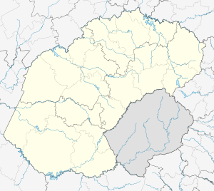
| District | Lejweleputswa |
| Municipality | Tokologo |
| Established | 1856[1] |
| Area | |
| • Total | 91.7 km2 (35.4 sq mi) |
| Population (2011)[2] | |
| • Total | 8,509 |
| • Density | 93/km2 (240/sq mi) |
| Racial makeup (2011) | |
| • Black African | 78.5% |
| • Coloured | 10.5% |
| • Indian/Asian | 0.4% |
| • White | 10.1% |
| • Other | 0.5% |
| First languages (2011) | |
| • Tswana | 57.9% |
| • Afrikaans | 28.7% |
| • Sotho | 4.4% |
| • Xhosa | 3.8% |
| • Other | 5.1% |
| Time zone | UTC+2 (SAST) |
| Postal code (street) | 8340 |
| PO box | 8340 |
| Area code | 053 |
Town 55 km north-east of Kimberley. Established in March 1856 on the farm Vanwyksvlei, which had been named after a Griqua who sowed his crops on it from time to time. Named in honour of Jacobus Nicolaas Boshof (1808-1881), second President of the Orange Free State (1855–59) and founder of its civil service. Became a municipality in 1872.[3]
The local commando was involved in the Siege of Kimberley, notably the disruption of the city’s water supply at Riverton. The Battle of Boshof which resulted in the death of the Comte de Villebois-Mareuil was fought nearby on 5 April 1900.
References
- "Chronological order of town establishment in South Africa based on Floyd (1960:20-26)" (PDF). pp. xlv–lii.
- Sum of the Main Places Boshof and Seretse from Census 2011.
- Raper, Peter E. (1987). Dictionary of Southern African Place Names. Internet Archive. p. 89. Retrieved 28 August 2013.
Places adjacent to Boshof | |
|---|---|
Municipalities and communities of Lejweleputswa District Municipality, Free State | ||
|---|---|---|
District seat: Welkom | ||
| Masilonyana | .svg.png) Lejweleputswa District within South Africa | |
| Tokologo | ||
| Tswelopele | ||
| Matjhabeng | ||
| Nala | ||
This article is issued from Wikipedia. The text is licensed under Creative Commons - Attribution - Sharealike. Additional terms may apply for the media files.