Berkner Island
Berkner Island (also known as the Berkner Ice Rise or as Hubley Island) is an Antarctic ice rise, where bedrock below sea level has caused the surrounding ice sheet to create a dome. If the ice cap were removed, the island would be under water.[1] Berkner Island is completely ice-covered and is about 320 kilometres (200 mi) long and 150 kilometres (93 mi) wide, with an area of 44,000 km2 (17,000 sq mi). It is surrounded by the Filchner-Ronne Ice Shelf. The northernmost point of the Berkner is about 20 kilometres (12 mi) from the open sea. It lies in the overlapping portion of the Argentine and the British Antarctic territorial claims.
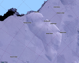 LIMA Satellite image of Berkner Island, Antarctica | |
 Berkner Location in Antarctica | |
| Geography | |
|---|---|
| Location | Antarctica |
| Coordinates | 79°30′S 47°30′W |
| Area | 44,000 km2 (17,000 sq mi) |
| Area rank | 31st |
| Length | 320 km (199 mi) |
| Width | 150 km (93 mi) |
| Highest elevation | 869 m (2,851 ft) |
| Highest point | Thyssenhöhe |
| Administration | |
| Administered under the Antarctic Treaty System | |
The island rises to 869 m (2,850 ft) (975 m or 3,200 ft according to other sources) and separates Ronne Ice Shelf from the Filchner Ice Shelf. It is characterized by two domes, Reinwarthhöhe in the north (698 m or 2,290 ft), and Thyssenhöhe in the south (869 m or 2,851 ft). It is indented by three bays on the eastern side, which are, from north to south, the McCarthy Inlet, the Roberts Inlet, and the Spilhouse Inlet. Gould Bay is on the north coast. Berkner Island is about 150 km (93 mi) west of Luitpold Coast, Coats Land, the closest mainland of Eastern Antarctica. The Hemmen Ice Rise is 17 km (10.6 mi) off the northwest corner of Berkner Island.
Berkner Island was discovered by members of the United States-International Geophysical Year (US-IGY) party at Ellsworth Station under the leadership of Capt. Finn Ronne, United States Navy Reserve (USNR), during the 1957–1958 season. It was named by the United States Advisory Committee on Antarctic Names (US-ACAN) for American physicist Lloyd Berkner, engineer with the Byrd Antarctic Expedition (1928–1930).[2]
Since 1990, Berkner Island has been a jumping off point for a number of long distance polar expeditions. Ben Saunders has planned an unsupported journey from the island to the South Pole and back,[3] and it was the start point of Henry Worsley's attempt to cross the Antarctic in 2015/16.[4]
In the 1994/1995 field season the British Antarctic Survey, Alfred Wegener Institute and the Forschungsstelle für Physikalische Glaziologie of the University of Münster cooperated in a project drilling ice cores on the North and South Domes of the island.[5]
See also
- Composite Antarctic Gazetteer
- List of Antarctic islands south of 60° S
- SCAR
- Territorial claims in Antarctica
References
- "Flichner Ice Shelf". Archived from the original on 2011-10-15. Retrieved 2012-05-11.
- http://data.aad.gov.au/aadc/gaz/scar/display_name.cfm?gaz_id=107766
- "Archived copy". Archived from the original on 2012-07-20. Retrieved 2012-01-02.CS1 maint: archived copy as title (link)
- Biography, ShackletonSolo.org. Retrieved 26 January 2016
- http://gcmd.nasa.gov/KeywordSearch/Metadata.do?Portal=GCMD&KeywordPath=Parameters%7CPALEOCLIMATE%7CLAND+RECORDS%7CBOREHOLES&OrigMetadataNode=GCMD&EntryId=89738616867620&MetadataView=Full&MetadataType=0&lbnode=mdlb3

| Wikimedia Commons has media related to Berkner Island. |