Bergamasque Prealps
The Bergamasque Prealps (Italian: Prealpi Bergamasche) are a mountain range within the Alps. The range is located in Lombardy, in the north of Italy.
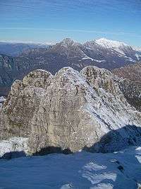
| Bergamasque Prealps | |
|---|---|
.jpg) Mount Concarena - view from Naquane Val Camonica | |
| Highest point | |
| Peak | Mount Concarena |
| Elevation | 2,549 m (8,363 ft) |
| Coordinates | 46°00′41″N 10°16′46″E |
| Naming | |
| Native name | Prealpi Bergamasche |
| Geography | |
| Country | |
| Region | |
| Province | Lecco |
| Parent range | Bergamasque Alps and Prealps |
| Borders on | Bergamo Alps, Lugano Prealps, Brescia and Garda Prealps and Po plain |
| Geology | |
| Orogeny | Alpine orogeny |
| Type of rock | Sedimentary rocks[1] |
Geography
Administratively the range belongs to the Italian province of Bergamo and, to a lesser extent, to the provinces of Lecco and Brescia.
The western slopes of the mountains are drained by the Adda, the central and eastern part of the range by Oglio and other minor rivers and streams, all of them tributaries of the Po.
SOIUSA classification
According to SOIUSA (International Standardized Mountain Subdivision of the Alps) the mountain range is an Alpine subsection, classified in the following way:[2]
- main part = Eastern Alps
- major sector = Southern Limestone Alps
- section = Bergamasque Alps and Prealps
- subsection = Bergamasque Prealps
- code = II/C-29.II
Borders
The Bergamo Prealps stretch between Lake Como (west) and Lake Iseo (east). They are separated from the Bergamo Alps (north) by some secondary valleys of Val Brembana, Val Seriana and Val Camonica: Valsassina, Valtorta, Val Secca, Valcanale, Val Nembo, Val di Scalve and Val Paisco. Towards south they end with the Po plain.
Subdivision
The Bergamasque Prealps are subdivided into three supergroups:[2]
- Catena Campelli-Resegone-Grigne (or Prealpi Bergamasche Occidentali) - SOIUSA code: II/C-29.II-A,
- Catena Arera-Alben (or Prealpi Bergamasche Centrali) - SOIUSA code: II/C-29.II-B,
- Catena Presolana-Pora-Concarena (or Prealpi Bergamasche Orientali) - SOIUSA code: II/C-29.II-C.
Notable summits
Some notable summits of the range are:
| Name | metres |
|---|---|
| Concarena | 2,549 |
| Presolana | 2,521 |
| Pizzo Arera | 2,512 |
| Pizzo Camino | 2,492 |
| Grigna | 2,410 |
| Cime di Lemma | 2,348 |
| Cima del Fop | 2,322 |
| Monte Secco | 2,267 |
| Monte Resegone | 1,875 |
| Monte Pora | 1,880 |
| Monte Negrino | 1,781 |
| Monte Due Mani | 1,666 |
| Pizzo Formico | 1,636 |
| Monte Linzone | 1,392 |
| Monte Misma | 1,160 |
| Canto Alto | 1,146 |
| Monte Canto | 710 |
See also
- Bergamo Alps
Maps
- Italian official cartography (Istituto Geografico Militare - IGM); on-line version: www.pcn.minambiente.it
References
- VV. AA. (2002). Bergamo e provincia (in Italian). Touring Club Italiano. p. 19.
- Marazzi, Sergio (2005). Atlante Orografico delle Alpi. SOIUSA (in Italian). Priuli & Verlucca. ISBN 978-88-8068-273-8.