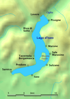
Lake Iseo
Lake Iseo or Iseo lake (US: /iːˈzeɪoʊ/ ee-ZAY-oh;[1] Italian: Lago d'Iseo [ˈlaːɡo diˈzɛːo]; Eastern Lombard: Lach d'Izé), also known as Sebino (Italian: [seˈbiːno]; Latin: Sebinus), is the fourth largest lake in Lombardy, Italy, fed by the Oglio river.
| Lake Iseo | |
|---|---|
 Lake Iseo | |
 map | |
| Location | Lombardy |
| Coordinates | 45°43′N 10°05′E |
| Native name | Lago d'Iseo / Sebino (Italian) Lach d'Izé (Lombard) |
| Primary inflows | Oglio |
| Primary outflows | Oglio |
| Catchment area | 1,777 km2 (686 sq mi) |
| Basin countries | Italy |
| Max. length | 25 km (16 mi) |
| Surface area | 65.3 km2 (25.2 sq mi) |
| Average depth | 124 m (407 ft) |
| Max. depth | 251 m (823 ft) |
| Residence time | 8.8 years |
| Surface elevation | 185 m (607 ft) |
| Islands | Monte Isola, Loreto, St. Paul |
| Settlements | see article |
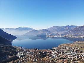
It is in the north of the country in the Val Camonica area, near the cities of Brescia and Bergamo. The lake is almost equally divided between the Provinces of Bergamo and Brescia. Northern Italy is known for its heavily industrialised towns and in between there are several natural lakes. Lake Iseo retains its natural environment, with its lush green mountains surrounding the crystal clear lake.
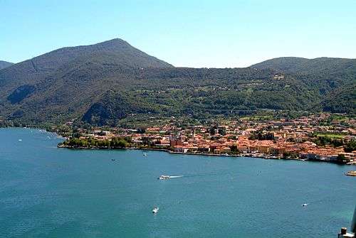
There are several medieval towns around the lake, the largest being Iseo and Sarnico. A notable tourism sector has emerged.
A road has been carved into the side of the mountains that circumnavigates the entire lake.
In the middle of the lake there are Montisola island, Loreto isle and San Paolo isle (which compound the Monte Isola municipality). There is easy access via the regular running lake ferries.[2]
The Floating Piers, an art installation by Christo and Jeanne-Claude, was open to the public at Lake Iseo for 16 days in June and July 2016.
Since 2018, the northern portion of the lake (called Alto Sebino) is part of the UNESCO World Biosphere Reserve of "Valle Camonica - Alto Sebino".[3][4]
| Valle Camonica - Alto Sebino Biosphere Reserve | |
|---|---|
 View of Alto Sebino from Grignaghe | |
| Location | Lombardy, Italy |
| Area | 1,355.65 square kilometres (523.42 sq mi) |
| Established | 2018 |
| Governing body | Comunità Montana di Valle Camonica |
| Website | http://www.cmvallecamonica.bs.it |
Hydrography

The level of the lake is regulated by the dam of Sarnico, built in 1933 in Fosio. The work, built in concrete and steel, is managed by the Consorzio dell'Oglio which divides the water withdrawn between irrigation uses and hydroelectric uses.[5]
Settlements
Around the shore of the lake are some small towns:
| Brescia |
Bergamo |
|---|---|
|
| |
Two smaller islands, Loreto and St. Paul, are privately owned.
References
- "Iseo, Lake". Merriam-Webster Dictionary. Retrieved 1 August 2019.
- "Lake Iseo Ferryboat". Navigazione Lago Iseo. Retrieved 14 July 2016.
- UNESCO (26 July 2018). "Twenty-four new sites join UNESCO's World Network of Biosphere Reserves 26 July 2018". Retrieved 1 November 2019.
- UNESCO. "Valle Camonica – Alto Sebino Biosphere Reserve, Italy". Archived from the original on 1 November 2019. Retrieved 1 November 2019.
- Clemente, R. (4 November 2013). "Sarnico: la diga compie 80 anni Difende il lago, irriga la Bassa" [Sarnico: the dam is 80 years old(. It) defends the lake, irrigates the low (Bergamo and Brescia provinces)] (in Italian). L'eco di Bergamo.
External links
| Wikimedia Commons has media related to Lago d'Iseo. |