Belait District
Belait District (Malay: Daerah Belait), or simply Belait (Malay: [bəlait] (![]()
Belait Daerah Belait دأيره بلأيت | |
|---|---|
| Belait District | |
 | |
| Capital | Kuala Belait |
| Government | |
| • Body | Belait District Office (Malay: Jabatan Daerah Belait) |
| • District Officer (Malay: Ketua Jabatan Pegawai Daerah) | Awang Ramlee bin Haji Jamudin |
| • Deputy District Officer (Timbalan Ketua Pegawai Daerah) | Awang Abdol Hazis bin Haji Ahad |
| Area | |
| • Belait District | 2,727 km2 (1,053 sq mi) |
| Population (2019)[3] | |
| • Belait District | 75,900 |
| • Density | 28/km2 (72/sq mi) |
| Postal code | Kxxxxx |
| Calling code | +673 3XX, +673 322 Seria, +673 323 Labi[4] |
| Vehicle registration | KH and KJ Kuala Belait KA, KB, KC, KD, KE, KF, KG, KK, KL, KM, KN, KP[5] |
| Website | http://www.belait.gov.bn |
Location and geography

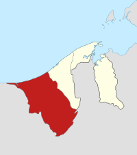
The district borders the South China Sea to the north, the Bruneian district of Tutong to the east and the Malaysian state of Sarawak to the south and west.
The district covers 2,727 square kilometres (1,053 sq mi),[2] which is about half the area of the entire nation. The landscape of the district varies from the peat swamps and lowland forests near the coast to the montane rainforest in the interior parts of the district.
The Belait River flows through Belait and it is the longest river in Brunei. The Belait River, together with its tributaries drains the district – the Belait district roughly corresponds to the drainage basin of the Belait River.
Administration
Belait District is administered by the Jabatan Daerah Belait or Belait District Office. It is headed by a District Officer, and the incumbent is Ramlee bin Hj Jamudin.[1]

The district is further subdivided into 8 mukims or subdistricts, namely:[6]
Each mukim is composed of a number of villages or kampongs.
Population
The 2016 census records the population of Belait District as 69,992.[7] most of whom live in Kuala Belait, the main town and Seria. The native inhabitants of the district are the Belait People and together with the other Bumiputera races form a majority in the district. A minority of this population is ethnic Chinese, particularly those speaking Cantonese, Taishan, and Hakka. Ibans, Penans and other indigenous people make up the rest of the population. Also present are a large community of expatriates (Caucasians, Indians, Filipinos) mostly working with or associated with the oil and gas industry.
Although it is the second most populous district, it has the lowest average population density (27 persons per square kilometer) of all four districts due to its large area. The population distribution is uneven, the areas around the coast are more densely settled than the mountainous interior rainforests. The largest urban areas in terms of population are the district administrative capital of Kuala Belait and the oil town of Seria.
Transportation
Road
The district is connected by the Seria/Lumut bypass to the Muara-Tutong highway to the east and by the Rasau Bridge to Sungai Tujoh and Miri in the west. Roads near the coast, particularly in the urban areas of Kuala Belait, Seria and Sungai Liang are mostly surfaced and in good condition. Roads towards the interior – Labi, Melilas and Sukang – are partially surfaced, but may sustain damage from floods and landslides during the rainy season.
Rail
The Japanese built a wooden set of rail lines from Badas to the coast during the Second World War. This is no longer in use and has fallen into disrepair.
Ports and ferries
The port of Kuala Belait is one of the three ports in Brunei. It is located on the Belait river and caters to small crafts. (See Kuala Belait.)
A ferry service crosses the mouth of the Belait River linking Kuala Belait to Kampung Sungai Teraban. (This service has been ceased since 2005).
Air
There is one airfield at Anduki, a suburb of Seria. This is used mainly by Shell to transport company personnel to the offshore rigs and platforms. (See Seria.)
The interior villages of Sukang are visited by a regular flying medical service.
There are no commercial flights into and out of the district.
Economy
The Belait District, and Seria town in particular, is the heart of the oil and gas industry in Brunei. It has a large expatriate community, including many Dutch people. This is because Royal Dutch Shell has a major presence in the region.
There are two onshore oil and gas fields in the district – the large Seria Oil Field discovered in 1929 which is still producing hydrocarbons even today, and the smaller Rasau Field close to the town of Kuala Belait. The Tali Field, which is an extension of the Seria Field is found in the coastal waters off Seria. Further offshore lies the South-West Ampa, Fairley, Fairley Baram and Egret fields.
The petroleum produced is processed onshore in and around Seria and the majority of it is exported. Some of the oil is refined at the refinery in Seria for local consumption. Natural Gas from the fields are sent to the Brunei Liquefied Natural Gas Plant (BLNG) in Lumut where it is cooled and liquefied. This is exported via tankers to mainly Japan and Korea.
In the eastern part of the district, Liang is currently experiencing a major development with the establishment of SPARK, which is a 271 hectare site developed to be a world class petrochemical hub. The first major investment at SPARK is the USD450 million Methanol plant developed by the Brunei Methanol Company, a joint venture between Petroleum Brunei and two leading Japanese companies, Mitsubishi Chemical Holdings Corporation and Itochu Corporation. The plant is scheduled for completion in the first quarter of 2010.
References
- (in Malay) "Kementerian Hal Ehwal Dalam Negeri, Negara Brunei Darussalam - Ketua-Ketua Jabatan". Retrieved 2019-09-24.
- (in English) "Belait District" (PDF). p. 8. Retrieved 2017-10-19.
- "Department of Economic Planning and Development - Population". www.depd.gov.bn. Retrieved 2017-12-12.
- (in English) http://www.dialingcode.com/country/brunei
- (in English) Road Traffic Act Revised Edition 2007 Article 59 pp. 28
- (in English) "Belait District" (PDF). pp. 8–9. Retrieved 2017-10-19.
- (in English) "Department of Economic Planning and Development - Population". www.depd.gov.bn. Retrieved 2017-10-19.
External links
| Wikimedia Commons has media related to Belait. |
- (in Malay) Belait District Office website