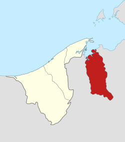
Temburong District
Temburong District (Malay: Daerah Temburong), or simply Temburong (Malay: [tǝmburoŋ] (![]()
Temburong Daerah Temburong دائيره تمبوروڠ | |
|---|---|
| Temburong District | |
 | |
| Capital | Bangar |
| Government | |
| • Body | Jabatan Daerah Temburong (Temburong District Office) |
| • District Officer (Malay: Ketua Jabatan Pegawai Daerah) | Pengiran Muhammad Ameer Mubaarak bin Pengiran Haji Hashim |
| • Deputy District Officer (Timbalan Ketua Pegawai Daerah) | - |
| Area | |
| • Total | 1,306 km2 (504 sq mi) |
| Population (2016)[2] | |
| • Total | 10,543 |
| • Density | 8.1/km2 (21/sq mi) |
| Website | http://temburong.gov.bn |
Geography
The district borders Brunei Bay to the north and Sarawak, Malaysia to the east, south and west. The area covers 1,306 km2 (504 sq mi).[1]
The Temburong River flows through the district, and the Sungai Pandaruan river forms the western section of the border with Malaysia.
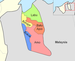
Temburong is divided into five mukim (districts):
Brunei's first national park, the Ulu Temburong National Park, is located south of the Temburong district, covering 550 km2 (210 sq mi) of the Temburong forest. The national park has a scientific research centre facility, the Kuala Belalong Rainforest Field Studies Centre, which is only accessible by boat. 25 hectares (62 acres) of the Kuala Belalong area had been allocated for joint venture research projects conducted by the Universiti Brunei Darussalam, Kuala Belalong Field Studies and the Smithsonian Tropical Research Institute. It is called the "Belalong Rainforest Experience," and is funded by The Hongkong and Shanghai Banking Corporation: Brunei.[3]
An Outward Bound centre can also be found within the national park.
Temburong has 67 km (42 mi) of roads connecting Bangar to interior villages. In addition a further 54 km (34 mi) of roads connect villages in the interior.
A new 30 km (19 mi) roadway connecting the Muara and Temburong districts of Brunei was completed in March 2020.[4] 14 km (8.7 mi) of this roadway crosses the Brunei Bay.[5]
Eco-tourism in Temburong district
Pristine forest still covers most of the district.[6] This leads to the intensive development of the eco-tourism industry in Temburong district. Eco-Tourism promotion events such as "Cuti-Cuti Temburong" ('Temburong holidays') was launched at the end of 2008 by the local tourism group known as "Kenali Negara Kitani" (KNK) ('Know Your Country') to encourage locals and tourists from foreign countries to travel to the Temburong district.[6] The promotion event is a kick-start of the Heart of Borneo project at Brunei vicinity.
Education
Sultan Hassan Secondary School is the district's only secondary school and is located in Bangar. There are also 13 primary schools spread across the district since one of them was shut down.
Health
In 1987 the $10 million Pengiran Isteri Hajah Mariam Hospital opened, providing 50 beds and a variety of medical services. A number of village clinics also exist.
Security
The district has an army presence at Bangar Camp. There is one main police headquarters in Bangar and numerous police posts around the district.
Use by SAF
The SAF Commandos regularly conducts jungle training here. A Singapore army camp is also located in between Kampung Negalang and the other town that is called the Lakiun.
Recreation
Popular sports in Temburong include football, top-spinning, netball and sepak takraw.
Notes
- "Temburong District" (PDF). p. 8. Retrieved 2017-10-17.
- "Department of Economic Planning and Development - Population". www.depd.gov.bn. Retrieved 2017-10-17.
- Rasidah, H.A.B. (April 4, 2009). "Project for in-depth study of local forests". The Brunei Times. Archived from the original on April 9, 2009.
- Abu Bakar, Rasidah (16 March 2020). "Temburong bridge opens to traffic today". The Scoop. Archived from the original on 19 March 2020. Retrieved 20 March 2020.
- Rabiatul, Kamit (10 May 2013). "Temburong bridge ready 2018". Brunei Times. Archived from the original on 3 December 2013. Retrieved 10 July 2013.
- "Exploring Brunei in 'Cuti-Cuti Temburong". The Brunei Times. December 6, 2008. Archived from the original on November 24, 2009.
References
- R. Hédl, M. Svátek, M. Dancak, Rodzay A.W., M. Salleh A.B., Kamariah A.S. A new technique for inventory of permanent plots in tropical forests: a case study from lowland dipterocarp forest in Kuala Belalong, Brunei Darussalam, In Blumea 54, 2009, p 124–130. Publié 30. 10. 2009.
External links
| Wikimedia Commons has media related to Temburong. |