Bearpaw Formation
The Bearpaw Formation, also called the Bearpaw Shale, is a geologic formation of Late Cretaceous (Campanian) age. It outcrops in the U.S. state of Montana, as well as the Canadian provinces of Alberta and Saskatchewan, and was named for the Bear Paw Mountains in Montana.[2] It includes a wide range of marine fossils, as well as the remains of a few dinosaurs. It is known for its fossil ammonites, some of which are mined in Alberta to produce the organic gemstone ammolite.[3]
| Bearpaw Formation Stratigraphic range: Campanian-Maastrichtian, 75–72 Ma | |
|---|---|
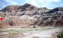 Contact (red arrow) between the underlying marine shales of the Bearpaw Formation and the coastal Horseshoe Canyon Formation. | |
| Type | Geological formation |
| Unit of | Montana Group |
| Underlies | Horseshoe Canyon Formation, St. Mary River Formation, Eastend Formation, and others |
| Overlies | Dinosaur Park Formation, Judith River Formation |
| Thickness | Up to 350 meters (1,150 ft)[1] |
| Lithology | |
| Primary | Shale, claystone |
| Other | Siltstone, sandstone, concretionary beds |
| Location | |
| Coordinates | 48°15′0″N 109°30′0″W |
| Region | Alberta, Saskatchewan, Montana |
| Country | Canada, United States |
| Extent | Northern Montana to central Alberta and southern Saskatchewan |
| Type section | |
| Named for | Bear Paw Mountains, Montana |
| Named by | Hatcher and Stanton, 1903[2] |
Lithology and depositional environment
The formation was deposited in the Bearpaw Sea, which was part of the Western Interior Seaway that advanced and then retreated across the region during Campanian time.[4] It is composed primarily of dark grey shales, claystones, silty claystones and siltstones, with subordinate silty sandstones. It also includes bedded and nodular concretions (both calcareous and ironstone concretions) and thin beds of bentonite. As the seaway retreated toward the southwest, the marine sediments of the Bearpaw became covered by the deltaic and coastal plain sediments of the overlying formations.[1][5][6]
Relationship to other units
The Bearpaw Formation conformably overlies the Dinosaur Park Formation of the Belly River Group in central Alberta, and the Judith River Formation in the plains to the east and Montana. It is overlain by the Horseshoe Canyon Formation in central Alberta; by the Blood Reserve Formation and the St. Mary River Formation in southern Alberta; by the Eastend Formation in southern Saskatchewan; and by the Fox Hills Formation in Montana. To the east, it merges into the Pierre Shale.[1]
Fauna
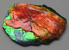
The Bearpaw Formation is famous for its well-preserved ammonite fossils. These include Placenticeras meeki and Placenticeras intercalare, and the baculite Baculites compressus, some of which are mined south-central Alberta to produce the organic gemstone ammolite.[3]
Other fossils found in this formation include many types of shellfish, bony fish, sharks, rays, birds, and marine reptiles like mosasaurs such as Prognathodon overtoni and Plioplatecarpus peckensis, plesiosaurs such as Dolichorhynchops herschelensis, Albertonectes and Nakonanectes, and sea turtles. Dinosaur remains have occasionally been discovered, presumably from carcasses that washed out to sea.[7][8]
Dinosaurs
| Dinosaurs reported from the Bearpaw Formation | ||||||
|---|---|---|---|---|---|---|
| Genus | Species | Location | Stratigraphic position | Material | Description | Images |
|
Indeterminate[7] |
| |||||
| Daspletosaurus | ||||||
|
Indeterminate[7] |
||||||
|
cf. Kritosaurus |
"Nearly complete skull and postcranium."[9] |
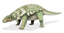
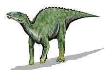
A hadrosaurid | ||||
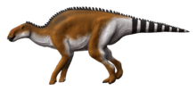
|
P. maximus[10] |
Three juvenile specimens[10] |
A Saurolophinae hadrosaurid, also known from the Dinosaur Park and Two Medicine Formations | ||||
|
Indeterminate[7] |
||||||


References
- Glass, D.J. (editor) 1997. Lexicon of Canadian Stratigraphy, vol. 4, Western Canada including eastern British Columbia, Alberta, Saskatchewan and southern Manitoba. Canadian Society of Petroleum Geologists, Calgary, 1423 p. on CD-ROM. ISBN 0-920230-23-7.
- Hatcher, J.B. and Stanton, T.W., 1903. The stratigraphic position of the Judith River beds and their correlation with the Belly River beds. Science, no. 5, v. 18, p. 211-212.
- Mychaluk, K.A.; Levinson, A.A. & Hall, R.H. "Ammolite: Iridescent fossil ammonite from southern Alberta, Canada" (PDF). Gems & Gemology. 37 (1): 4-25. Retrieved 2015-01-11.
- "Latest Cretaceous Western Interior Seaway". Archived from the original on 2011-09-27. Retrieved 2007-06-22.
- Canadian Society of Petroleum Geologists (1994). "The Geological Atlas of the Western Canada Sedimentary Basin, Chapter 24: Upper Cretaceous and Tertiary strata of the Western Canada Sedimentary Basin". Compiled by Mossop, G.D. and Shetsen, I. Archived from the original on 2016-07-01. Retrieved 2016-06-20.
- Wall, J.H., Sweet, A.R. and Hills, L.V. 1971. Paleoecology of the Bearpaw and contiguous Upper Cretaceous formations in the C.P.O.G. Strathmore well, southern Alberta. Bulletin of Canadian Petroleum Geology, vol. 19, no. 3, p. 691-702.
- Weishampel, David B; et al. (2004). "Dinosaur distribution (Late Cretaceous, North America)." In: Weishampel, David B.; Dodson, Peter; and Osmólska, Halszka (eds.): The Dinosauria, 2nd, Berkeley: University of California Press. Pp. 574-588. ISBN 0-520-24209-2.
- Bearpaw fauna in Alberta
- "Table 20.1," in Weishampel, et al. (2004). Page 441.
- Eamon T. Drysdale; François Therrien; Darla K. Zelenitsky; David B. Weishampel; David C. Evans (2019). "Description of juvenile specimens of Prosaurolophus maximus (Hadrosauridae: Saurolophinae) from the Upper Cretaceous Bearpaw Formation of southern Alberta, Canada, reveals ontogenetic changes in crest morphology". Journal of Vertebrate Paleontology. in press: e1547310. doi:10.1080/02724634.2018.1547310.