Barenton-sur-Serre
Barenton-sur-Serre is a commune in the department of Aisne in the Hauts-de-France region of northern France.
Barenton-sur-Serre | |
|---|---|
 The Town Hall | |
Location of Barenton-sur-Serre 
| |
 Barenton-sur-Serre  Barenton-sur-Serre | |
| Coordinates: 49°40′20″N 3°40′52″E | |
| Country | France |
| Region | Hauts-de-France |
| Department | Aisne |
| Arrondissement | Laon |
| Canton | Marle |
| Intercommunality | Pays de la Serre |
| Government | |
| • Mayor (2014-2020) | Bruno Séverin |
| Area 1 | 8.05 km2 (3.11 sq mi) |
| Population (2017-01-01)[1] | 134 |
| • Density | 17/km2 (43/sq mi) |
| Time zone | UTC+01:00 (CET) |
| • Summer (DST) | UTC+02:00 (CEST) |
| INSEE/Postal code | 02048 /02270 |
| Elevation | 61–122 m (200–400 ft) |
| 1 French Land Register data, which excludes lakes, ponds, glaciers > 1 km2 (0.386 sq mi or 247 acres) and river estuaries. | |
Geography
Barenton-sur-Serre is located some 35 km south-east of Saint-Quentin and 15 km north-east of Laon. National Route N2 passes through the commune from Froidmont-Cohartille in the north-east running south-west through the commune. Access to the village is by road D3060 running west from the N2 to the village then continuing north-west to road D12. There is also access to the village on a country road from Froidmont-Cohartille. There is quite a large area of forest north of the village and in a belt extending south-east of the village. The rest of the commune is all farmland.[2]
The Ru de Barentons flows from the south of the commune into the Souche river which flows from east to west through the commune then continues north-west to join the Serre river.[2]
Neighbouring communes and villages[2]
Places adjacent to Barenton-sur-Serre | ||||||||||
|---|---|---|---|---|---|---|---|---|---|---|
| ||||||||||
Administration
List of Successive Mayors of Barenton-sur-Serre[3]
| From | To | Name | Party | Position |
|---|---|---|---|---|
| 1995 | 2008 | Gérard Cuvillier | DVD | |
| 2008 | 2014 | Sébastien Lhermine | ||
| 2014 | Present | Bruno Séverin |
(Not all data is known)
Population
| Historical population | ||
|---|---|---|
| Year | Pop. | ±% |
| 2006 | 111 | — |
| 2007 | 111 | +0.0% |
| 2008 | 110 | −0.9% |
| 2009 | 113 | +2.7% |
| 2010 | 115 | +1.8% |
| 2011 | 118 | +2.6% |
| 2012 | 118 | +0.0% |
| 2013 | 117 | −0.8% |
| 2014 | 121 | +3.4% |
| 2015 | 126 | +4.1% |
| 2016 | 130 | +3.2% |
Gallery
 The Church
 Jedburgh Augustus Memorial
 The Souche river from the bridge
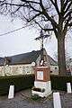 The War Memorial
See also
External links
- Barenton-sur-Serre on the old National Geographic Institute website (in French)
- 40000 Bell Towers website (in French)
- Barenton-sur-Serre on Lion1906
- Barenton-sur-Serre on Géoportail, National Geographic Institute (IGN) website (in French)
- Baranton sur Serre on the 1750 Cassini Map
- Barenton-sur-Serre on the INSEE website (in French)
Notes and references
Notes
References
- "Populations légales 2017". INSEE. Retrieved 6 January 2020.
- Google Maps
- List of Mayors of France (in French)
| Wikimedia Commons has media related to Barenton-sur-Serre. |
| Authority control |
|
|---|