Achery, Aisne
Achery is a French commune in the department of Aisne in the Hauts-de-France region of northern France.
Achery | |
|---|---|
 Achery Town Hall | |
Location of Achery 
| |
 Achery  Achery | |
| Coordinates: 49°41′35″N 3°23′26″E | |
| Country | France |
| Region | Hauts-de-France |
| Department | Aisne |
| Arrondissement | Laon |
| Canton | Tergnier |
| Intercommunality | Chauny-Tergnier-La Fère |
| Government | |
| • Mayor (2014-2020) | Georges Demoulin |
| Area 1 | 6.9 km2 (2.7 sq mi) |
| Population (2016) | 602 |
| • Density | 87/km2 (230/sq mi) |
| Time zone | UTC+01:00 (CET) |
| • Summer (DST) | UTC+02:00 (CEST) |
| INSEE/Postal code | 02002 /02800 |
| Elevation | 48–103 m (157–338 ft) (avg. 50 m or 160 ft) |
| 1 French Land Register data, which excludes lakes, ponds, glaciers > 1 km2 (0.386 sq mi or 247 acres) and river estuaries. | |
The inhabitants of the commune are known as Acheryens or Acheryennes.[1]
Geography
Achery is located some 20 km south by south-east of Saint-Quentin and 10 km north-east of Tergnier. The commune is on the Oise river which flows south forming the north-western border of the commune before flowing through the commune and continuing south. The tributary of the Oise, the Serre, forms the southern border of the commune before joining the Oise just south of Achery. The town of Achery is about 1.5 km directly south of Mayot on Highway D13 which passes through Achery south to Danizy. Other roads into the commune are the D643 (Rue Jules Lesage) west from the village to Travecy and also east (Rue Jean Moulin) to Anguilcourt-le-Sart. The Rue de Fort forms most of the northern border of the commune with various country roads forming most of the western border.[2]
Neighbouring communes and villages[2]
Places adjacent to Achery, Aisne | |
|---|---|
Some distance from the town there is a quarry and an old gunpowder factory.
History
In the distant past, the village was called Achiriacus in 990.
Achery had its own lords. The lordship had his castle but it was destroyed once before being rebuilt in the 14th century. The lordship fell to the Count of Anizy. During the French Revolution the castle was destroyed and Achery became an independent commune. During the First World War, the village was completely destroyed but was rebuilt after the war.
Administration
List of Mayors of Achery[3]
| From | To | Name | Party | Position |
|---|---|---|---|---|
| 2001 | Current | Georges Demoulin | DVD |
(Not all data is known)
Population
| Historical population | ||
|---|---|---|
| Year | Pop. | ±% |
| 2006 | 533 | — |
| 2007 | 539 | +1.1% |
| 2008 | 546 | +1.3% |
| 2009 | 567 | +3.8% |
| 2010 | 587 | +3.5% |
| 2011 | 608 | +3.6% |
| 2012 | 620 | +2.0% |
| 2013 | 620 | +0.0% |
| 2014 | 614 | −1.0% |
| 2015 | 608 | −1.0% |
| 2016 | 602 | −1.0% |
| 1793 | 1800 | 1806 | 1821 | 1831 | 1836 | 1841 | 1846 | 1851 |
|---|---|---|---|---|---|---|---|---|
| 689 | 761 | 754 | 862 | 1,046 | 1,099 | 1,125 | 1,117 | 1,088 |
| 1856 | 1861 | 1866 | 1872 | 1876 | 1881 | 1886 | 1891 | 1896 |
|---|---|---|---|---|---|---|---|---|
| 1,099 | 1,074 | 1,046 | 924 | 927 | 895 | 908 | 809 | 763 |
| 1901 | 1906 | 1911 | 1921 | 1926 | 1931 | 1936 | 1946 | 1954 |
|---|---|---|---|---|---|---|---|---|
| 671 | 687 | 655 | 451 | 464 | 449 | 469 | 520 | 501 |
| 1962 | 1968 | 1975 | 1982 | 1990 | 1999 | 2006 | 2010 | - |
|---|---|---|---|---|---|---|---|---|
| 508 | 524 | 508 | 578 | 564 | 540 | 533 | 587 | - |

Politics
Presidential Elections 2nd Round [4]
| Election | Winning Candidate | Party | % | |
|---|---|---|---|---|
| 2017 | Marine Le Pen | FN | 65.68 | |
| 2012 | François Hollande | PS | 52.52 | |
| 2007 | Nicolas Sarkozy | UMP | 52.87 | |
| 2002 | Jacques Chirac | RPR | 60.07 | |
Events
- Flea market in May
- Festival on the third Sunday in June
Sites and monuments

- The Church of Saint-Martin: rebuilt after the First World War
- An Old water mill
- The Dovecote Square
- Marshes and ponds
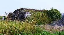
- Remains of many blockhouses of the Hindenburg Line
See also
External links
- Achery on Lion1906
- Achery on Google Maps
- Achery on Géoportail, National Geographic Institute (IGN) website (in French)
- Achery on the 1750 Cassini Map
- Achery on the INSEE website (in French)
- INSEE (in French)
Notes and references
Notes
References
| Wikimedia Commons has media related to Achery. |