Baraachit
Baraachit (Arabic: برعشيت), also spelt Brashit,[1] is a rural town located in the Nabatiye Governorate, in the Bint Jbeil District of southern Lebanon, ca. 3.5 kilometres (2.2 mi) southeast of Tibnine and about 80 kilometres (50 mi) from Beirut.[2] The village sits on an elevation of 710 metres (2,330 ft) above sea level. The town has a mixed population of Shi'a and Christians.
Baraachit برعشيت | |
|---|---|
City | |
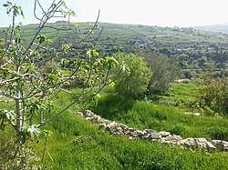 Pastoral view of Baraachit | |
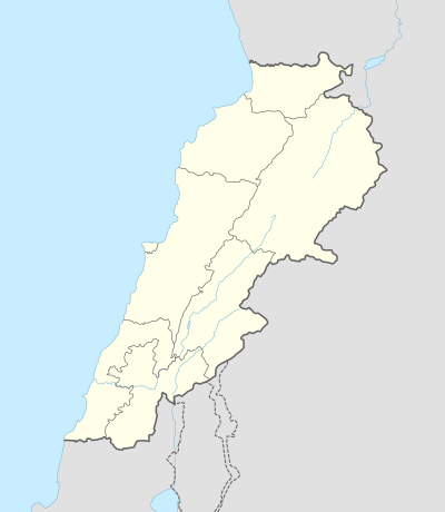 Baraachit Location within Lebanon | |
| Coordinates: 33°10′34″N 35°26′36″E | |
| Grid position | 191/286 PAL |
| Country | |
| Governorate | Nabatieh Governorate |
| District | Bint Jbeil District |
| Elevation | 710 m (2,330 ft) |
| Time zone | UTC+2 (EET) |
| • Summer (DST) | UTC+3 (EEST) |
| Dialing code | +961 (07) |
History
The village once marked the northernmost extent of Jewish settlement upon their return from Babylonian exile in the 4th century BCE, and is mentioned in the 3rd century Mosaic of Rehob.[3] By 64 BCE, the region had come under the control of the Roman empire.[4] Since ancient times, the area has been known as Jabal 'Amilah, and later as Jabal 'Amil (Jabal Amel), an area that shoulders the Galilee and overlooks Palestine, with a predominant Shi'ite population.[5]
In 1596, the village ‘’Bra’sit’’ was named in the Ottoman nahiya (subdistrict) of Tibnin under the liwa' (district) of Safad, with a population of 45 households and 7 bachelors, all Muslim. The villagers paid taxes on agricultural products, such as wheat, barley, olive trees, fruit trees, goats and beehives, in addition to "occasional revenues" and a fixed sum; a total of 13,370 akçe.[6][7]
In 1875, Victor Guérin visited, and found here “a cistern partly cut in the rock, and partly constructed, seems ancient.”[8] He found 400 Metawileh and 60 Greek Orthodox.[9]
In 1881, British explorers, C. R. Conder and H. H. Kitchener, surveyed parts of southern Lebanon, mentioning ten villages in the Belad Besharah region, among which is listed Ber'ashit (sic): "A large village, containing about 500 Metawileh and 200 Christians. It is situated on the side of a hill, and surrounded by figs, olives, and arable cultivation. There is a good spring and several cisterns in the village."[10]
The current Bint Jbeil province was created in 1922 by French colonials.[11]
Climate
Baraachit enjoys a temperate climate which is characteristic of south Lebanon: Mild rainy winters and arid summers with a few excessively warm days.
References
- A proper noun used to designate a place, according to Palmer 1881, p. 19
- Baraachit, Lebanon – General Facts
- Abel, F.M. (1933), p. 309, s.v. Meraḥseth; Frankel, R. & Finkelstein, I. (1983), p. 44; Klein, S. & Hildesheimer, Naphtali Z. (1965), pp. 58, 126.
- The World Book Encyclopedia, vol. 1, Chicago 1982, p. 151; The World Book Encyclopedia, vol. 12, Chicago 2002, p. 172; Ḥaddād, Jūrj Marʻī (1956), p. 10
- Dagher, Carole H. (2000), p. 32
- Hütteroth and Abdulfattah, 1977, p. 179
- Note that Rhode, 1979, p. 6 writes that the register that Hütteroth and Abdulfattah studied was not from 1595/6, but from 1548/9
- Guérin, 1880, p. 377, as given in Conder and Kitchener, 1881, SWP I; p. 114
- Guérin, 1880, p. 377
- Conder and Kitchener, 1881, p.94
- Rida, A. (2009), pp. 138, 179, 180, 183, 227.
Bibliography
- Abel, F.M. (1933). Géographie de la Palestine (in French). 1. Paris.
- Conder, C.R.; Kitchener, H.H. (1881). The Survey of Western Palestine: Memoirs of the Topography, Orography, Hydrography, and Archaeology. 1. London: Committee of the Palestine Exploration Fund.
- Dagher, Carole H. (2000). Bring Down the Walls: Lebanon's Post-War Challenge. New York. ISBN 978-0-312-29336-9.
- Frankel, Raphael; Finkelstein, I. (1983). "'The Northwest Corner of Eretz-Israel' in the Baraita 'Boundaries of Eretz-Israel'". Cathedra: For the History of Eretz Israel and its Yishuv (in Hebrew). 27 (27): 39–46. JSTOR 23398920.
- Guérin, V. (1880). Description Géographique Historique et Archéologique de la Palestine (in French). 3: Galilee, pt. 2. Paris: L'Imprimerie Nationale.
- Ḥaddād, Jūrj Marʻī (1956). Baalbak, North and South Lebanon: Description, History and Tourist Guide. Damascus.
- Hütteroth, Wolf-Dieter; Abdulfattah, Kamal (1977). Historical Geography of Palestine, Transjordan and Southern Syria in the Late 16th Century. Erlanger Geographische Arbeiten, Sonderband 5. Erlangen, Germany: Vorstand der Fränkischen Geographischen Gesellschaft. ISBN 3-920405-41-2.
- Klein, S.; Hildesheimer, Naphtali Zvi (Hirsch) (1965). The Borders of the Land - Researches. Jerusalem.
- Palmer, E.H. (1881). The Survey of Western Palestine: Arabic and English Name Lists Collected During the Survey by Lieutenants Conder and Kitchener, R. E. Transliterated and Explained by E.H. Palmer. Committee of the Palestine Exploration Fund.
- Rhode, H. (1979). Administration and Population of the Sancak of Safed in the Sixteenth Century. Columbia University.
- Rida, A. (2009). Memoirs of History (مذكرات للتاريخ) (in Arabic). Beirut: Dar An-Nahar.
External links
- Baraachit (Ber'ashit) in the Palestine Exploration Fund Map of 1878, Map 2: IAA, Wikimedia commons
- Baraachit, Localiban
Capital: Bint Jbeil | ||
| Towns and villages |
|  |
| Notable landmarks | ||
| Other sites | ||