Banyuwangi Regency
Banyuwangi Regency is a regency (Indonesian: kabupaten) of East Java province in Indonesia. The regency is located at the easternmost end of Java Island. It serves as a port between Java and Bali. It is surrounded by mountains and forests to the west; by sea to the east and south. Banyuwangi is separated by the Strait of Bali from Bali. With an area of 5,782.4 km2, this regency is the largest in Java. The regency is a tourist destination, and subject to ongoing development as an international tourist destination with relevant infrastructure.[1] Banyuwangi regency has been declared a taman bumi (earth park), or national geological park (Geopark) in 2018.[2]
Banyuwangi Regency Kabupaten Banyuwangi Blambangan | |
|---|---|
| Other transcription(s) | |
| • Osing | ꦑꦧꦸꦥꦠꦺꦤ꧀ꦨꦪꦸꦮꦔꦶ |
.jpg) _from_Bali_strait_at_dawn.jpg) 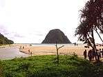   Clockwise, from top left : Ijen volcano complex, Eruption view of Raung from Bali Strait, G-Land, Ketapang Harbour, Pulo Merah Islet | |
 Seal | |
| Motto(s): ꦯꦠꦾꦨꦏ꧀ꦠꦶꦦꦿꦗꦩꦸꦏ꧀ꦠꦶ (official) The Sunrise of Java (informal) | |
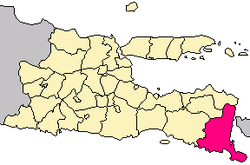 Location within East Java | |
| Coordinates: 8°13′07″S 114°22′01″E | |
| Country | |
| Province | |
| Capital | Banyuwangi |
| Government | |
| • Regent | Abdullah Azwar Anas |
| • Vice Regent | Yusuf Widyatmoko |
| Area | |
| • Total | 5,782.4 km2 (2,232.6 sq mi) |
| Population (2014) | |
| • Total | 1,599,788 |
| • Density | 280/km2 (720/sq mi) |
| Time zone | UTC+7 (IWST) |
| Area code | (+62) 333 |
| Website | banyuwangikab.go.id |

It had a population of 1,488,791 according to the 2000 Census; by the 2010 Census it had risen to 1,556,078; and the latest official estimate (for January 2014) is 1,599,788. The city of Banyuwangi is the administrative capital. The name Banyuwangi is Javanese for "fragrant water", connected to the Javanese folklore of Sri Tanjung.
Society and history

One Banyuwangi native group is the Osing community which has a Hindu culture although they can be considered as a Javanese sub-ethnic group. They live mainly in the central part of Banyuwangi and they sometimes consider themselves as Majapahit descendants. Other groups are Javanese (living mostly in the south and west), Madurese (mainly in the north and coastal area) and Balinese (scattered but more concentrated in the east). Other smaller groups include Chinese, Buginese, and Arabs.
Once known as Blambangan (or its variation: Balambangan and Balumbungan), it was a vassal of the Majapahit Kingdom and a regional trade centre. After the Majapahit Kingdom ceased to exist, it became an independent kingdom and, as such, the last Hindu kingdom of Java. In order to defend itself from the troops of the Sultanate of Demak, which tried to occupy it, Blambangan asked for help from Balinese kings, which caused it to lose its independence to Balinese kingdoms. During this time Blambangan was deeply influenced by Balinese culture. After around 150 years of Balinese occupation, the Sultanate of Mataram gained control of the territory and renamed it Banyuwangi. Later, it was part of the Mataram territory controlled by the VOC (1770). During the expansion of plantations in the 19th century, many parts of Banyuwangi were planted with coffee and sugar cane, which feature its landscape even now. The Chinese and Arabs came mostly during this period.
Banyuwangi people are known for their combination of Islamic and pre-Islamic tradition.
During the Fall of Suharto, a witchhunt in Banyuwangi against alleged sorcerers spiraled into widespread riots and violence. In addition to alleged sorcerers, Islamic clerics were also targeted and killed, Nahdlatul Ulama members were murdered by rioters.[3][4]
Culture
Gandrung Dance
This is a Banyuwangi-typical dance which performed by a woman and along with simple music like violin, triangle (called kluncing), gong (or kempul), kendhang and sometimes with keyboard as result of modern influence. It is performed during night until dawn particularly in parties.
Janger or Damarwulan
Damarwulan is a legendary hero who features in traditional theatre art which has been developed since the 19th century in Banyuwangi. It is a combination of Balinese, Javanese and local cultures. Balinese influences can be seen in its performers' costumes and instruments. Meanwhile, Javanese influences is in its "lakon" or stories as well as language in dialogues. It is distinct from the Balinese Janger.
Administrative subdivisions
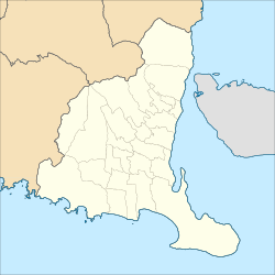
Banyuwangi Regency is divided into 25 districts[5] (Indonesian: kecamatan), listed below with their populations at the 2010 Census:[6]
- Pesanggaran (49,412)
- Siliragung (44,390)
- Bangorejo (59,442)
- Purwoharjo (64,949)
- Tegaldlimo (61,176)
- Muncar (128,924)
- Cluring (70,044)
- Gambiran (58,412)
- Tegalsari (46,161)
- Glenmore (69,471)
- Kalibaru (61,182)
- Genteng (83,123)
- Srono (87,209)
- Rogojampi (92,358)
- Kabat (67,137)
- Blimbingsari (n/a)
- Singojuruh (45,242)
- Sempu (71,281)
- Songgon (50,275)
- Glagah (34,002)
- Licin (27,878)
- Banyuwangi (106,000)
- Giri (28,510)
- Kalipuro (76,178)
- Wongsorejo (74,307)
Transportation
Banyuwangi International Airport at Blimbingsari serves the regency, Banyuwangi city and surrounding area of East Java. Banyuwangi can be reached by road and rail from Surabaya or by ferry from Bali.
Tourism

Many European tourists visiting Bali come to Banyuwangi to surf in Plengkung and dive in Tabuhan Island. Ferries from Bali arrive at the port of Ketapang, some 8 km to the north of Banyuwangi city. Plekung Beach is also known as G-Land or green land have 3 types of waves up to 6 to 8 meters tall.[7]
- Banyuwangi International Surfing Competition 2014
This was the second time competition after the 2012 competition. 23–25 May 2014 competition is followed by at least 15 countries in Pantai Pulau Merah (Red Island Beach) which has 4 meters height and 400 meters long of waves.[8]
- Diamond Triangle
Diamond Triangle consists of:[9]
- Ijen Crater Nature Tourist Park, we can see tosca lake crater and traditional sulphur mining which the sulphur bunch mobilization still use human to hike and down to the crater.
- Alas Purwo National Park, besides see the animals we can surf at G-Land/Plengkung with Money Trees, Speddy's, Kongs, Twenty-twenty and Tiger Track waves.
- Meru Betiri National Park, Sukamade Turtle Breeding Station regularly releases baby marine turtles to open ocean. 4 of 6 kind of turtles can be found in Indonesia regularly visit Sukamade to put their eggs. Penyu Hijau (Chelonia mydas) visit the Sukamade Beach almost everynight, Penyu Lekang (Lepidochelys olivacea) visit in March to June, Penyu Belimbing (Dermochelys coriacea) put the egg every 4 years in June to September and the scare Penyu Sisik (Eremochelys olivacea) very seldom to visit the beach.
- Waterfalls
Visitors may be interested to find several waterfalls in one locality. Opened formally in 2014, there are a number of waterfalls in Kampung Anyar (New Village), near Kalibendo Plantation, around 15 kilometers from Banyuwangi on the way to Mount Ijen. There are 3 waterfalls near to each other known as the "Triple Waterfall" to be found 10 minutes walk down the stairs from a parking area. Or about 300 meters along the river, walking uphill, Kethagen Waterfall can be found. The cliff besides the river can reflect sunlight, glittering like diamonds.[10]
Climate
Banyuwangi has a temperate tropical and wet dry climate, similar to Banyuwangi's dry season start from May until October, and the rest is wet season. in 2013, Banyuwangi's highest average temperature is on October with 28.2 °C and lowest average temperature is on April with 24.8 °C
| Climate Data For Banyuwangi | ||||||||||||
|---|---|---|---|---|---|---|---|---|---|---|---|---|
| Year | 2013 | |||||||||||
| Month | Jan | Feb | Mar | Apr | May | June | July | Aug | Sept | Oct | Nov | Dec |
| Av. High (Celsius) | 31.7 | 32.3 | 32 | 31.7 | 31.5 | 30.3 | 29.6 | 29.4 | 30.1 | 32.5 | 31.9 | 31.7 |
| Daily (Celsius) | 26.7 | 27.7 | 27.4 | 24.8 | 27.5 | 27 | 26.1 | 26 | 26.3 | 28.2 | 27.4 | 27.2 |
| Av. Low (Celsius) | 24.1 | 24.7 | 24.3 | 24.8 | 24.7 | 24.4 | 24.6 | 23.3 | 23.6 | 24.7 | 24.6 | 24.4 |
| AV. Rainfall (mm) | 527.5 | 100.2 | 193.1 | 228.8 | 97.3 | 122.8 | 156 | 37.3 | 6.9 | 0.8 | 237.6 | 160.3 |
| Av. Rainy Days | 25 | 14 | 19 | 16 | 16 | 18 | 19 | 8 | 4 | 4 | 21 | 21 |
| Source:[11][12] | ||||||||||||
| Wind Speed and Humidity | ||||||||||||
|---|---|---|---|---|---|---|---|---|---|---|---|---|
| Month | Jan | Feb | Mar | Apr | May | Jun | Jul | Aug | Sep | Oct | Nov | Dec |
| Wind Speed (Knot) | 3.1 | 3.2 | 3.2 | 3.1 | 3.2 | 2.6 | 3 | 3 | 2.8 | 3.1 | 2.3 | 2.1 |
| Humidity (%) | 86 | 81 | 82 | 83 | 84 | 86 | 82 | 78 | 77 | 75 | 82 | 83 |
| Source:[13] | ||||||||||||
| Air Pressure and Sunlight Exposure | ||||||||||||
|---|---|---|---|---|---|---|---|---|---|---|---|---|
| Month | Jan | Feb | Mar | Apr | May | Jun | Jul | Aug | Sep | Oct | Nov | Dec |
| Air Pressure (mb) | 1008.7 | 1008.3 | 1010.2 | 1004.2 | 1010.2 | 1009.2 | 1011.5 | 1012.8 | 1012.8 | 1012.4 | 1009.5 | 1008.8 |
| Sunlight Exposure | 45 | 71 | 72 | 67 | 70 | 58 | 60 | 87 | 96 | 99 | 67 | 61 |
| Source:[14] | ||||||||||||
Environment
The forest and river in Banyuwangi is well-preserved, says the Indonesia Dragonfly Society because they found 3 dragonfly species which only can live in good environment.[15]
Nevertheless, there are local controversies in the Regency over the impact of gold mining activities in the locality of Tumpang Pitu village. In 2006, the Banywangi regency administration granted a mining licence to one company, PT Indo Multi Niaga, which later transferred the licence to another company. However, the local community had expressed concern about gold mining activities as early as 1997. The issues partly related to the protection of the area around a local Hindu temple, partly relate to environmental matters, and partly related to local community views about the economic and social impact of the mining.[16]
Gallery
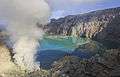 Ijen Crater
References
- "Indonesia announces 10 new destination brands". The Jakarta Post. Retrieved 11 August 2019.
- "Banyuwangi regency declared national geopark area". The Jakarta Post. Retrieved 11 August 2019.
- "The Banyuwangi murders". Inside Indonesia. Retrieved 2020-06-03.
- "Breaking News, Analysis, Politics, Blogs, News Photos, Video, Tech Reviews - TIME.com". Time. October 19, 1998.
- "Banyuwangi Resmi Punya 25 Kecamatan" (in Indonesian). Regency government of Banyuwangi. Retrieved 9 January 2017.
- Biro Pusat Statistik, Jakarta, 2011.
- "Pantai Plekung, Destinasi untuk Berselancar". October 17, 2011. Archived from the original on 2011-10-18.
- "Puluhan Peselancar Mancanegara Ikuti Kompetisi Surfing di Banyuwangi". May 17, 2014.
- "Triangle Diamond Banyuwangi". Archived from the original on December 6, 2013. Retrieved November 3, 2013.
- Agoes Santoso. "Segarnya Air Terjun Kembar Kampung Anyar". Retrieved January 31, 2015.
- "BPS Kabupaten Banyuwangi". banyuwangikab.bps.go.id. Archived from the original on 2016-04-23. Retrieved 2016-04-12.
- "BPS Kabupaten Banyuwangi". banyuwangikab.bps.go.id. Archived from the original on 2016-04-23. Retrieved 2016-04-12.
- "BPS Kabupaten Banyuwangi". banyuwangikab.bps.go.id. Archived from the original on 2016-04-23. Retrieved 2016-04-12.
- "BPS Kabupaten Banyuwangi". banyuwangikab.bps.go.id. Archived from the original on 2016-04-23. Retrieved 2016-04-12.
- Ika Ningtyas (January 30, 2014). "Rare Dragonfly Species Found in Banyuwangi".
- Indra Harsaputra, 'Banyuwangi mining site risks triggering social conflight: Experts', The Jakarta Post, 30 January 2016
External links
![]()
- (in Indonesian) Official site Banyuwangi site

| Authority control |
|---|