Bankura Sadar subdivision
Bankura Sadar subdivision is a subdivision of the Bankura district in the state of West Bengal, India.
Bankura Sadar subdivision | |
|---|---|
Subdivision | |
 Bankura Sadar subdivision Location in West Bengal, India  Bankura Sadar subdivision Bankura Sadar subdivision (India) | |
| Coordinates: 23.25°N 87.07°E | |
| Country | |
| State | West Bengal |
| District | Bankura |
| Headquarters | Bankura |
| Area | |
| • Total | 2,596.11 km2 (1,002.36 sq mi) |
| Population (2011) | |
| • Total | 1,439,148 |
| • Density | 550/km2 (1,400/sq mi) |
| Languages | |
| • Official | Bengali, English |
| Time zone | UTC+5:30 (IST) |
| ISO 3166 code | IN-WB |
| Vehicle registration | WB |
| Website | http://bankura.gov.in/ |
Subdivisions
Bankura district is divided into the following administrative subdivisions:[1]
| Subdivision | Headquarters | Area km2 | Population (2011) | Rural Population % (2001) | Urban Population % (2001) |
|---|---|---|---|---|---|
| Bankura Sadar | Bankura | 2596.11 | 1,439,148 | 89.27 | 11.43 |
| Khatra | Khatra | 2407.49 | 1,045.591 | 100.00 | 0 |
| Bishnupur | Bishnupur | 1870.75 | 1,111,935 | 91.04 | 8.96 |
| Bankura district | Bankura | 6882.00 | 3,596,674 | 92.63 | 7.37 |
Bankura Sadar subdivision has a density of population of 554 per km2. 40.1% of the population of the district resides in this subdivision.[2]
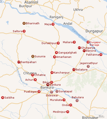 |
| Places in Bankura Sadar subdivision in Bankura district M: municipal town/ city, CT: census town, R: rural/ urban centre, H: hill centre, T: temple, B: barrage Owing to space constraints in the small map, the actual locations in a larger map may vary slightly |
Administrative units
Bankura Sadar subdivision has 9 police stations, 8 community development blocks, 8 panchayat samitis, 75 gram panchayats, 1,384 inhabited villages, 1 municipality and 4 census towns. Bankura is the only municipality in this subdivision. The census towns are: Jhanti Pahari, Barjora, Bhutgerya and Beliatore. The subdivision has its headquarters at Bankura.[3][4]
Police stations
Police stations in Bankura Sadar subdivision have the following features and jurisdiction:[5]
| Police Station | Area covered km2 | Municipal Town | CD Block |
|---|---|---|---|
| Bankura | 439 | Bankura | Bankura I, Bankura II |
| Bankura Sadar Women | – | Bankura | All blocks in Bankura Sadar subdivision |
| Chhatna | 441 | – | Chhatna |
| Saltora | 312.62 | – | Saltora |
| Mejia | 162.90 | – | Mejia |
| Gangajalghati | 371.2 | – | Gangajalghati |
| Barjora | 239.6063 | – | Barjora |
| Beliatore | 222.71 | – | Barjora |
| Onda | 499.41 | – | Onda |
Blocks
Community development blocks in Bankura Sadar subdivision are:[6][7]
| CD Block | Headquarters | Area km2 | Population (2011) | SC % | ST % | Literacy Rate % | Census Towns |
|---|---|---|---|---|---|---|---|
| Bankura I | Puabagan | 171.09 | 107,685 | 37.10 | 6.09 | 68.74 | |
| Bankura II | Bikna | 220.84 | 140,864 | 29.81 | 2.49 | 73.59 | |
| Barjora | Barjora | 393.23 | 202,049 | 33.85 | 1.64 | 71.67 | 3 |
| Chhatna | Chhatna | 447.47 | 195,038 | 29.99 | 20.50 | 65.73 | 1 |
| Gangajalghati | Amarkanan | 366.47 | 180,974 | 35.27 | 3.96 | 68.11 | |
| Mejia | Mejia | 162.87 | 86,188 | 34.19 | 2.45 | 66.83 | |
| Onda | Onda | 502.46 | 252,984 | 33.18 | 4.92 | 65.82 | |
| Saltora | Saltora | 312.62 | 135,980 | 34.19 | 18.90 | 61.45 |
Gram Panchayats
The subdivision contains 75 gram panchayats under eight community development blocks:[8]
- Bankura I block consists of six gram panchayats: Anchuri, Jagadalla–I, Kalapathar, Andharthole, Jagadalla–II and Kenjakura.
- Bankura II block consists of seven gram panchayats: Bikna, Kosthia, Narrah, Sanbandha, Janbedia, Mankanali and Purandarpur.
- Barjora block consists of 11 gram panchayats: Barjora, Chhandar, Hatasuria, Pokhonna, Beliator, Ghutgoria, Khanrari, Shaharjora, Brindabanpur, Godardihi and Maliyara.
- Chhatna block consists of: Arrah, Dhaban, Jirrah, Teghari, Cheenabari, Ghoshergram, Metyala, Chhatna–I, Jamtora, Shaldiha, Chhatna–II, Jhunjhka and Shushunia.
- Gangajalghati block consists of: Banasuria, Gangajalghati, Lachhmanpur, Piraboni, Barashal, Gobindadham, Latiaboni, Bhaktabandh, Kapista and Nityanandapur.
- Mejia block consists of: Ardhagram, Kushtor, Ramchandrapur, Banjora and Mejia.
- Onda block consists of: Chingani, Lodna, Nikunjapur, Ramsagar, Churamonipur, Majdiha, Onda–I, Ratanpur, Kalyani, Medinipur, Onda–II, Santor, Kantabari, Nakaijuri and Punisole.
- Saltora block consists of: Bamuntor, Gogra, Pabra, Saltora, Dhekia, Kanuri, Salma and Tiluri.
Education
Bankura district had a literacy rate of 70.26% as per the provisional figures of the census of India 2011. Bankura Sadar subdivision had a literacy rate of 69.56%, Khatra subdivision 69.79% and Bishnupur subdivision 71.60%. [9]
Given in the table below (data in numbers) is a comprehensive picture of the education scenario in Bankura district for the year 2013–14. It may be noted that primary schools include junior basic schools; middle schools, high schools and higher secondary schools include madrasahs; technical schools include junior technical schools, junior government polytechnics, industrial technical institutes, industrial training centres, nursing training institutes etc.; technical and professional colleges include engineering colleges, medical colleges, para-medical institutes, management colleges, teachers training and nursing training colleges, law colleges, art colleges, music colleges etc. Special and non-formal education centres include sishu siksha kendras, madhyamik siksha kendras, centres of Rabindra mukta vidyalaya, recognised Sanskrit tols, institutions for the blind and other handicapped persons, Anganwadi centres, reformatory schools etc.[9]
| Subdivision | Primary School |
Middle School |
High School |
Higher Secondary School |
General College, Univ |
Technical / Professional Instt |
Non-formal Education | |||||||
|---|---|---|---|---|---|---|---|---|---|---|---|---|---|---|
| Institution | Student | Institution | Student | Institution | Student | Institution | Student | Institution | Student | Institution | Student | Institution | Student | |
| Bankura Sadar | 1,371 | 117,820 | 144 | 17,951 | 90 | 69,329 | 91 | 78,909 | 9 | 14,782 | 14 | 2,865 | 2,228 | 69,919 |
| Khatra | 1,200 | 86,786 | 113 | 16,805 | 50 | 28,178 | 112 | 93,919 | 6 | 13,067 | 6 | 702 | 1,993 | 51,849 |
| Bishnupur | 979 | 86,750 | 112 | 15,092 | 57 | 28,738 | 81 | 78,915 | 6 | 10,552 | 14 | 4,170 | 1,649 | 57,769 |
| Bankura district | 3,550 | 291,356 | 369 | 49,848 | 197 | 126,245 | 284 | 251,743 | 21 | 38,401 | 34 | 7,737 | 5,870 | 179,537 |
Educational institutions
The following institutions are located in Bankura Sadar subdivision:
- Bankura University was established in 2013.[10]
- Bankura Sammilani Medical College at Bankura was started as a medical school in 1922 and was upgraded to a medical college in 1954. The Government of West Bengal took over the institution in 1961. The 131 bedded Bankura district hospital was merged with it in 1964.[11]
- Bankura Unnayani Institute of Engineering at Puabagan, Bankura was established in 1998. It is affiliated to Maulana Abul Kalam Azad University of Technology. It conducts BTech. and MTech courses.[12]
- Bankura Christian College at Bankura was established in 1903 by Weslayan Missionary Society.[13]
- Bankura Sammilani College at Bankura was established in 1948.[14]
- Bankura Zilla Saradamani Mahila Mahavidyapith at Bankura is a women's college established in 1973.[15]
- Saldiha College at Saldiha was established in 1966. It has hostel facilities – three for boys and one for girls.[16]
- Gobindaprasad Mahavidyalaya was established in 1985 at Amarkanan.[17]
- Barjora College at Barjora was established in 1985.[18]
- Jamini Roy College was established at Beliatore in 1986.[19][20]
- Saltora Netaji Centenary College at Saltora was established in 2001.[21]
- Chhatna Chandidas Mahavidyalaya was established at Ghoramuli, Chhatna in 2007.[22]
- Onda Thana Mahavidyalaya was established at PO Murakata in 2007.[23]
- Government General Degree College, Mejia at Gopalpur village, PO Mejia, was established in 2015.[24]
- The College of Agriculture, at Chhatna, an extended campus of Bidhan Chandra Krishi Vishwavidyalaya was started in 2015.[25]
Healthcare
The table below (all data in numbers) presents an overview of the medical facilities available and patients treated in the hospitals, health centres and sub-centres in 2014 in Bankura district.[26]
| Subdivision | Health & Family Welfare Deptt, WB | Other State Govt Deptts |
Local bodies |
Central Govt Deptts / PSUs |
NGO / Private Nursing Homes |
Total | Total Number of Beds |
Total Number of Doctors |
Indoor Patients |
Outdoor Patients | |||
|---|---|---|---|---|---|---|---|---|---|---|---|---|---|
| Hospitals |
Rural Hospitals |
Block Primary Health Centres |
Primary Health Centres | ||||||||||
| Bankura Sadar | 2 | 6 | 2 | 25 | 3 | - | 2 | 31 | 71 | 2,628 | 320 | 147,890 | 2,634,248 |
| Khatra | 1 | 7 | 1 | 21 | - | - | - | 4 | 34 | 698 | 77 | 58,258 | 1,440,172 |
| Bishnupur | 1 | 5 | 1 | 23 | - | - | - | 11 | 41 | 698 | 77 | 68,068 | 1,351,349 |
| Bankura district | 4 | 18 | 4 | 69 | 3 | - | 2 | 46 | 146 | 4,152 | 459 | 274,216 | 5,425,769 |
Medical facilities
Medical facilities in Bankura Sadar subdivision are as follows:
Hospitals: (Name, location, beds) [27]
- Bankura Sammilani Medical College and Hospital, Bankura M, 947 beds
- District Correctional Home Hospital, Bankura M, 8 beds
- Bankura Police Hospital, Bankura M, 20 beds
- Gouripur Leprosy Hospital, Gouripur, 550 beds
- RLTRRI, Gouripur, 50 beds
Rural Hospitals: (Name, CD block, location, beds) [28]
- Gangajalghati (Amar Kanan) Rural Hospital, Gangjalghati CD block, PO Amarkanan, 30 beds
- Anchuri Rural Hospital, Bankura I CD block, Achuri, 30 beds
- Chhatna Rural Hospital, Chhatna CD block, Chhatna, 30 beds
- Saltora Rural Hospital, Saltora CD block, Saltora, 30 beds
- Barjora Rural Hospital, Barjora CD block, Barjora, 30 beds
- Onda Rural Hospital, Onda CD block, PO Medinipurgram, 30 beds
Block Primary Health Centres: (Name, CD block, location, beds)[29]
- Kanchanpur Block Primary Health Centre, Bankura II CD Block, Kanchanpur, 15 beds
- Mejia Block Primary Health Centre, Mejia CD block, Mejia, 25 beds
Primary Health Centres : (CD block-wise)(CD block, PHC location, beds)[30]
- Bankura I CD block: Helna Susunia (10), Kanjakura (10)
- Bankura II CD block: Narrah (4), Mankanali (10)
- Chhatna CD block: Jorhia (10), Salchura (Kamalpur) (2), Jhantipahari (6), Bhagabanpur (6)
- Saltora CD block: Gogra (10), Ituri (Tiluri) (10), Kashtora (6)
- Gangajalghati CD block: Gangajalghati (4), Ramharipur (4), Srichandrapur (10)
- Mejhia CD block: Ramchandrapur (4), Pairasol (10)
- Barjora CD block: Beliatore (10), Chhandar (4), Godardihi (Jagannathpur) (4), Pakhanna (10)
- Onda CD block: Ratanpur (10), Nakaijuri (Ghorasol) (10), Ramsagar (10), Santore (Garh Kotalpur) (10), Nikunjapur (10)
Electoral constituencies
Lok Sabha (parliamentary) and Vidhan Sabha (state assembly) constituencies in Bankura district were as follows:[31]
| Lok Sabha constituency | Vidhan Sabha constituency | Reservation | CD Block and/or Gram panchayats |
|---|---|---|---|
| Bankura | Raghunathpur | SC | In Purulia district |
| Saltora | SC | Saltora and Mejia CD Blocks; Banasuria, Barashal, Lachhmanpur and Latiaboni gram panchayats of Gangajalghati CD Block | |
| Chhatna | None | Chhatna CD Block; Veduasol, Brahmandiha, Hatgram, Indpur and Raghunathpur GPs of Indpur CD Block | |
| Ranibandh | ST | Ranibandh, Hirbandh and Khatra CD Blocks | |
| Raipur | ST | Raipur and Sarenga CD Blocks | |
| Taldangra | None | Bibarda, Fulmati, Harmasra, Khalgram, Panchmura and Taldangra GPs of Taldangra CD Block; Brojarajpur and Gaurbazar gram panchayats of Indpur CD Block; and Simlapal CD Block | |
| Bankura | None | Bankura municipality; Bankura I CD Block; and Junbedia, Mankanali and Purandarpur GPs of Bankura II CD Block | |
| Bishnupur (SC) | Barjora | None | Barjora CD Block; and Bhaktabandh, Gangajalghati, Gobindadham, Kapista, Nityanandapur and Piraboni GPs of Gangajalghati CD Block |
| Onda | None | Onda CD Block; and Bikna, Kosthia, Narrah and Sanbandha GPs of Bankura II CD Block | |
| Bishnupur | Open | Bishnupur municipality; Bishnupur; and Amdangra, Saltora and Satmauli GPs of Taldangra CD Block | |
| Katulpur | SC | Deshrahkoyalpara, Gopinathpur, Kotulpur, Lego, Mirzapur and Sihar GPs of Kotulpur CD Block; Gelia, Jagannathpur, Kuchiakol, Maynapur,
Salda, Uttarbarh, Hetia, Routkhanda and Shyamnagar GPs of Joypur CD Block | |
| Indas | SC | Indas CD Block; Balsi I, Balsi II, Biur Betur, Jamkuri and Kushdwip GPs of Patrasayer CD Block; and Laugram, Madanmohanpur GPs of Kotulpur CD Block | |
| Sonamukhi | SC | Sonamukhi municipality; Sonamukhi CD Block; and Belut Rasulpur, Beersingha, Hamirpur, Narayanpur and Patrasayar GPs of Patrasayer CD Block | |
| Khandaghosh | None | In Bardhaman district | |
References
- "District Statistical Handbook 2014 Bankura". Table 2.2, 2.4(a). Department of Planning and Statistics, Government of West Bengal. Archived from the original on 21 January 2019. Retrieved 15 May 2020.
- "District Statistical Handbook 2014 Bankura". Table 2.2. Department of Planning and Statistics, Government of West Bengal. Archived from the original on 21 January 2019. Retrieved 15 May 2020.
- "District Statistical Handbook 2014 Bankura". Table 2.1. Department of Planning and Statistics, Government of West Bengal. Archived from the original on 21 January 2019. Retrieved 15 May 2020.
- "Directory of District, Sub division, Panchayat Samiti/ Block and Gram Panchayats in West Bengal, March 2008". West Bengal. National Informatics Centre, India. 19 March 2008. Archived from the original on 25 February 2009. Retrieved 9 September 2016.
- "District Statistical Handbook 2014 Bankura". Tables 2.1, 2.2. Department of Planning and Statistics, Government of West Bengal. Archived from the original on 21 January 2019. Retrieved 15 May 2020.
- "Provisional population totals, West Bengal, Table 4, Bankura District". Census of India 2001. Census Commission of India. Archived from the original on 28 September 2011. Retrieved 18 August 2016.
- "C.D. Block Wise Primary Census Abstract Data(PCA)". 2011 census: West Bengal – District-wise CD Blocks. Registrar General and Census Commissioner, India. Retrieved 29 August 2016.
- "Directory of District, Subdivision, Panchayat Samiti/ Block and Gram Panchayats in West Bengal". Bankura – Revised in March 2008. Panchayats and Rural Development Department, Government of West Bengal. Retrieved 27 August 2016.
- "District Statistical Handbook 2014 Bankura". Basic data: Table 4.4, 4.5, Clarifications: other related tables. Department of Planning and Statistics, Government of West Bengal. Archived from the original on 21 January 2019. Retrieved 15 May 2020.
- "Bankura University". Bankura University. Retrieved 14 December 2016.
- "Bankura Sammilani Medical College". BSMC. Retrieved 14 December 2016.
- "Bankura Unnayani Institute of Engineering". BUIE. Retrieved 14 December 2016.
- "Bankura Christian College". BCC. Retrieved 14 December 2016.
- "Bankura Sammilani College". BSC. Retrieved 14 December 2016.
- "Bankura Zilla Saradamani Mahila Mahavidyapith". BZSM College. Archived from the original on 20 December 2016. Retrieved 14 December 2016.
- "Saldiha College". Saldiha College. Retrieved 14 December 2016.
- "Gobinda Prasad Mahavidyalaya". GPV. Retrieved 16 December 2016.
- "Barjora College". Barjora College. Retrieved 14 December 2016.
- "Jamini Roy College". JRC. Retrieved 16 December 2016.
- "Jamini Roy College". College Admission. Retrieved 16 December 2016.
- "Saltora Netaji Centenary College". SNCC. Retrieved 14 December 2016.
- "Chhatna Chandidas Mahavidyalaya". icbse. Retrieved 16 December 2016.
- "Onda Thana Mahavidyalaya". OTM. Retrieved 16 December 2016.
- "Government General Degree College at Mejia (Gopalpur)". GGDC. Archived from the original on 18 February 2017. Retrieved 14 December 2016.
- "Bidhan Chandra Krishi Vishwavidyalaya". Extended campus of BCKV, Bankura, College of Agriculture. BCKV. Retrieved 16 December 2016.
- "District Statistical Handbook 2014 Bankura". Table 3.1, 3.3. Department of Planning and Statistics, Government of West Bengal. Archived from the original on 21 January 2019. Retrieved 15 May 2020.
- "Health & Family Welfare Department" (PDF). Health Statistics - Hospitals. Government of West Bengal. Retrieved 10 April 2020.
- "Health & Family Welfare Department" (PDF). Health Statistics – Rural Hospitals. Government of West Bengal. Retrieved 10 April 2020.
- "Health & Family Welfare Department" (PDF). Health Statistics – Block Primary Health Centres. Government of West Bengal. Retrieved 10 April 2020.
- "Health & Family Welfare Department" (PDF). Health Statistics – Primary Health Centres. Government of West Bengal. Retrieved 10 April 2020.
- "Delimitation Commission Order No. 18 dated 15 February 2006" (PDF). West Bengal. Election Commission of India. Retrieved 24 November 2016.
Cities, towns and locations in Bankura District | |||||||
|---|---|---|---|---|---|---|---|
| Cities, municipal and census towns |
| ||||||
| Locations other than cities and towns |
| ||||||
| Related topics |
| ||||||