Hadal Narayanpur
Hadal Narayanpur are two adjacent villages considered as one in the Patrasayer CD block in the Bishnupur subdivision of the Bankura district in the state of West Bengal, India.
Hadal Narayanpur | |
|---|---|
Village | |
 Hadal Narayanpur Location in West Bengal, India  Hadal Narayanpur Hadal Narayanpur (India) | |
| Coordinates: 23.274694°N 87.523894°E | |
| Country | |
| State | West Bengal |
| District | Bankura |
| Population (2011) | |
| • Total | 1,148+487 |
| Languages | |
| • Official | Bengali, English |
| Time zone | UTC+5:30 (IST) |
| PIN | 722122 |
| Telephone/STD code | 03244 |
| Lok Sabha constituency | Bishnupur |
| Vidhan Sabha constituency | Sonamukhi |
| Website | bankura |
Geography
 |
| Places in Bishnupur subdivision in Bankura district M: Municipal town, CT: census town, R: rural/ urban centre, T: ancient/ temple centre Owing to space constraints in the small map, the actual locations in a larger map may vary slightly |
Location
Hadal Narayanpur is located at 23.274694°N 87.523894°E.
Note: The map alongside presents some of the notable locations in the subdivision. All places marked in the map are linked in the larger full screen map.
Demographics
According to the 2011 Census of India, Narayanpur had a total population of 1,148, of which 590 (51%) were males and 558 (49%) were females. There were 101 persons in the age range of 0–6 years. The total number of literate persons in Narayanpur was 850 (61.18% of the population over 6 years).[1]
According to the 2011 Census of India, Hadal had a total population of 487, of which 255 (52%) were males and 232 (48%) were females. There were 55 persons in the age range of 0–6 years. The total number of literate persons in Balsi Purbapara was 278 (64.35% of the population over 6 years).[2]
Education
Hadal Narayanpur High School is a Bengali-medium coeducational institution established in 1906. It has facilities for teaching from class V to class XII. The school has 10 computers, a library with 1,800 books and a playground.[3]
Patrasayer Mahavidyalaya was established in 2005 at Patrasayer[4][5]
Culture
David J. McCutchion mentions the Radha Damodara temple of the ‘barabari’ as a nava-ratna structure with ridged turrets and rich terracotta façade, built in the 19th century. The rasamancha has rich terracotta on eight sides and the Radha Damodara temple of ‘choto taraf’ as of a modified ratna design, with rich terracotta façade, built in the 19th century.[6]
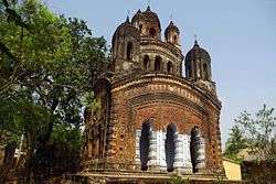 Nava-ratna temple of Mandal family (‘meja taraf’)
Healthcare
Patrasayer Rural Hospital, with 30 beds at Hat Krishnanagar, is the major government medical facility in the Patrasayer CD block.[7]
References
- "CD block Wise Primary Census Abstract Data(PCA)". West Bengal – District-wise CD blocks. Registrar General and Census Commissioner, India. Retrieved 18 April 2020.
- "CD block Wise Primary Census Abstract Data(PCA)". West Bengal – District-wise CD blocks. Registrar General and Census Commissioner, India. Retrieved 18 April 2020.
- "Hadal Narayanpur HS". Schools.org.in. Retrieved 4 May 2020.
- "Patrasayer Mahavidyalaya". Patrasayer Mahavidyalaya. Archived from the original on 6 January 2017. Retrieved 29 November 2016.
- "Patrasayer Mahaviyalaya". College Admission. Retrieved 6 March 2018.
- McCutchion, David J., Late Mediaeval Temples of Bengal, first published 1972, reprinted 2017, pages 24, 39, 75, 77. The Asiatic Society, Kolkata, ISBN 978-93-81574-65-2
- "Health & Family Welfare Department" (PDF). Health Statistics – Rural Hospitals. Government of West Bengal. Retrieved 10 April 2020.
External links
| Wikimedia Commons has media related to Hadal Narayanpur. |
Cities, towns and locations in Bankura District | |||||||
|---|---|---|---|---|---|---|---|
| Cities, municipal and census towns |
| ||||||
| Locations other than cities and towns |
| ||||||
| Related topics |
| ||||||