Bang Klam District
Bang Klam District (Thai: บางกล่ำ, pronounced [bāːŋ klàm]) is a district (amphoe) of Songkhla Province, southern Thailand.
Bang Klam บางกล่ำ | |
|---|---|
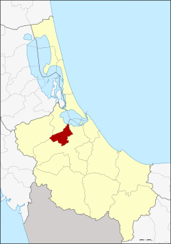 District location in Songkhla Province | |
| Coordinates: 7°5′21″N 100°24′39″E | |
| Country | Thailand |
| Province | Songkhla |
| Seat | Bang Klam |
| Subdistricts | 4 |
| Mubans | 36 |
| District established | 1986 |
| Area | |
| • Total | 147.8 km2 (57.1 sq mi) |
| Population (2014) | |
| • Total | 30,250 |
| • Density | 185.3/km2 (480/sq mi) |
| Time zone | UTC+7 (ICT) |
| Postal code | 90110 |
| Geocode | 9014 |
History
The minor district (king amphoe) was established on 7 January 1986 by splitting off four tambons from Hat Yai District.[1] It was upgraded to a full district on 8 September 1995.[2]
Geography
Neighboring districts are (from the south clockwise): Hat Yai, Rattaphum, and Khuan Niang. To the northeast is the Songkhla lake.
Administration
Central administration
Bang Klam is divided into four sub-districts (tambons), which are further subdivided into 36 administrative villages (mubans).
| No. | Name | Thai | Villages | Pop.[3] |
|---|---|---|---|---|
| 1. | Bang Klam | บางกล่ำ | 7 | 3,718 |
| 2. | Tha Chang | ท่าช้าง | 18 | 20,578 |
| 3. | Mae Thom | แม่ทอม | 6 | 2,277 |
| 4. | Ban Han | บ้านหาร | 5 | 3,677 |
Local administration
There are two sub-district municipalities (thesaban tambons) in the district:
- Tha Chang (Thai: เทศบาลตำบลท่าช้าง) consisting of sub-district Tha Chang.
- Ban Han (Thai: เทศบาลตำบลบ้านหาร) consisting of sub-district Ban Han.
There are two subdistrict administrative organizations (SAO) in the district:
- Bang Klam (Thai: องค์การบริหารส่วนตำบลบางกล่ำ) consisting of sub-district Bang Klam.
- Mae Thom (Thai: องค์การบริหารส่วนตำบลแม่ทอม) consisting of sub-district Mae Thom.
References
- ประกาศกระทรวงมหาดไทย เรื่อง แบ่งเขตท้องที่อำเภอหาดใหญ่ จังหวัดสงขลา ตั้งเป็นกิ่งอำเภอบางกล่ำ (PDF). Royal Gazette (in Thai). 103 (9 ง): 161. January 21, 1986.
- พระราชกฤษฎีกาตั้งอำเภอด่านมะขามเตี้ย อำเภอแก่งหางแมว อำเภอภักดีชุมพล อำเภอเวียงแก่น อำเภอแม่วาง อำเภอถ้ำพรรณรา อำเภอบ่อเกลือ อำเภอโนนสุวรรณ อำเภอห้วยราช อำเภอแม่ลาน อำเภอบางแก้ว อำเภอป่าพะยอม อำเภอหนองม่วงไข่ อำเภอยางสีสุราช อำเภอจังหาร อำเภอบ้านธิ อำเภอภูสิงห์ อำเภอบางกล่ำ อำเภอวังม่วง และอำเภอนายูง พ.ศ. ๒๕๓๘ (PDF). Royal Gazette (in Thai). 112 (32 ก): 1–3. August 8, 1995.
- "Population statistics 2014" (in Thai). Department of Provincial Administration. Retrieved 2015-06-09.
This article is issued from Wikipedia. The text is licensed under Creative Commons - Attribution - Sharealike. Additional terms may apply for the media files.