Bang Kaeo District
Bang Kaeo (Thai: บางแก้ว, pronounced [bāːŋ kɛ̂ːw]) is a district (amphoe) of Phatthalung Province, southern Thailand.
Bang Kaeo บางแก้ว | |
|---|---|
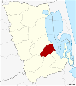 District location in Phatthalung Province | |
| Coordinates: 7°25′48″N 100°10′42″E | |
| Country | Thailand |
| Province | Phatthalung |
| Seat | Na Pakho |
| Area | |
| • Total | 119.0 km2 (45.9 sq mi) |
| Population (2005) | |
| • Total | 25,628 |
| • Density | 215.4/km2 (558/sq mi) |
| Time zone | UTC+7 (ICT) |
| Postal code | 93140 |
| Geocode | 9309 |
Geography
Neighboring districts are (from the south clockwise) Pak Phayun, Pa Bon, Tamot, and Khao Chaison of Phatthalung Province, and Krasae Sin of Songkhla Province.
The eastern part of the district is at the shore of Thale Luang, the northern part of Songkhla Lake.
History
The minor district (king amphoe) was established on 1 April 1990, when three tambon were split off from Khao Chaison District.[1] It was upgraded to a full district on 7 September 1995.[2]
Administration
The district is divided into three sub-districts (tambons), which are further subdivided into 33 villages (mubans). Tha Maduea is a township (thesaban tambon) which covers parts of tambons Tha Maduea and Khok Sak. Another part of Khok Sak belongs to the township Mae Khari, centered in neighboring Tamot District. There are a further three tambon administrative organizations (TAO).
| No. | Name | Thai name | Villages | Pop. | |
|---|---|---|---|---|---|
| 1. | Tha Maduea | ท่ามะเดื่อ | 7 | 7,469 | |
| 2. | Na Pakho | นาปะขอ | 13 | 10,040 | |
| 3. | Khok Sak | โคกสัก | 13 | 8,119 |
References
- ประกาศกระทรวงมหาดไทย เรื่อง แบ่งเขตท้องที่อำเภอเขาชัยสน จังหวัดพัทลุง ตั้งเป็นกิ่งอำเภอบางแก้ว (PDF). Royal Gazette (in Thai). 107 (25 ง): 1354. February 13, 1990.
- พระราชกฤษฎีกาตั้งอำเภอด่านมะขามเตี้ย อำเภอแก่งหางแมว อำเภอภักดีชุมพล อำเภอเวียงแก่น อำเภอแม่วาง อำเภอถ้ำพรรณรา อำเภอบ่อเกลือ อำเภอโนนสุวรรณ อำเภอห้วยราช อำเภอแม่ลาน อำเภอบางแก้ว อำเภอป่าพะยอม อำเภอหนองม่วงไข่ อำเภอยางสีสุราช อำเภอจังหาร อำเภอบ้านธิ อำเภอภูสิงห์ อำเภอบางกล่ำ อำเภอวังม่วง และอำเภอนายูง พ.ศ. ๒๕๓๘ (PDF). Royal Gazette (in Thai). 112 (32 ก): 1–3. August 8, 1995.