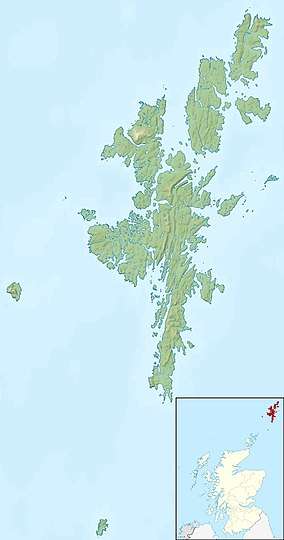
Balta, Shetland
Balta (Old Norse: "Baltey"[5]) is an uninhabited island in Shetland, Scotland.
| Norse name | Baltey |
|---|---|
| Location | |
 Balta Balta shown within Shetland | |
| OS grid reference | HP661081 |
| Coordinates | 60.751°N 0.788°W |
| Physical geography | |
| Island group | Shetland |
| Area | 80 ha (198 acres) |
| Area rank | 162 [1] |
| Highest elevation | 44 m (144 ft) |
| Administration | |
| Sovereign state | United Kingdom |
| Country | Scotland |
| Council area | Shetland Islands |
| Demographics | |
| Population | 0 |
| References | [2][3][4][5] |
 South end of the Isle of Balta and lighthouse | |

| |
| Location | Shetland, Shetland, United Kingdom |
|---|---|
| Coordinates | 60.740416°N 0.794599°W |
| Year first constructed | 1895 (first) |
| Year first lit | 2004 (current) |
| Automated | 2004 |
| Foundation | concrete base |
| Construction | metal skeletal tower (curren) concrete tower (first) |
| Tower shape | quadrangular tower covered by aluminium panels with light on the top (current) cylindrical tower with balcony and lantern (first) |
| Markings / pattern | white tower |
| Tower height | 6.5 metres (21 ft) |
| Focal height | 17 metres (56 ft) |
| Light source | solar power |
| Range | white: 10 nautical miles (19 km; 12 mi) red: 7 nautical miles (13 km; 8.1 mi) [6] |
| Characteristic | Fl WR 10s. |
| Admiralty number | A3828 |
| NGA number | 3524 |
| ARLHS number | SCO-014[7] |
| Heritage | Site of Special Scientific Interest |
Geography
Balta lies off the east coast of Unst and Balta Sound. It has an area of 80 hectares (200 acres).
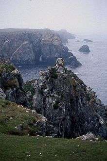
There is a natural arch on the eastern side of the island.
Balta Island Seafare and Skaw Smolts are the most northerly fish farm and fish hatchery in Britain.[8]
History
Historic remains on the island include the ruins of a broch and of a Norse chapel dedicated to Saint Sunniva. There are no census records of more recent inhabitation.[3]
John MacCulloch visited Balta in May 1820 to carry out the Trigonometrical Survey for the Ordnance Survey. Balta was the northernmost station of the zenith sector.[9]
Lighthouse
The Balta Light, at the southern tip of the island was one of the first concrete structures in Shetland. The lighthouse was designed by David Stevenson and built in 1895. It was demolished in 2003 and replaced by a small solar-powered light.[10]
Footnotes
- Area and population ranks: there are c. 300 islands over 20 ha in extent and 93 permanently inhabited islands were listed in the 2011 census.
- National Records of Scotland (15 August 2013) (pdf) Statistical Bulletin: 2011 Census: First Results on Population and Household Estimates for Scotland - Release 1C (Part Two). "Appendix 2: Population and households on Scotland’s inhabited islands". Retrieved 17 August 2013.
- Haswell-Smith, Hamish (2004). The Scottish Islands. Edinburgh: Canongate. ISBN 978-1-84195-454-7.
- Ordnance Survey. "Sheet 1 - Shetland Islands (Yell & Unst) - Ordnance Survey One-inch to the mile maps of Great Britain, Seventh Series, 1952-1961". National Library of Scotland. National Library of Scotland. Retrieved 2016-01-23.
- Anderson, Joseph (ed.) (1873) The Orkneyinga Saga. Translated by Jón A. Hjaltalin & Gilbert Goudie. Edinburgh. Edmonston and Douglas. The Internet Archive. Retrieved 26 August 2013.
- Balta Sound Light Lighthouses Explorer. Retrieved 30 May 2016
- Balta Sound The Lighthouse Directory. University of North Carolina at Chapel Hill. Retrieved 30 May 2016
- "Balta Island Seafare". Archived from the original on 18 February 2008. Retrieved 2008-01-05.
- Derek Flinn (1981). "John MacCulloch, MD, FRS and his Geological Map of Scotland: His Years in the Ordnance. 1795–1826". Notes and Records of the Royal Society of London. London: The Royal Society. 36: 91. doi:10.1098/rsnr.1981.0006. JSTOR 531659.
- Marter, Hans J. (10 November 2003). "Historic lighthouse to go". shetland-news.co.uk/Wayback Machine. Archived from the original on September 27, 2007. Retrieved 15 October 2013.
External links
| Wikimedia Commons has media related to Balta, Shetland Islands. |

| Inhabited islands | ||
|---|---|---|
| Other islands | ||
| Towns and villages | ||
| Points of interest |
| |
| Inhabited islands | ||
|---|---|---|
| Other islands | ||
| Towns and villages | ||
| Mainland Parishes | ||
| Insular Parishes | ||
| Maritime features | ||
Extreme points
| ||
| Topics | ||