Rakaposhi
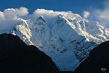
Rakaposhi (Urdu: راکاپوشی) is a mountain in the Karakoram mountain range in the Gilgit-Baltistan territory of Pakistan.[3] It is situated in the middle of the Nagar and Bagrote valleys and danyor , approximately 100 km (62 mi) north of the city of Gilgit. Rakaposhi means "snow covered" in the local language. Rakaposhi is also known as Dumani ("Mother of Mist" or "Mother of Clouds"). It is ranked 27th highest in the world.
| Rakaposhi | |
|---|---|
.jpg) | |
| Highest point | |
| Elevation | 7,788 m (25,551 ft) [1] Ranked 27th |
| Prominence | 2,818 m (9,245 ft) [2] Ranked 122nd |
| Isolation | 41 km (25 mi) |
| Listing | Ultra |
| Coordinates | 36°08′33″N 74°29′21″E [2] |
| Naming | |
| Native name | راکاپوشی (Urdu) |
| Geography | |
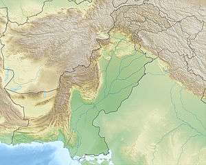 Rakaposhi Location in Gilgit-Baltistan  Rakaposhi Rakaposhi (Gilgit Baltistan) | |
| Location | Nagar Valley, Bagrote valley, Gilgit-Baltistan, Pakistan |
| Parent range | Rakaposhi-Haramosh Mountains, Karakoram |
| Climbing | |
| First ascent | 1958 by Mike Banks and Tom Patey |
| Easiest route | Southwest Spur - glacier/snow/ice |
The first successful recorded ascent by non-natives was in 1958 by Mike Banks and Tom Patey, members of a British expedition, via the Southwest Spur/Ridge route.[4][5] Both of them suffered minor frostbite during the ascent to the summit on June 25. Another climber slipped and fell on the descent and died during the night.
Park
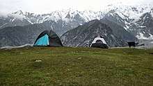
The people of Nagar have dedicated the Rakaposhi range mountain area as a community park. The Minister for Northern Areas inaugurated the park. The Rakaposhi mountain range is the home of endangered species such as Marco Polo sheep, snow leopard, brown bear, and wolves.[6]
Notable features
Rakaposhi is notable for its exceptional rise over local terrain. On the north, it rises 5,900 metres (19,357 ft) in only an 11.2 km (7 mi) horizontal distance from the Hunza-Nagar River. There are views of Rakaposhi from the Karakoram Highway on the route through Nagar. A tourist spot in the town of Ghulmat (located in the Nagar Valley) called "Zero Point of Rakaposhi" is the closest view point of the mountain.
Rakaposhi is the only mountain in the world which rises straight from beautifully cultivated fields to the height of 25,550 feet. From many places this wonderful spectacle can be viewed right from the base to the top.[7]
Time line
- 1892 Martin Conway explores the south side of Rakaposhi.[8]
- 1938 M. Vyvyan and R. Campbell Secord make the first reconnaissance and climb a north-western forepeak (about 5,800 m (19,030 ft)) via the northwest ridge.
- 1947 Secord returns with H. W. Tilman and two Swiss climbers, Hans Gyr and Robert Kappeler; they ascend via the Gunti glacier to 5,800 m (19,000 ft) on the south-west spur.
- 1954 Cambridge University team, led by Alfred Tissières, attempts the peak via the south-west spur but only reached 6,340 m (20,800 ft). Also, an Austro-German expedition led by Mathias Rebitsch attempted the same route.
- 1956 A British-American expedition, led by Mike Banks, reaches 7,163 m (23,500 ft) on the Southwest Ridge, above the Gunti glacier.[8]
- 1958 The first ascent, noted above.
- 1964 An Irish expedition attempts the long and difficult Northwest Ridge.
- 1971 Karl Herrligkofer leads an attempt on the elegant but difficult North Spur (or North Ridge).
- 1973 Herrligkofer returns to the North Spur but is again unsuccessful due to time and weather problems.
- 1979 A Polish-Pakistani expedition ascends the Northwest Ridge from the Biro Glacier.[9]
- 1979 A Japanese expedition from Waseda University, led by Eiho Ohtani, succeeds in climbing the North Spur. Summit party: Ohtani and Matsushi Yamashita. This ascent was expedition-style, done over a period of six weeks, with 5000 m of fixed rope.
- 1984 A Canadian team achieves a semi-alpine-style ascent of the North Spur, using much less fixed rope than the Japanese team had. Summit party: Barry Blanchard, David Cheesmond, Kevin Doyle.[10]
- 1985-1987 Various unsuccessful attempts on the long East Ridge.
- 1986 A Dutch team climbs a variation of the Northwest Ridge route.
- 1995 An ascent via the Northwest Ridge.
- 1997 An ascent via the Southwest Spur/Ridge (possibly the original route).
- 2000 An attempt from the east side Bagrot Valley Hinercha Glacier.
- 2002 A Canadian caliber attempt period of 2 weeks from front side of base camp Hinercha glacier Bagrote valley gilgit east side.
Climbing routes

The routes with successful summits so far have been (see the timeline as well):
- Southwest Spur/Ridge (first ascent route). Long, but not exceedingly technical. Some tricky gendarmes (rock pinnacles). Has been repeated.
- From the east side, it is short route to climb
- Northwest Ridge. Long, and more technically difficult than the Southwest Spur/Ridge. Has been repeated.
- North Spur (a.k.a. North Ridge). Shorter than the above two routes, but much more technically difficult. Has been repeated, including a semi-alpine style (capsule style) ascent.
Attempts have also been made from the east side Bagrot Valley Hinearcha Glacier, the East Ridge, and the North Face.
Gallery
See also
- Highest mountains of the world
- List of Ultras of the Karakoram and Hindu Kush
- List of mountains in Pakistan
References
- "Rakaposhi". Peakbagger.com. Retrieved 25 September 2011.
- "Karakoram ultras". peaklist.org. Retrieved 25 September 2011.
- "Azad_Kashmir.
- Banks, Michael (1959). "Himalaya, Pakistan, Rakaposhi". Climbs And Expeditions. American Alpine Journal. New York, NY, USA: American Alpine Club. 11 (2): 328. Retrieved 2016-06-24.
- "Climbing details". summitpost.org. Retrieved 25 September 2011.
- "Hunza Adventure Tours". HunzaATP.
- Karakuram Hunza: The Land of Just Enough. S. Shahid Hamid. Karachi, 1979, p. 10.
- Irvin, Richard K. (1957). "Rakaposhi — Almost". Feature Article. American Alpine Journal. New York, NY, USA: American Alpine Club. 10 (2): 54. Retrieved 2016-06-24.
- Nyka, Józef (1980). "Rakaposhi, Second Ascent by New Route, Northwest and Southwest Ridges". Climbs And Expeditions. American Alpine Journal. New York, NY, USA: American Alpine Club. Retrieved 2017-10-08.
- Cheesmond, David M. (1985). "The North Face of Rakaposhi". Feature Article. American Alpine Journal. New York, NY, USA: American Alpine Club. 27 (59): 53. Retrieved 2016-06-24.
Sources
- Neate, Jill. High Asia: An Illustrated History of the 7000 Metre Peaks. ISBN 0-89886-238-8.
- Fanshawe, Andy; Venables, Stephen (1995). Himalaya Alpine-Style. Hodder and Stoughton. ISBN 0-89886-456-9.
- Himalayan Index
- DEM files for the Himalaya/Karakoram (Corrected versions of SRTM data)
External links
| Wikimedia Commons has media related to Rakaposhi. |
- Rakaposhi on Summitpost.org
- A list of mountains by local relief and steepness showing Rakaposhi as the world #3.
- Northern Pakistan - highly detailed place marks of towns, villages, peaks, glaciers, rivers and minor tributaries in Google Earth
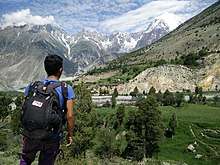
- A Quick approach through lovely meadows leads to the base camp of RAKAPOSHI