Bab-el-Mandeb
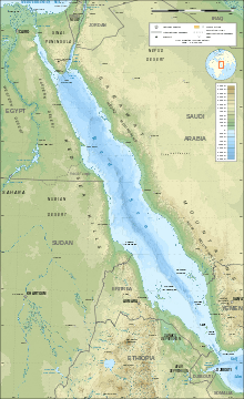
The Bab-el-Mandeb (Arabic: باب المندب, lit. "Gate of Tears")[1] is a strait located between Yemen on the Arabian Peninsula, and Djibouti and Eritrea in the Horn of Africa. It connects the Red Sea to the Gulf of Aden.
| Bab-el-Mandeb | |
|---|---|
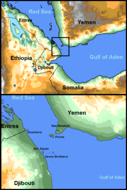 Bab-el-Mandeb area with description. | |
| Coordinates | 12°35′N 43°20′E |
| Basin countries | Djibouti, Eritrea and Yemen |
| Max. length | 31 mi (50 km) |
| Min. width | 16 mi (26 km) |
| Average depth | −609 ft (−186 m) |
| Islands | Seven Brothers, Doumeira, Perim |
Name
The strait derives its name from the dangers attending its navigation or, according to an Arab legend, from the numbers who were drowned by an earthquake that separated the Arabian Peninsula from the Horn of Africa.[1] However modern science dates the rifting of Africa from Arabia to 18 million years before present, long before human beings appeared.[2]
Geography
The Bab-el-Mandeb acts as a strategic link between the Indian Ocean and the Mediterranean Sea via the Red Sea and the Suez Canal. In 2006, an estimated 3.3 million barrels (520,000 m3) of oil passed through the strait per day, out of a world total of about 43 million barrels per day (6,800,000 m3/d) moved by tankers.[3]
The distance across is about 20 miles (30 km) from Ras Menheli in Yemen to Ras Siyyan in Djibouti. The island of Perim divides the strait into two channels, of which the eastern, known as the Bab Iskender (Alexander's Strait), is 2 miles (3 km) wide and 16 fathoms (30 m) deep, while the western, or Dact-el-Mayun, has a width of about 16 miles (25 km) and a depth of 170 fathoms (310 m). Near the coast of Djibouti lies a group of smaller islands known as the "Seven Brothers". There is a surface current inwards in the eastern channel, but a strong undercurrent outwards in the western channel.[1]
History
.png)
Paleo-environmental and tectonic events in the Miocene epoch created the Danakil Isthmus, a land bridge forming a broad connection between Yemen and Ethiopia.[4] During the last 100,000 years eustatic sea level fluctuations have led to alternate opening and closing of the straits.[5] According to the recent single origin hypothesis, the straits of Bab-el-Mandeb were probably witness to the earliest migrations of modern humans. It is presumed that the oceans were then much lower and the straits were much shallower or dry, which allowed a series of emigrations along the southern coast of Asia.
According to Ethiopian Orthodox Tewahedo Church tradition, the straits of Bab-el-Mandeb were witness to the earliest migrations of Semitic Ge'ez speakers into Africa, occurring c. 1900 BC, roughly around the same time as the Hebrew patriarch Jacob.[6] The Kingdom of Aksum was a major regional power in the Horn of Africa. It extended its rule across the strait with the conquest of the Himyarite Kingdom shortly before the rise of Islam.
The British East India Company unilaterally seized the island of Perim in 1799 on behalf of its Indian empire. The government of Britain re-asserted its ownership in 1857 and erected a lighthouse there in 1861, using it to command the Red Sea and the trade routes through the Suez Canal.[1] It was used as a coaling station to refuel steamships until 1935, when the reduced use of coal as fuel rendered the operation unprofitable.[7]
The British presence continued until 1967 when the island became part of the People's Republic of South Yemen. Before the handover, the British government had put forward before the United Nations a proposal for the island to be internationalised[8][9] as a way to ensure continued security of passage and navigation in the Bab-el-Mandeb, but this was refused.
On February 22, 2008, a company owned by Tarek bin Laden unveiled plans to build a bridge named Bridge of the Horns across the strait, linking Yemen with Djibouti.[10] Middle East Development LLC has issued a notice to construct a bridge passing across the Red Sea that would be the longest suspended passing in the world.[11] The project has been assigned to engineering company COWI in collaboration with architect studio Dissing+Weitling, both from Denmark. It was announced in 2010 that Phase 1 had been delayed and as of mid-2016 nothing more has been heard about the project.
Sub-region
The Bab-el-Mandeb is also a sub-region in the Arab League, which includes Djibouti, Yemen, and Eritrea.
Demographics
| Bab-el-Mandeb:[12] | ||||||
| Country | Area (km2) |
Population (2016 est.) |
Population density (per km2) |
Capital | GDP (PPP) $M USD | GDP per capita (PPP) $ USD |
|---|---|---|---|---|---|---|
| 23,200 | 846,687 | 37.2 | Djibouti City | $3.327 | $3,351 | |
| 117,600 | 6,380,803 | 51.8 | Asmara | $9.121 | $1,314 | |
| 527,829 | 27,392,779 | 44.7 | Sana'a | $58,202 | $2,249 | |
| Total | 668,629 | 34,620,269 | 29.3 / km2 | Various | $70,650 | $1841 |
Population centers
The most significant towns and cities along both the Djiboutian and Yemeni sides of the Bab-el-Mandeb
Djibouti
Yemen
References
-

- Horn of Africa#Geography ¶ 2
- World Oil Transit Chokepoints Archived February 18, 2015, at the Wayback Machine, Energy Information Administration, US Department of Energy
- Henri J. Dumont (2009). The Nile: Origin, Environments, Limnology and Human Use. Monographiae Biologicae. 89. Springer Science & Business Media. p. 603. ISBN 9781402097263.
- Climate in Earth History. National Academies. 1982. p. 124.
- Official website of EOTC Archived June 25, 2010, at the Wayback Machine
- Gavin, p. 291.
- Fred Halliday, Revolution and Foreign Policy, the Case of South Yemen, 1967-1987. Cambridge University Press, 1990, p. 11.
- Hakim, pp. 17-18.
- BBC NEWS | Africa | Tarek Bin Laden's Red Sea bridge
- Tom Sawyer (May 1, 2007). "Notice-to-Proceed Launches Ambitious Red Sea Crossing". Engineering News-Record.
- "CIA World Factbook". The World Factbook. Langley, Virginia: Central Intelligence Agency.
External links
| Wikimedia Commons has media related to Bab-el-Mandeb. |
- , Encyclopædia Britannica, 3 (11th ed.), 1911, p. 91
- Notice-to-Proceed Launches Ambitious Red Sea Crossing
- Sea crossing