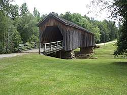
Auchumpkee Creek Covered Bridge
The Auchumpkee Creek Covered Bridge, near Thomaston, Georgia, was built in 1898. It was listed on the National Register of Historic Places in 1975.[1]
Auchumpkee Creek Covered Bridge | |
 | |
 | |
| Nearest city | Thomaston, Georgia |
|---|---|
| Coordinates | 32°45′20″N 84°13′55″W |
| Area | less than one acre |
| Built | 1898 |
| Built by | Herring, Dr. J.W. |
| Architectural style | Town Lattice Truss Bridge |
| NRHP reference No. | 75000614[1] |
| Added to NRHP | April 1, 1975 |
It is a Town lattice truss bridge. It has also been called the Hootenville Covered Bridge.[1]
It is located about 10 miles (16 km) southeast of Thomaston, about 1 mile (1.6 km) off U.S. 19 on Allen Rd.
"It spans Auchumpkee Creek in the Hootenville Militia District of Upson County, Georgia. The bridge is completely covered and extends 120 feet 9 inches in length resting on two native stone piers held together with cement."[2]
References
- "National Register Information System". National Register of Historic Places. National Park Service. November 2, 2013.
- James G. Bogle (November 12, 1974). "National Register of Historic Places Inventory/Nomination: Auchumpkee Creek Covered Bridge". National Park Service. Retrieved September 8, 2018. With accompanying two photos from 1974
| Topics | |
|---|---|
| Lists by state |
|
| Lists by insular areas | |
| Lists by associated state | |
| Other areas | |
| Related | |
| |
This article is issued from Wikipedia. The text is licensed under Creative Commons - Attribution - Sharealike. Additional terms may apply for the media files.