Atmospheric satellite
Atmospheric satellite (United States usage, abbreviated atmosat) or pseudo-satellite (British usage) is a marketing term for an aircraft that operates in the atmosphere at high altitudes for extended periods of time, in order to provide services conventionally provided by an artificial satellite orbiting in space.
Atmospheric satellites remain aloft through atmospheric lift, either aerostatic/buoyancy (e.g., balloons) or aerodynamic (e.g., airplanes). By contrast, conventional satellites in Earth orbit operate in the vacuum of space and remain in flight through centrifugal force derived from their orbital speed.
To date, all atmosats have been unmanned aerial vehicles (UAVs).
Design principles
Overview
An atmosat remains aloft through atmospheric lift, in contrast to a satellite in Earth orbit which moves freely at high speed in the vacuum of space, and orbits due to its centrifugal force matching the force of gravity. Satellites are expensive to build and launch, and any changes to their orbit requires expending their extremely limited fuel supply. Atmospheric satellites fly much slower and are intended to provide a range of services more economically and with more versatility than current low Earth orbit satellites.[1]
Operating altitudes are expected to be in the tropopause—at approximately 65,000 feet—where winds are generally less than 5 knots and clouds do not block sunlight.[2] It is desirable in the United States to operate above 60,000 feet, above which the Federal Aviation Administration does not regulate the airspace.[2]
There are two classes of atmosat, respectively gaining their lift through either aerostatic (e.g., balloons) or aerodynamic (e.g., airplanes) forces. In order to remain aloft for long periods, the NASA and Titan Aerospace designs use propeller-driven electric airplanes powered by solar cells, in contrast to Google's Project Loon which envisions using helium-filled high-altitude balloons.[1][3]
Airplanes
To enable night time operation and ensure endurance through consecutive 24-hour day/night cycles, in daylight hours solar panels charge batteries[2] or fuel cells[4] which subsequently power the vehicle during hours of darkness. An atmospheric satellite may initially ascend at night under battery power, and reach altitude soon after dawn to allow solar panels to take advantage of a full day's sunlight.[1]
Facebook's UAV-based Aquila system expects to use laser communication technology to provide Internet communication among UAVs, and also between UAVs and ground stations that in turn will connect to rural areas.[5] The Aquila UAV is a carbon fiber, solar-powered flying wing design about the size of a passenger jet.[5][6] Aquila's first test flight took place on June 28, 2016.[6] It flew for ninety minutes, reaching a maximum altitude of 2150 feet,[7] and was substantially damaged when a twenty-foot section of the righthand wing broke off during final approach to landing.[8][9] The Aquila is designed and manufactured by the UK company Ascenta.[10]
Luminati Aerospace claims its Substrata solar-powered aircraft could remain aloft indefinitely up to a latitude of 50° through formation flight like migratory geese, reducing by 79% the power required for the trailing aircraft and allowing smaller airframes.[11]
Balloons

A geostationary balloon satellite (GBS) flies in the stratosphere (60,000 to 70,000 feet (18 to 21 km) above sea level) at a fixed point over the Earth's surface. At that altitude the air has 1/10 of its density is at sea level. The average wind speed at these altitudes is less than that at the surface.
A GBS could be used to provide broadband Internet access over a large area.[12][13][14]
One current project is the Google's Project Loon, which envisions using helium-filled high-altitude balloons.
Applications
Proposed applications for atmosats include border security, maritime traffic monitoring, anti-piracy operations, disaster response, agricultural observation, atmospheric observation, weather monitoring, communications relay, oceanographic research, Earth imaging and telecommunications.[2] Facebook is reportedly envisioning providing Internet access to the African continent with a fleet of 11,000 vehicles.[1]
High-Altitude Long Endurance
High-Altitude Long Endurance (HALE) is the description of an air-borne vehicle which functions optimally at high-altitude (as high as 60,000 feet)[15] and is capable of flights which last for considerable periods of time without recourse to landing. The Tropopause represents high-altitude.[16]
Craft
Lockheed-Martin have produced a HALE Demonstrator, which was the first of this type of craft. The HALE-D vehicle was launched during July the 27th 2011 to operate from a location which is higher than the jet-stream in a geostationary position. The HALE-D was to function as a surveillance platform, telecommunications relay, or a weather observer.[17]
Armstrong Flight Research Center have a HALE known as Global Hawk. The craft was used in a year 2014 Airborne Tropical Tropopause Experiment. The craft was created and developed by Northrop Grumman. The capacity for Long-endurance for this craft is 24 hours operational time.[18]
[19] BAYRAKTARs AKINCI was produced as a HALE class UAV and is set to go into service in 2021 or late 2020
Proteus High-Altitude Aircraft operates at heights of 19 kilometres and 812 metres (65,000 ft), while carrying a 1,100 kg weight, with an endurance time of 18 hours maximum.[20]
Altus II, (Latin: Altus meaning High) runs at heights of 18 kilometres and 288 metres (60,000 feet) plus, with endurance times of 24 hours approximately, with variations of capabilities of endurance dependent on the altitude of operation.[21]
Boeing Phantom Eye [22] is able to maintain flight at altitude for four days with a payload; a design variant is able to maintain flight at altitude for ten days, while carrying a payload.[23][24]
A design paper (Z. Goraj et al 2004) describes the HALE PW-114 craft, equipped with sensors to fly at a height of 20 kilometres for a duration of 40 hours.[25]
RQ-3A DarkStar is a high-stealth oriented craft built to function optimally within highly defended areas, in order to make reconnaissance. The craft is intended to hover over targets for a period of time of at least eight hours, at heights of 13.716 kilometres (45,000 feet) and beyond.[25][26][27]
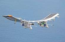
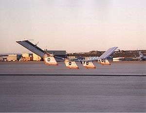
Airbus Zephyr was designed to fly at a maximum height of altitude 21.336 kilometres (70 000 feet), and in a 2006 flight, was airborne for 80 hours, which was then was the longest flight made by a HALE vehicle.[28] Model 7 holds the official long-endurance record for an UAV of 336 hours, 22 minutes and 8 seconds, a flight made from the 9th to the 23rd of July 2010.[29][30]
A160 Hummingbird is a rotorcraft produced by Boeing.[31]
Guizhou Soar Dragon, produced by Chengdu Aircraft Industry Group is a HALE UAV used for military reconnaissance, with a service ceiling of 18,000 m and range or 7,000 km.
The Divine Eagle, produced by Shenyang Aircraft Corporation, is a large HALE UAV with an extremely large wingspan, and designed for cruising at very high altitude. It is a Twin-boom aircraft. It is speculated to carry a series of airborne early warning radars of the Active electronically scanned array type, and notably with some anti-stealth capability. During its development, it was designated an "anti stealth UAV". It is one of a series of SYAC UAV.
Northrop Grumman RQ-4 Global Hawk is a high-altitude remotely-piloted surveillance aircraft.
High-altitude platform station
High-altitude platform station or High-Altitude Pseudo-Satellite (short: HAPS) or High-Altitude Platform (short: HAP or HAPs[plural]) is – according to Article 1.66A of the International Telecommunication Union's (ITU) ITU Radio Regulations (RR)[32] – defined as "a station on an object at an altitude of 20 to 50 km and at a specified, nominal, fixed point relative to the Earth".
Each station shall be classified by the service in which it operates permanently or temporarily.
- See also
Design considerations
Limitation due to power
A HAP can be a manned or unmanned airplane, a balloon, or an airship. All require electrical power to keep themselves and their payload functional. While current HAPS are powered by batteries or engines, mission time is limited by the need for recharging/refueling. Therefore, alternative means are being considered for the future. Solar cells are one of the best options currently being used under trial for HAPS (Helios, Lindstrand HALE).[33]
Altitude selection for HAPS

Whether an airship or an aeroplane, a major challenge is the ability of the HAP to maintain stationkeeping in the face of winds. An operating altitude between 17 and 22 km is chosen because in most regions of the world this represents a layer of relatively mild wind and turbulence above the jet stream. Although the wind profile may vary considerably with latitude and with season, a form similar to that shown will usually obtain. This altitude (> 17 km) is also above commercial air-traffic heights, which would otherwise prove a potentially prohibitive constraint.[34]
Comparison to satellites
Since HAPS operate at much lower altitudes than satellites, it is possible to cover a small region much more effectively. Lower altitude also means much lower telecommunications link budget (hence lower power consumption) and smaller round-trip delay compared to satellites. Furthermore, deploying a satellite requires significant time and monetary resources, in terms of development and launch. HAPS, on the other hand, are comparatively less expensive and are rapidly deployable. Another major difference is that a satellite, once launched, cannot be landed for maintenance, while HAPS can.[35]
Applications
Telecommunications
One of the latest uses of HAPS has been for radiocommunication service. Research on HAPS is being actively carried largely in Europe, where scientists are considering them as a platform to deliver high-speed connectivity to users, over areas of up to 400 km. It has gained significant interest because HAPS will be able to deliver bandwidth and capacity similar to a broadband wireless access network (such as WiMAX) while providing a coverage area similar to that of a satellite.
High-altitude airships can improve the military's ability to communicate in remote areas such as those in Afghanistan, where mountainous terrain frequently interferes with communications signals.[36]
Surveillance and intelligence
One of the best examples of a high-altitude platform used for surveillance and security is Northrop Grumman RQ-4 Global Hawk UAV used by the US Air Force. It has a service ceiling of 20 km and can stay in the air for continuous 36 hours. It carries a highly sophisticated sensor system including radar, optical, and infrared imagers. It is powered by a turbofan engine and is able to deliver digital sensor data in realtime to a ground station.[37]
Real-time monitoring of a region
Another future use that is currently being investigated is monitoring of a particular area or region for activities such as flood detection, seismic monitoring, remote sensing and disaster management.[38]
Weather and environmental monitoring
Perhaps the most common use of high-altitude platforms is for environment/weather monitoring. Numerous experiments are conducted through high-altitude balloons mounted with scientific equipment, which is used to measure environmental changes or to keep track of weather. Recently, NASA in partnership with The National Oceanic and Atmospheric Administration (NOAA), has started using Global Hawk UAV to study Earth's atmosphere.[39]
As a rocket launch platform
Due to the height, more than 90% of atmospheric matter is below the high-altitude platform. This reduces atmospheric drag for starting rockets. "As a rough estimate, a rocket that reaches an altitude of 20 km when launched from the ground will reach 100 km if launched at an altitude of 20 km from a balloon."[40] Such a platform has been proposed to allow the usage of (long) mass drivers for launching goods or humans into orbit.[41]
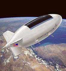
Lockheed-Martin High-Altitude Airship (HAA)
The United States Department of Defense Missile Defense Agency contracted Lockheed Martin to construct a High-Altitude Airship (HAA) to enhance its Ballistic Missile Defense System (BMDS).[42]
An unmanned lighter-than-air vehicle, the HAA was proposed to operate at a height of above 60,000 feet (18,000 m) in a quasi-geostationary position to deliver persistent orbital station keeping as a surveillance aircraft platform, telecommunications relay, or a weather observer. They originally proposed to launch their HAA in 2008. The airship would be in the air for up to one month at a time and was intended to survey a 600-mile (970 km) diameter of land. It was to use solar cells to provide its power and would be unmanned during its flight. The production concept would be 500 feet (150 m) long and 150 feet (46 m) in diameter. To minimize weight. it was to be composed of high strength fabrics and use lightweight propulsion technologies.
A subscale demonstrator unit for this project, the "High Altitude Long Endurance-Demonstrator" (HALE-D),[36] was built by Lockheed Martin and launched on a test flight on July 27, 2011 to demonstrate key technologies critical to the development of unmanned airships. The airship was supposed to reach an altitude of 60,000 feet (18,000 m), but a problem with the helium levels[43] occurred at 32,000 feet (9,800 m) which prevented it from reaching its target altitude, and the flight was terminated. It descended and landed at a speed of about 20 feet per second[43] in a heavily forested area in Pennsylvania.[44] Two days after the landing, before the vehicle was recovered from the crash site, the vehicle was destroyed by fire.[45]
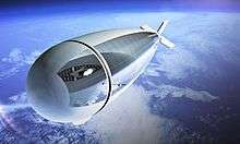
Stratospheric airship
A stratospheric airship is a powered airship designed to fly at very high altitudes 30,000 to 70,000 feet (9.1 to 21.3 kilometres). Most designs are remote-operated aircraft/unmanned aerial vehicles (ROA/UAV). To date none of these designs have received approval from the FAA to fly in U.S. airspace.
Stratospheric airship efforts are being developed in at least five countries.[46]
The first stratospheric powered airship flight took place in 1969, reaching 70,000 feet (21 km) for 2 hours with a 5 pounds (2.3 kilograms) payload.[47] On December 4, 2005 a team led by Southwest Research Institute (SwRI), sponsored by the Army Space and Missile Defense Command (ASMDC), successfully demonstrated powered flight of the HiSentinel stratospheric airship at an altitude of 74,000 feet (23 km).[48] [49] Japan[50] and South Korea are also planning to deploy HAAs. South Korea has been conducting flight tests for several years with a vehicle from Worldwide Aeros.[51]
Aircraft
In January 2018, several systems were in development:[52]
- AeroVironment will design and development solar-powered UAV prototypes for $65 million for HAPSMobile, a joint venture 95% funded and owned by Japanese telco SoftBank; its 247 ft (75 m)-span Helios Prototype first flew in 1999 and reached 96,863 ft (29,524 m) in 2001 before breaking up in flight in 2003; in 2002, its 121 ft (37 m)-span Pathfinder Plus carried a communications payload to FL650; its hydrogen-powered Global Observer designed to stay aloft a week in the stratosphere first flew in 2010 but crashed in 2011;
- Airbus builds the Zephyr, spanning 80 ft (24 m) and weighing less than 100 lb (45 kg), it is designed to stay aloft for months; a 2010 version flew for 14 days, while in July 2018, a Zephyr flew continuously for 25 days, 23 hours, and 57 minutes;[53]
- Facebook worked on developing the Aquila solar-powered high-altitude flying-wing UAV to provide internet connectivity, spanning 132 ft (40 m) and weighing 935 lb (424 kg). It made two low-altitude test flights in 2016 and 2017 and is designed to stay aloft at FL650 for 90 days. On June 27, 2018 Facebook announced it will halt the project and plan to have other companies build the drones.[54]
- Thales Alenia Space develops the Stratobus unmanned, solar-powered stratospheric airship, 377 ft (115 m) long and weighting 15,000 lb (6,800 kg) including a 550 lb (250 kg) payload, it is designed for a five-year mission with annual servicing and a prototype is planned for late 2020
- China Aerospace Science and Technology Corporation flew a 147 ft (45 m)-span solar-powered UAV to FL650 in a 15 hours test flight in July 2017
- Russia's Lavochkin design bureau is flight-testing the LA-252, an 82 ft (25 m)-span, 255 lb (116 kg) solar-powered UAV designed to stay aloft 100 days in the stratosphere.
UK mapping agency Ordnance Survey (OS), a subsidiary of the Department for Business, Energy & Industrial Strategy, is developing the A3, a 38 m (125 ft) wingspan, 149 kg (330 lb) twin-boom solar-powered HAPS designed to stay aloft at 67,000 ft (20,000 m) for 90 days carrying a 25 kg (55 lb) payload. OS owns 51% of UK company Astigan, led by Brian Jones, developing the A3 since 2014 with scale model test flights in 2015 and full-scale low-altitude flights in 2016. High-altitude flights should begin in 2019, to complete tests in 2020 with a commercial introduction as for environmental monitoring, mapping, communications and security.[55]
Designed by Prismatic Ltd., now BAE Systems, the 35 m (115 ft)-wingspan PHASA-35 made its maiden flight in February 2020 from the Woomera Test Range in South Australia; it should fly its 15 kg (33 lb) payload at around 70,000 ft for days or weeks.[56]
History
HALE
The idea of HALE was acknowledged in technical papers as early as 1983, with A preliminary study of solar powered aircraft and associated power trains written by D.W. Hall, C.D. Fortenbach, E.V. Dimiceli and R.W. Parks (NASA CR-3699),[57] the actual state of affairs within technology of a time during the 1970s, allowed for scientists to later consider the possibility of Long endurance flight as a conceivable inclusion to aviation of suborbital spacecraft.[58] One of the first papers to explicitly mention Long Endurance is J.W.Youngblood, T.A. Talay & R.J. Pegg Design of Long Endurance Unmanned Airplanes Incorporating Solar and fuel cell propulsion, published 1984.[57] An early paper which incorporates both high-altitude and long-endurance as the area of investigation, is M.D. Maughmer (University Pennsylvania State) and D.M. Somers (NASA Langley) Design and experimental results for a high-altitude, long-endurance airfoil. The authors state interest in development of such a craft lay in the need to fulfill communication relay missions, weather monitoring, and to obtain information for the targeting of cruise missiles. This paper was published in the year 1989.[59]
The research paper, 2025, written by B.W. Carmichael (Colonel), and Majors, T.E. DeVine, R.J. Kaufman, P.E. Pence and R.E. Wilcox, and presented July 1996, foresaw routine HALE-UAV operations happening within the early 21st century. In contemplation of a future of the military, projected to 2025, the authors thought a HALE in flight for 24 hours. Long endurance ("long-loiter") is held synonymous with the concept of maintaining air occupation, "the ability to hold an adversary continuously at risk from lethal and non-lethal effects from the air".[60]
The Defense Airborne Reconnaissance Office at some time made demonstrations of long-endurance UAV craft.[60]
G Frulla (Turin, Italy 2002) wrote a paper on very long endurance.[61]
An important goal of the CAPECON project, instigated by the European Union, was the development of HALE vehicles.[25]
NASA ERAST Program
The initial goals under the NASA's Environmental Research Aircraft and Sensor Technology (ERAST) project were to demonstrate sustained flight at an altitude near 100,000 feet and flying non-stop for at least 24 hours, including at least 14 hours above 50,000 feet.[4] The early development path of atmospheric satellites included the NASA Pathfinder (exceeding 50,000 feet in 1995), the Pathfinder Plus (80,000 feet in 1998), and the NASA Centurion which was modified into a prototype configuration for the NASA Helios (96,000 feet in 2001).[4] An Airbus/Qinetiq Zephyr flew for 14 days in the summer of 2010, and in 2014 a Zephyr 7 stayed up for 11 days in the short days of winter whilst carrying a small payload for the British Ministry of Defence.[62]
See also
- Geostationary satellite
- Geostationary balloon satellite
- High-altitude platform station
- High-altitude balloon
- Boeing Insitu ScanEagle
- ThothX Tower
- 21st Century Airships
- Integrated Sensor is Structure
- Long Endurance Multi-intelligence Vehicle
- Myasishchev M-55
- TCOM Blue Devil
- Tethered blimp
References
- Perez, Sarah; Constine, Josh (March 4, 2014). "Facebook In Talks To Acquire Drone Maker Titan Aerospace". TechCrunch. Archived from the original on March 4, 2014.
- Dillow, Clay (August 23, 2013). "The drone that may never have to land". Fortune (CNN). Archived from the original on March 9, 2014.
- Google Buys Solar-Powered Drones to Expand Internet Access, Accessed April 22, 2014
- "NASA Armstrong Fact Sheet: Helios Prototype". NASA. February 28, 2014. Archived from the original on March 9, 2014.
- Perry, Tekla S. (April 13, 2016). "Facebook's Aquila Drone Creates a Laser-net In the Sky". IEEE Spectrum. Archived from the original on April 14, 2016. ● Gershgorn, Dave (February 23, 2016). "Facebook's Enormous Internet Drone is Almost Ready for Primetime". Popular Science. Archived from the original on April 19, 2016.
- Metz, Cade (21 July 2016). "Facebook's Giant Internet-Beaming Drone Finally Takes Flight". Wired. Retrieved 2016-07-21.
- Newton, Casey (2016-12-16). "Facebook's drone test flight ended with part of the wing snapping off". The Verge. Retrieved 2016-12-17.
- "DCA16CA197". www.ntsb.gov. Retrieved 2016-12-17.
- "Reviewing Aquila's first full-scale test flight". Facebook Code. Retrieved 2016-12-17.
- Rory Cellan-Jones; Facebook's drones - made in Britain, BBC, 21 July 2016. (Retrieved 24 July 2016).
- Mark Huber (August 2, 2018). "Luminati: Perpetual Solar-powered Flight Possible". AIN online.
- Izet-Unsalan, Kunsel; Unsalan, Deniz (2011). "A low cost alternative for satellites- tethered ultra-high altitude balloons". Proceedings of 5th International Conference on Recent Advances in Space Technologies - RAST2011. ieeexplore.ieee.org. pp. 13–16. doi:10.1109/RAST.2011.5966806. ISBN 978-1-4244-9617-4.
- Chong-Hung Zee (1989). "The Use of Balloons for Physics and Astronomy". Theory of Geostationary Satellites. Springer Science & Business Media. p. 166. ISBN 978-90-277-2636-0.
- "NOAA's Geostationary and Polar-Orbiting Weather Satellites". noaasis.noaa.gov. Archived from the original on 25 August 2018. Retrieved 24 March 2014.
- https://defensesystems.com/articles/2015/05/27/uas-male-vs-hale-debate.aspx
- AUVSI Review - 2007 published by Defense Update magazine [Retrieved 2015-12-09]
- profile published by Lockheed Martin Corporation 2015 [Retrieved 2015-12-09]
- Factsheet published by NASA February 28, 2014 (& August 6, 2015) Editor: Monroe Conner [Retrieved 2015-12-09]
- https://www.ainonline.com/aviation-news/defense/2019-12-11/turkeys-new-raider-takes-air
- Factsheet published by NASA February 28, 2014 (& August 10, 2015) Editor: Yvonne Gibbs [Retrieved 2015-12-09]
- Factsheet published by NASA February 28, 2014 (& July 31, 2015) Editor: Yvonne Gibbs [Retrieved 2015-12-09]
- J. Meister - News page published by pddnet 2015 [Retrieved 2015-12-10]
- Boeing - profile [Retrieved 2015-12-10]
- G. Jennings - report published by IHS Jane's Defence Weekly June 15, 2015 [Retrieved 2015-12-10]
- Z. Goraj; A. Frydrychewicz; R. Świtkiewicz; B. Hernik; J. Gadomski; T. Goetzendorf-Grabowski; M. Figat; St Suchodolski; W. Chajec. report (PDF). Bulletin of the Polish Academy of Sciences, Technical Sciences, Volume 52. Number 3, 2004. Retrieved 2015-12-09.
- F.A.S. - Document published by the Federation of American Scientists [Retrieved 2015-12-10]
- F.A.S. Intelligence Resource program - document published by the Federation of American Scientists [Retrieved 2015-12-10]
- A. Rapinett - Dissertation published by the University of Surrey (Physics Dept.) April 2009 [Retrieved 2015-12-10]
- Amos, Jonathan (2010-07-23). "'Eternal plane' returns to Earth". BBC News. Retrieved 2010-07-23.
touched down at 1504 BST ... on Friday ... took off ... at 1440 BST (0640 local time) on Friday, 9 July
- "FAI Record ID No. 16052". Fédération Aéronautique Internationale. Retrieved 4 December 2012.
- Vertical magazine. News. published by MHM publishing October 28, 2005. Retrieved 2015-12-12.
- ITU Radio Regulations, Section IV. Radio Stations and Systems – Article 1.66A, definition: high altitude platform station
- "HALE Airship" (PDF). Archived from [http%3A//www.ssd.rl.ac.uk/Appleton_Space_Conference/Pattinson.pdf the original] Check
|url=value (help) (PDF) on 2011-05-11. - High-altitude platforms for wireless communications by T. C. Tozer and D. Grace, Electronics & Communication Engineering Journal, June 2001
- Archived November 1, 2006, at the Wayback Machine
- "High Altitude Airship". Lockheed Martin. 2012-03-06. Retrieved 2016-03-25.
- Global Hawk, Federation of American Scientists.
- The airborne Remote Sensing technical system of the Chinese Academy of Sciences by Tong Qingxi, The Joint Center for Remote Sinsing of CAS China.
- NASA Recruits Unmanned Aircraft for Earth Science, Space.com.
- Nobuyuki Yajima; Naoki Izutsu; Takeshi Imamura; Toyoo Abe (2004). "3.7.2.3 Launching Rockets from Ballons (Rockoons)". Scientific Ballooning. Springer. p. 162. doi:10.1007/978-0-387-09727-5. ISBN 978-0-387-09725-1.
- Gerard K. O'Neill (1981). 2081: a hopeful view of the human future.
- "High Altitude Airship (HAA)". Lockheed Martin. Archived from the original on 2010-11-14. Retrieved 2010-11-08.
- Jim Mackinnon, "Lockheed Martin’s prototype blimp crashes during maiden voyage", Akron Beacon Journal, ,July 27, 2011 (accessed 25 March 2016)
- "HALE-D flight aborted". Lighter-Than-Air Society. July 27, 2011.
- Jim Mackinnon, "Lockheed Martin’s prototype airship burns", Akron Beacon Journal, August 2, 2011 (accessed 25 March 2016)
- "Airships: Making a Comeback". Aviation Today. 1 April 2004. Retrieved 2010-11-08.
- "Aerostar International, Station Keeping Airships". Archived from the original on 2010-01-15. Retrieved 2010-11-08.
- "Southwest Research Institute News". 17 November 2005. Retrieved 2010-11-08.
- "Raven Industries Announces Historic Five-Hour Flight of 'HiSentinel' Powered Stratospheric Airship". November 18, 2005. Archived from the original on May 12, 2017. Retrieved November 16, 2019.
- "Expectations soar for our huge new airship". Japan Aerospace Exploration Agency. 2007. Retrieved 2010-11-08.
- "South Korean High-Altitude Airship (HAA) Envelope Test". Worldwide Aeros Corp. 30 August 2002. Archived from the original on 21 November 2008. Retrieved 2010-11-08.
- Graham Warwick (Jan 12, 2018). "AeroVironment's Stratospheric Satellites Persistence Pays Off". Aviation Week & Space Technology.
- Mark Schauer (ATEC) (February 12, 2019) Unmanned aircraft stays aloft for nearly 26 days above U.S. Army Yuma Proving Ground
- https://code.fb.com/connectivity/high-altitude-connectivity-the-next-chapter/
- Tony Osborne (Feb 18, 2019). "The Week In Technology, Feb. 18-22, 2019". Aviation Week & Space Technology.
- Dan Thisdell (17 February 2020). "BAE joins high-altitude race with maiden PHASA-35 flight". Flightglobal.
- C.L. Nickol; M.D.Guynn; L.L. Kohout; T.A. Ozorovski. High Altitude Long Endurance Air Vehicle Analysis of Alternatives and Technology Requirements Development (PDF) (Report). NASA. Retrieved 2015-12-09.
- D.W. Hall et al - report 3699 prepared for Langley Research Centre published December 1983 [Retrieved 2015-12-09]
- M.D. Maughmer and D.M. Somers - Design and experimental results for a high-altitude, long-endurance airfoil Journal of Aircraft Vol. 26, No. 2 (1989) doi: 10.2514/3.45736 (American Institute of Aeronautics and Astronautics Association) [Retrieved 2015-12-09]
- B.W. Carmichael; T.E. DeVine; R.J. Kaufman; P.E. Pence; R.E. Wilcox. Strikestar 2025 (PDF) (Report). The U.S. Air-force August 1996. Archived from the original (PDF) on 2015-12-10. Retrieved 2015-12-10.
- G Frulla - Proceedings of the Institution of Mechanical Engineers, Part G: Journal of Aerospace Engineering April 1, 2002 vol. 216 no. 4 189-196 published by Journal of Aerospace Engineering doi: 10.1243/09544100260369722 [Retrieved 2015-12-09]
- Tovey, Alan (31 August 2014). "Fly 11 days non-stop? Now that's long-haul". Daily Telegraph.
Bibliography
C. Smith - article published by The Examiner (AXS Digital Group LLC) March 8, 2010 [Retrieved 2-15-12-09]
External links
- Mobile Telecommunications via Stratosphere by R. Struzak
- HAA page at Global Security
- HAA contract info