Animas, New Mexico
Animas is an unincorporated community and census-designated place (CDP) in west-central Hidalgo County, New Mexico, United States, in the southwestern corner of the state. As of the 2010 census it had a population of 237.[1]
Animas, New Mexico | |
|---|---|
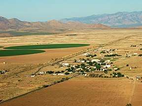 Aerial view | |
 Animas  Animas | |
| Coordinates: 31°56′56″N 108°48′26″W | |
| Country | United States |
| State | New Mexico |
| County | Hidalgo |
| Area | |
| • Total | 15.7 sq mi (40.6 km2) |
| • Land | 15.7 sq mi (40.6 km2) |
| • Water | 0.0 sq mi (0.0 km2) |
| Elevation | 4,406 ft (1,343 m) |
| Population (2010) | |
| • Total | 237 |
| • Density | 15/sq mi (5.8/km2) |
| Time zone | UTC-7 (Mountain (MST)) |
| • Summer (DST) | UTC-6 (MDT) |
| ZIP Code | 88020 |
| Area code(s) | 575 |
| FIPS code | 35-03750 |
| GNIS feature ID | 0885759 |
It lies at the intersection of State Roads 9 and 338, south of the city of Lordsburg, the county seat.[2] Its elevation is 4,406 feet (1,343 m), and it is located at 31°56′56″N 108°48′26″W (31.9489799, -108.8072777).[3] Although Animas is unincorporated, it has a post office which opened in 1909.[4] The community has the ZIP code of 88020.[5]
History
Founded around 1753 by the Spanish,[6] Animas became part of the newly independent country of Mexico in 1821.[7] Unlike most of New Mexico, Animas was not part of the Mexican Cession after the Mexican–American War ended; it is located in the area sold to the United States with the Gadsden Purchase of 1853.[8]
Geography
Animas is an isolated ranching community. It is located in the valley bounded by the Peloncillo Mountains on the west and the Pyramid Mountains and Animas Mountains on the east. It is situated just west of the Continental Divide[2] and is approximately 30 miles (48 km) south of Lordsburg, the nearest significant population center.[6] Smaller communities closer to Animas include Cotton City, Playas, and Rodeo.[2] Animas lies in a region rich in Native American history—twenty-one different archeological sites in the Animas area are listed on the National Register of Historic Places.[9]
According to the U.S. Census Bureau, the Animas census-designated place has an area of 15.7 square miles (40.6 km2), all of it land.[1]
References
- "Geographic Identifiers: 2010 Census Summary File 1 (G001): Animas CDP, New Mexico". American Factfinder. U.S. Census Bureau. Archived from the original on February 13, 2020. Retrieved August 24, 2017.
- Rand McNally. The Road Atlas '09. Chicago: Rand McNally, 2009, 68.
- U.S. Geological Survey Geographic Names Information System: Animas, New Mexico
- U.S. Geological Survey Geographic Names Information System: Animas Post Office
- Zip Code Lookup Archived June 15, 2011, at the Wayback Machine
- Johnson, Donna. Animas, Cotton City, and Playas — remnants of the Westward Ho! movement Archived August 13, 2004, at the Wayback Machine, southernnewmexico.com, 2002-12-30. Accessed 2009-06-03.
- Chasteen, John Charles. Born in Blood and Fire: A Concise History of Latin America. New York: Norton, 2001, 109. ISBN 978-0-393-97613-7
- Desert Diary: History/Gadsden Purchase Archived January 8, 2009, at the Wayback Machine, University of Texas at El Paso. Accessed 2009-06-03.
- "National Register Information System". National Register of Historic Places. National Park Service. March 13, 2009.
Municipalities and communities of Hidalgo County, New Mexico, United States | ||
|---|---|---|
| City | 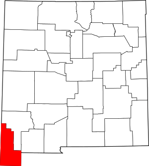 Map of New Mexico highlighting Hidalgo County | |
| Village | ||
| CDPs | ||
| Other unincorporated communities | ||
| Ghost towns | ||