Amaravathi, Guntur district
Amaravathi is a town located on the banks of Krishna River, in Guntur district of the Indian state of Andhra Pradesh.[4] It is the headquarters of Amaravathi mandal,[5] and forms part of the Andhra Pradesh Capital Region with its headquarters at new Amaravati 35 km (22 mi) east, whose name is also borrowed from the name of Amaravathi.[6]
Amaravathi Dhanyakataka, Andhranagari | |
|---|---|
Village | |
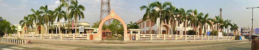
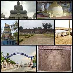 Clockwise from top left:Dhyana Buddha statue, Replica of Mahachaitya, Amareswara Ghat, Mahachaitya Relief, Amaravathi Main Road, Amareswara Temple, Mahachaitya Ruins | |
| Etymology: The place for immortals | |
 Amaravathi Location in Andhra Pradesh, India 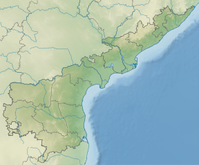 Amaravathi Amaravathi (Andhra Pradesh) | |
| Coordinates: 16.573°N 80.358°E | |
| Country | India |
| State | Andhra Pradesh |
| District | Guntur |
| Mandal | Amaravathi mandal |
| Founded | 1790 |
| Founded by | Vasireddy Venkatadri Nayudu |
| Named for | Amaravati Stupa, Amaralingeswara Temple |
| Government | |
| • Type | Panchayati raj |
| • Body | Amaravathi gram panchayat |
| Area | |
| • Total | 1,524 ha (3,766 acres) |
| Population (2011)[3] | |
| • Total | 13,400 |
| • Density | 880/km2 (2,300/sq mi) |
| Languages | |
| • Official | Telugu |
| Time zone | UTC+5:30 (IST) |
| PIN | 522020 |
| Area code(s) | +91–8645 |
| Vehicle registration | AP |
Amaravathi was founded by Raja Vasireddy Venkatadri Nayudu in 1790s as the new capital his zamindari estate. He moved there from his former capital Chintapalli in protest of alleged mistreatment by the British East India Company. Amaravathi is named after the ancient Amaravati Stupa, which was unearthed in the process of the town's construction.[7][8] It is adjacent to the ancient Satavahana capital Dhanyakataka (now called Dharanikota).[9]
Amaralingeswara temple in the village is one of the Pancharama Kshetras for the Hindus. The place was also a historic Buddhist site, depicted by the presence of Amaravati Stupa built during the 2nd century BCE and the 3rd century CE.[10][11] The Dhyana Buddha statue, a large 21st-century Buddha statue in Dhyana posture. It is one of the sites selected for Heritage City Development and Augmentation Yojana (HRIDAY) scheme of Government of India, to preserve rich cultural heritage of India.[12][13]
Etymology
The word Amaravathi translates as the place for immortals.[14] It was also known as Dhanyakataka and Andhranagari.[4]
History
The recorded history of Amaravathi and nearby Dharanikota dates to the 5th century BCE. It is a town said " a continuous history of at least 2,300 years."[15] It was the capital of Satavahanas who ruled from the 3rd century BCE to the 3rd century CE. After the decline of Satavahanas, Andhra Ikshvakus and later Pallava kings ruled Krishna river valley. Subsequently, Eastern Chalukyas and Telugu Cholas held sway over the region. Kota Kings were in control of Amaravathi during the medieval times. Kota kings were subdued by Kakatiyas in the 11th century CE and Amaravathi became part of the unified Telugu empire. The Skanda Purana gives a picture of the place and the Siva temple located here.[16]
Amaravathi was part of Delhi Sultanate, Musunuri Nayaks, Bahmani Sultanate, Vijayanagara Empire, Sultanate of Golconda and Mughal Empire successively before the founding of the Nizam of Hyderabad in 1724. It was ceded to France in 1750 but was captured by England in 1759. Guntur returned to the Nizamate in 1768 but was ceded to England again in 1788. It was briefly occupied by Hyder Ali. It was part of Madras Presidency during the British colonial period.
The Great Stūpa or mahācaitya
The most important historic monument in Amaravathi village is the Mahachaitya. It is protected by the Archaeological Survey of India which maintains a site museum beside the ruins
Geography
Amaravathi is situated at 16.579444°N 80.311111°E. It is spread over an area of 1,524 ha (3,770 acres).[2]
Demographics
As of 2011 Census of India, the town had a population of 13,400 with 3,316 households. The total population constitute, 6,432 males and 6,958 females —a sex ratio of 1,082 females per 1,000 males. 1,321 children are in the age group of 0–6 years, of which 647 are boys and 674 are girls —a ratio of 1,042 per 1,000. The average literacy rate stands at 71.34% with 8,617 literates, higher than the state average of 67.41%.[3][17]
Government and politics
Amaravathi gram panchayat is the local self-government of the village.[1] It is divided into wards and each ward is represented by a ward member.[18] The village as a part of Amaravathi mandal, represents Pedakurapadu assembly constituency.[19] The present MLA representing the constituency is Kommalapati Sridhar of Telugu Desam Party.[20]
Culture
The town is a centre of pilgrimage to both Hindus and Buddhists. The inscriptions on the walls of the Amareswara temple depicts the reign of Vasireddy Venkatadri Nayudu who ruled before the advent of the British rule. He was well known for his benevolence, munificence and for the construction of a large number of temples and education centres in the Krishna river delta.[21] It also hosts 125 ft tallest Buddhist statue in India.[22] The ancient structures and replicas can be found at Kalachakra museum, renamed as Amaravathi Heritage Centre and Museum.[23] The ruined Buddhist stupa and other remains are one of the centrally protected monumemts of national importance.[24] The main Hindu festivals celebrated are Mahasivaratri and the Navaratri. The 30th Kalachakra festival, a popular Buddhist ritual was held at Amaravathi in the first week of January 2006. It is the home for the oldest tourist places for Buddhists.[25]
Transport
The only means of connectivity for the village is by road. The Vijayawada–Amaravathi Road connects the village with cities of Vijayawada, Tenali, Guntur, Andhra Pradesh capital city areas of Undavalli, Penumaka, Rayapudi.[26] While, the Guntur–Amaravathi Road connects it with the district headquarters, Guntur.[27] It also has road connectivity from Sattenapalle, Mangalagiri and Krosuru. APSRTC operates buses from major bus stations like, NTR bus station of Guntur, Pandit Nehru bus station of Vijayawada and also to the Tenali bus stand of Tenali.[27][28][29] The village has no rail connectivity.
A waterway categorised as class–III is planned from Pulichintala to Prakasam Barrage, which connects the nearby villages of Harishchandrapuram and Vykuntapuram.[30]
Education
As per the school information report for the academic year 2018–19, the village has a total of 12 schools. These schools include 4 MPP, one KGBV and 12 private schools.[31]
See also
References
- "Gram Panchayat Identification Codes" (PDF). Saakshar Bharat Mission. National Informatics Centre. p. 95. Archived from the original (PDF) on 18 August 2017. Retrieved 7 May 2019.
- "District Census Hand Book : Guntur (Part B)" (PDF). Census of India. Directorate of Census Operations, Andhra Pradesh. 2011. pp. 14, 252. Retrieved 1 June 2019.
- "Population". Census of India. Registrar General and Census Commissioner of India. Retrieved 1 June 2019.
- Miryala, Dr Ramesh Kumar (2015). Trends, Challenges & Innovations in Management - Volume III. Zenon Academic Publishing. p. 278. Retrieved 3 June 2019.
- "District Census Handbook : Guntur" (PDF). Census of India. Directorate of Census Operations, Andhra Pradesh. 2011. pp. 5, 328–329. Retrieved 3 June 2019.
- "After 18 centuries, Amaravati set to become a 'capital' again". The Times of India. 22 October 2015. Archived from the original on 25 October 2015.
- This Raja knows how to hold the fort, The Times of India, 25 September 2016.
- Ramaswami, Indian Monuments 1971, p. 115.
- V.Rishi Kumar (23 January 2018). "The capital of Satavahanas has come a full circle". The Hindu Business Line. Retrieved 8 May 2019.
- "Buddha – Amaravathi". Archived from the original on 4 October 2017.
- "Forget the Kohinoor, could we have the Amaravathi Stupa sculptures back please?". Archived from the original on 2 August 2017.
- "Heritage City Development Scheme (HRIDAY) launched : Centre to fund entire expenditure". pib.nic.in. Ministry of Housing & Urban Affairs, India. 21 January 2015. Retrieved 8 May 2019.
- "Spotlight to shift on intangible heritage". Retrieved 7 August 2017.
- Ravikumar, Aruna (13 August 2016). "A river of talent". The Hans India. Archived from the original on 2 August 2017. Retrieved 1 May 2017.
- "Ancient sculptures found in Amaravati". Retrieved 7 October 2017.
- Skanda Purana In: Puranic Encyclopedia, 1975, Vettam Mani, Motilal Banarsidas, New Delhi
- "Literacy of AP (Census 2011)" (PDF). Official Portal of Andhra Pradesh Government. p. 43. Archived from the original (PDF) on 14 July 2014. Retrieved 5 September 2014.
- Seetharam, Mukkavilli (1 January 1990). Citizen Participation in Rural Development. Mittal Publications. p. 34. ISBN 9788170992271.
- "Delimitation of Parliamentary and Assembly Constituencies Order, 2008" (PDF). Election Commission of India. p. 22. Retrieved 11 October 2014.
- "Member's Report". Andhra Pradesh Legislature Assembly. Retrieved 12 October 2014.
- Sri Raja Vasireddy Venkatadri Nayudu, 1973, K. Lakshminarayana, Ponnuru <http://www.openlibrary.org/details/rajavasireddyven022548mbp Archived 25 June 2007 at the Wayback Machine>
- "Tallest Dhyana Buddha to be ready in Amaravathi".
- Varma, P. Sujatha (25 July 2016). "Kalachakra Museum regains lost sheenKalachakra Museum regains lost sheen". The Hindu. Retrieved 23 September 2016.
- "Centrally Protected Monuments". Archeological Survey of India. Archived from the original on 26 June 2017. Retrieved 27 May 2017.
- "India forgot Buddha for 1,000 years: Sircar". The Times of India.
- "Four lane road to Andhra Pradesh new capital soon".
- Srinivas, Rajulapudi (25 October 2013). "25 passengers rescued from stranded APSRTC bus in Narsaraopet". The Hindu. Guntur. Retrieved 8 March 2016.
- "RTC to introduce bus services in Guntur city". Deccan Chronicle. 26 November 2014. Retrieved 4 June 2016.
- "Bus services to Amaravathi from Guntur".
- "River Route Planned for Amaravathi". The New Indian Express. 26 November 2015. Retrieved 4 June 2016.
- "School Information". Commissionerate of School Education. Government of Andhra Pradesh. Retrieved 7 May 2019.
Bibliography
- Ramaswami, N. S. (1971). Indian Monuments. Abhinav Publications. ISBN 978-0-89684-091-1.