Abo Formation
The Abo Formation is a geologic formation in New Mexico. It contains fossils characteristic of the Cisuralian epoch of the Permian period.
| Abo Formation Stratigraphic range: Permian | |
|---|---|
 Hillside exposures of Abo Formation red beds | |
| Type | Formation |
| Unit of | Manzano Group |
| Underlies | Yeso Group |
| Overlies | Bursum Formation of the Madera Group[1] |
| Thickness | 280 m (920 ft) at type section |
| Lithology | |
| Primary | Mudstone |
| Other | Sandstone |
| Location | |
| Region | New Mexico |
| Country | United States |
| Type section | |
| Named for | Abo Canyon |
| Named by | W.T. Lee (1909) |
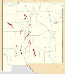 Exposures of Abo Formation in New Mexico | |
Description
The Abo Formation consists of fluvial redbed mudstones and sandstones, including river channels in its lower beds (Scholle Member) and distinctive sandstone sheets in its upper beds (Cañon de Espinoso Member.)[2] Its depositional environment was typical of the "wet red beds" of tropical Pangaea.[2] It is extensively exposed in the mountains and other uplifts bordering the Rio Grande Rift, with a thickness of 280 meters (920 feet) at the type section. It is also present in the subsurface in the Raton Basin.[3]
The base of the Abo is gradational with the Madera Group, and is usually placed at the first massive marine limestone bed below the fluvial sediments of the Abo. It is overlain by the Yeso Formation, with the base of the Yeso placed at the first massive sandstone bed showing frosted grains and other eolian features.[2] The transition zone between the Madera Group and the Abo Formation is distinctive enough in many locations that it is broken out into its own formation, the Bursum Formation.[4]
Sandstone in the exposures towards the north, at Abo Pass and in the Jemez Mountains, tends to be arkosic, with detrital feldspars dominated by potassium feldspar including microcline. Granitic rock fragments are much more common than metamorphic. Cementing is usually by calcite, but quartz cementing is often present. Carbonate grains are likely reworked caliche. The formation fines to the south. The composition and southward fining indicate a granitic source to the north.[2]
The Abo Formation was deposited in a time of rapid global warming. Carbon and oxygen isotope ratios in caliches within the formation indicate a rise in temperature from 15 to 30 degrees Centigrade during the eighteen million years in which the formation was deposited. This was accompanied by increased aridity.[5] Deposition took place on a low-gradient, broad, well-oxidized alluvial plain in which rivers flowed to the Hueco seaway in southern New Mexico. There are indications in the strata of strong seasonality typical of the megamonsoonal climate of early Permian Pangaea.[2]
The Abo transitions seamlessly to the Cutler Formation in the northern Jemez Mountains. With both names deeply entrenched in the geological literature, the convention is to use the name "Cutler Formation" north of 36 degrees north latitude and "Abo Formation" south of that latitude.[6]
Members
The Abo Formation is divided into the lower Scholle Member and the upper Cañon de Espinoso Member.[2]
The Scholle Member is dominated by mudstone (87% of the type section), with some trough-crossbedded, coarse-grained, conglomeratic sandstones (11% of the type section) interpreted as channel deposits. The remaining 2% is calcrete ledges. The member is 140 meters (460 feet) thick at the type section and is a slope-forming member. It reflect relatively rapid tectonic subsidence.[2]
The Cañon de Espinoso Member is [2] is 170 meters (560 feet) thick at the type section, of which 70% is mudstone, 21% is thin ledges of laminated climbing-rippled sandstone, and 9% is siltstone beds. The sandstones form distinctive sheet-like bodies. Thiks member was deposited as tectonic subsidence slowed, with an episodically stable base level.[2]
Fossils
The formation is notable for its trace fossils, which include rhizoliths, arthropod feeding and locomotion traces, and tetrapopd trackways.[2] A tracksite has been identified at Abo Pass which is dominated by Amphisauropsis tracks, but also shows tracks of Dromopus, Dimetropus, Batrachichnus, Hyloidichnus, Gilmoreichnus, and Varanopus.[7] Tracks are also found in the Lucero uplift in the Cañon de Espinoso Member that include Amphisauropus, Ichniotherium, Hyloidichnus, and Dromopus.[8]
The formation has also has produced plant, bivalve, conchostracan and vertebrate fossils[2] in locations such as the Spanish Queen mine near Jemez Springs,[9] which date it to the Wolfcampian (lower Permian period). Plant fossils found in the Abo Formation are mostly conifers and show two distinct paleofloras. The first, associated with red siltstone, are of low diversity and are dominated either by conifers or the peltasterm Supaia. The second paleoflora is characteristic of green shale and siltstone and is more diverse, with a variety of wetland plants, though still dominated by conifers.[2]
One green shale site in the Caballo Mountains, interpreted as an estuarine facies of the Abo Formation, contains gastropods and diverse bivalves, including euryhaline pectins and myalinids. The Scholle Member yields most of the vertebrate fossils of the Abo Fromation, typically a pelycosaur-dominated assemblage that includes lungfishes, palaeoniscoids, temnospondyl and lepospondyl amphibians, and diadectomorphs.[2]
Economic geology
The Abo Formation was mined for copper at the Spanish Queen Mine in the Jemez Springs area. The ore was discovered in 1575, but production had ceased by 1940.[10] Copper was also mined in the Scholle district, particularly from the Abo and Copper Girl mines, beginning likely in the Spanish era, ca. 1629. Modern prospectors rediscovered the deposits in 1902 and mining from 1915 to 1961 produced about a quarter million dollars of copper and other metals. Remaining copper deposits in the Abo are uneconomical to mine at 2015 prices. Copper deposits in the Abo are characterized as stratabound sedimentary-copper deposit, largely taking the form of copper oxides, chalcopyrite, and chalcocite. They were likely produced when oxidizing waters enriched in chloride and carbonate from Paleozoic beds leached copper from Proterozoic source rock, then precipitated the copper in more reduced aquifers containing hydrogen sulfide.[11]
Carbon dioxide was produced from subsurface Abo Formation beds in the Des Moines, New Mexico field from 1952 to 1966. Isotope studies suggest the carbon dioxide originated in the earth's mantle and the Abo Formation is merely a reservoir rock.[3]
History of investigation
The formation was first designated as the Abo sandstone of the Manzano Group by W.T. Lee in 1909, who named it for Abo Canyon in the southern Manzano Mountains.[12] In 1943, Needham and Bates defined a type section that excluded the basal marine limestone beds, and, finding that the unit was more shale than sandstone, redesignated it the Abo Formation.[13]
In 1946, Wiltpolt et al. removed the upper eolian sandstone beds from the Abo Formation, reassigning them to the Meseta Blanca sandstone member of the Yeso Formation.[14]
In 2005, Lucas et al. divided the Abo into two members, the lower Scholle Member and the upper Cañon de Espinoso Member.[15]
Footnotes
- Myers 1972
- Lucas et al. 2013
- Broadhead 2019
- Kues and Giles 2004, pp.98-100
- Mack and Cole, 1991
- Wood and Northrop 1946
- Lucas et al. 2001
- Voigt and Lucas 2016
- Hunt and Lucas 1996
- Western Mining History database: "Spanish Queen"
- McLemore 2016
- Lee 1909
- Needham and Bates, 1943
- Wiltpolt et al. 1946
- Lucas et al. 2005
References
- Broadhead, Ronald F. (2019). "Carbon Dioxide in the Subsurface of Northeastern New Mexico" (PDF). New Mexico Geological Society Field Conference Series. 70: 101–108. Retrieved 19 May 2020.
- Hunt, Adrian P.; Lucas, Spencer G. (1996). "Late Paleozoic fossil vertebrates from the Spanish Queen mine locality and vicinity, Sandoval County, New Mexico". New Mexico Geological Society Fall Field Guidebooks. 47: 22.
- Kues, B.S.; Giles, K.A. (2004). "The late Paleozoic Ancestral Rocky Mountain system in New Mexico". In Mack, G.H.; Giles, K.A. (eds.). The geology of New Mexico. A geologic history: New Mexico Geological Society Special Volume 11. pp. 5–136. ISBN 9781585460106.
- Lucas, S.G., Krainer, K. and Colpitts, R.M., Jr., 2005, Abo-Yeso (Lower Permian) stratigraphy in central New Mexico: New Mexico Museum of Natural History and Science, Bulletin 31, p. 101-117.
- Lucas, Spencer G.; Krainer, Karl; Chaney, Dan S.; DiMichele, William A.; Voigt, Sebastian; Berman, David S.; Henrici, Amy C. (2013). "The Lower Permian Abo Formation in Central New Mexico". New Mexico Museum of Natural History and Science Bulletin. 59: 161–180. hdl:10088/20977.
- Lucas, Spencer G.; Lerner, Allan J.; Haubold, Hartmut (2001). "First record of Amphisauropus and Varanopus in the Lower Permian Abo Formation, central New Mexico". Hallesches Jahrb. Geowiss B. 29: 69–78. CiteSeerX 10.1.1.503.8731.
- Greg H. Mack; David R. Cole (1991). "Paleoclimatic Controls on Stable Oxygen and Carbon Isotopes in Caliche of the Abo Formation (Permian), South-Central New Mexico, U.S.A.". SEPM Journal of Sedimentary Research. 61. doi:10.1306/D426773A-2B26-11D7-8648000102C1865D.
- McLemore, Virginia T. (2016). "Geology and mineral deposits of the sedimentary-copper deposits in the Scholle Mining District, Socorro, Torrance and Valencia counties, New Mexico" (PDF). New Mexico Geological Society Field Conference Series. 67: 249–254. Retrieved 10 June 2020.
- Donald A. Myers (1972), "The upper Paleozoic Madera Group in the Manzano Mountains, New Mexico", U.S. Geological Survey Bulletin, 1372, doi:10.3133/B1372F, Wikidata Q61461236
- C. E. Needham; R. L. Bates (1 November 1943), "Permian type sections in central New Mexico", Geological Society of America Bulletin, 54 (11), doi:10.1130/GSAB-54-1653, Wikidata Q61031648
- Voigt, Sebastian; Lucas, Spencer G. (2016). "Permian tetrapod footprints from the Lucero Uplift, central New Mexico" (PDF). New Mexico Geological Society Field Conference Series. 67: 387–395. Retrieved 12 June 2020.
- Willis Thomas Lee; George H. Girty (1909), "The Manzano group of the Rio Grande valley, New Mexico" (PDF), U.S. Geological Survey Bulletin, 389, doi:10.3133/B389, Wikidata Q61463147
- Wilpolt, R.H., MacAlpin, A.J., Bates, R.L. and Vorbe, G., 1946, Geologic map and stratigraphic sections of Paleozoic rocks of Joyita Hills, Los Piños Mountains, and northern Chupadera Mesa, Valencia, Torrance, and Socorro Counties, New Mexico: U.S. Geological Survey Oil and Gas Investigations, Preliminary Map 61.
- Gordon H. Wood; Stuart Alvord Northrop (1946), "Geology of the Nacimiento Mountains, San Pedro Mountain, and adjacent plateaus in parts of Sandoval and Rio Arriba Counties, New Mexico", Oil and Gas Investigations Map, 57, doi:10.3133/OM57, Wikidata Q62639452