A Map of Middle-earth
"A Map of Middle-earth" is the name of two colour posters by different artists, published in the late 1960s and early 1970s by the American and British publishers of J. R. R. Tolkien's book The Lord of the Rings. Both posters were based on cartography by J. R. R. Tolkien and Christopher Tolkien to depict the fictional region of Middle-earth. None of these maps cover the whole continent of Middle-earth; instead they only portray the north-western part of the continent, where the story of The Lord of the Rings takes place.

The earlier poster, signed "BRem" (Barbara Remington), was published in the 1960s by Ballantine Books[1] and features border images adapted from Remington's cover designs for the 1965 Ballantine paperback edition of The Lord of the Rings.
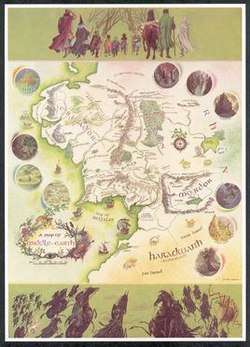
The second version, by Pauline Baynes, was published in 1970 by George Allen & Unwin[2] in the UK and Ballantine Books in the USA. It features ten small inset illustrations of important locations from the story. The poster is framed at the top by a row of nine figures representing the members of the "Fellowship of the Ring" setting out on their quest. At the bottom is an array of antagonists from the novel, including the nine Black Riders, Gollum, Shelob, and various Orcs.
References
- Hammond, Wayne G.; Scull, Christina (14 February 2011). "Addenda and Corrigenda to The J.R.R. Tolkien Companion and Guide (2006), Vol. 1: Chronology · Arranged by Date". Wayne & Christina. Retrieved 2011-09-21.
- Hammond, Wayne G.; Anderson, Douglas A. (1993). J.R.R. Tolkien: A Descriptive Bibliography. Winchester: St. Paul’s Bibliographies. p. 376. ISBN 1-873040-11-3.
External links
- Map of Middle-earth, showing the movements of characters from both The Lord of the Rings and The Hobbit film series by Peter Jackson
- In the Beginning was the Word: How Medieval Text Became Fantasy Maps tracing the roots of Tolkien's mapping influences to medieval prefatory textual practices.
| Main works | |||||||||||||
|---|---|---|---|---|---|---|---|---|---|---|---|---|---|
| Other works | |||||||||||||
| Posthumous publications | |||||||||||||
| Fictional universe |
| ||||||||||||
| Adaptations and legacy | |||||||||||||
| Maps and reference books | |||||||||||||
| Literary criticism |
| ||||||||||||
| |||||||||||||