2017 Oregon wildfires
The 2017 Oregon wildfires were a series of wildfires that burned over the course of 2017.
| 2017 Oregon wildfires | |
|---|---|
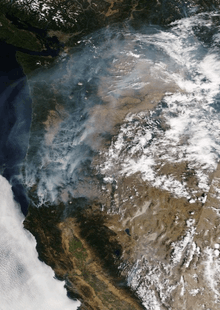 US West Coast August 29, 2017 (satellite image). Large fires visible in the Washington and Oregon Cascades, with smoke from Oregon flowing north. | |
| Statistics | |
| Date(s) | June–October, 2017 |
| Season | |
← 2016
2018 → | |
The 2017 fire season in the state of Oregon was a particularly notable one. There has been a trend for the last three decades that shows an increase in the overall number of wildfires as well as the fire season length in the state of Oregon.[1] In 2017 Oregon experienced a total of 1,069 reported wildfires: with 779 human ignited and 290 ignited by lightning strikes.[2] These fires burned a total area of 451,863 acres.[3] The catalyst for these fires was the abnormal weather patterns that persisted throughout 2017.
Fire season typically begins in Oregon in May.[4] Fires burning through September 2017 led to the month being dubbed "Smoketember" in Oregon,[5] with air quality in western Oregon listed from "Unhealthy" to "Hazardous" in early weeks. NASA published images of the Oregon, shown the typically green state to be highly obscured by smoke, as seen from space.[6] 2017 was unusual for the large number of fires occurring west of the Cascade Range in dense Douglas-fir forest in contrast to the frequent-fire pine ecosystems to the east.
Large fires include the Chetco Bar Fire in Curry County, Oregon, and the Eagle Creek Fire in the Columbia River Gorge National Scenic Area, which was started by illegal fireworks use.[7] Fires in the Columbia River Gorge shut down Interstate 84, the state's major east–west freeway, for several days in early September.[8]
2017 climate in Oregon
The 2016/2017 winter in Oregon was the second wettest winter in the past 75 years. Between the dates of October 1, 2016, and April 26, 2017, Portland International Airport received 45.5 inches (116 centimeters) of rain. The month of February 2017 was the wettest February on record in Oregon with 10.36 inches (26 centimeters) of rain.[9] During the month of August, the weather station at Portland International Airport recorded a monthly average temperature of 73.6 degrees Fahrenheit (23.1 C) with the daily average temperature hitting 87 degrees Fahrenheit (30.5 C). The average temperature during the month of August 2017 was five degrees higher than the average August temperature recorded since 1941. It stands to be the second hottest August on record.[10]
The extreme winter and summer weather that occurred in 2017 was met by some dangerous weather patterns in the late summer months. Early August through September in Southern Oregon saw several waves of thunderstorms. These storm systems brought rainfall which helped slow the growth of existing wildfires. However, the storms also brought lighting which resulted in the ignition of new fires. These storms travel on fast moving paths. After one these storms moves over an area, it quickly returns to a hot dry state. This allows for the newly ignited fires to spread quickly and develop into full wildfires.[11]
Significance of the 2017 fire season
The future climate in the Pacific Northwest is expected to be significantly different. Projections show that annual temperatures will rise faster than the global norm. Although temperatures will be higher, winters are expected to experience more rainfall.[12] These seasonal extremes are exactly the type of trends that were experienced in 2017. Climatic patterns such as these provide ample rainfall throughout the spring which allows for high rates of plant growth. The high temperatures in the summer then quickly dries up the new growth. This leads to large spread availability of dry grasses and small diameter fuels. The combination of these climate driven phenomenon are what led to the extreme fire season in Oregon in 2017.
Cheatgrass
Another problem plaguing Oregon in 2017 was invasive cheatgrass. This grass has its origins in Eurasia and has become a huge problem in Oregon. In burned areas this grass quickly replaces native vegetation such as sagebrush. Cheatgrass is especially dangerous in regards to wildfires because it is highly dependent on water and typically dries out a month before native Oregon grasses. The high rainfall in 2017 allowed cheatgrass to spread abundantly throughout eastern Oregon. In areas that have cheatgrass, fire seasons have essentially been lengthened by a month due to the sooner availability of fuel.[13] Due to its ability to both cause fires and repopulate burned areas cheatgrass is in a positive feedback loop of continual dispersal.[14]
Human-ignited fires
Oregon’s population has been in a steady state of growth for the last three decades.[15] With higher populations comes higher risk of human ignited forest fires. 2017 saw the devastating effects of human influenced fires. The Eagle Creek Fire burned 48,831 acres of land. This fire was ignited by a smoke bomb carelessly thrown by a 15-year-old boy.[16] Something as simple as the exhaust pipe of a car or a cigarette out of a car window can start a devastating fire.
Wildfires
Table contains 2017 wildfires in Oregon that burned over 1,000 acres
| Name | National Forest | Acres Burned | Start Date | Containment Date | Notes | Ref |
|---|---|---|---|---|---|---|
| Milli Fire | Deschutes National Forest | 24,079 | August 11, 2017 | September 24, 2017 | Cause:Lighting | [17] |
| Cinder Butte Fire | Bureau of Land Management | 52,462 | August 2, 2017 | August 10, 2017 | Cause:Unknown/Man caused | [18] |
| Desolation Fire | Ochoco National Forest | 4,512 | September 9, 2017 | Unknown | Cause:Lightning holdover fire | [19] |
| High Cascades Complex | Rogue River–Siskiyou National Forest Fremont–Winema National Forest Umpqua National Forest Crater Lake National Park | 27,476 | August 13, 2017 | approx. October 15, 2017 | Cause:Lighting/Natural | [20] |
| Horse Creek Complex | Willamette National Forest | 42,489 | August 10, 2017 | approx. September 27, 2017 | Cause:Lighting | [21] |
| Staley Fire | Willamette National Forest | 2,300 | August 9, 2017 | approx. December 1, 2017 | Cause:Lighting | [22] |
| Jones Fire | Willamette National Forest | 10,114 | August 10, 2017 | approx. October 14, 2017 | Cause:Lightning/Natural | [23] |
| Whitewater Fire | Willamette National Forest | 14,451 | July 23, 2017 | October 31, 2017 | Cause:Lightning/Natural | [24] |
| Umpqua North Complex | Umpqua National Forest | 43,158 | August 11, 2017 | approx. October 30, 2017 | Cause:Unknown | [25] |
| Falcon Complex | Umpqua National Forest | 2,935 | August 8, 2017 | September 15, 2017 | Cause:Lightning/Natural | [26] |
| Chetco Bar Fire | Rogue River–Siskiyou National Forest | 191,125 | July 12, 2017 | November 2, 2017 | Cause:Lightning, 8th largest fire in Oregon’s recorded history | [27][28] |
| Miller Complex | Rogue River–Siskiyou National Forest | 39,715 | August 14, 2017 | November 9, 2017 | Cause:Lightning | [29] |
| Eagle Creek Fire | Columbia River Gorge National Scenic Area | 48,831 | September 2, 2017 | November 30, 2017 | Cause:Human | [30] |
Others fires include:[31]
- Ana Fire
- Blanket Creek Fire
- Indian Creek Fire
- Upper Mine Fire
- Horse Prairie Fire – Douglas County, Oregon
- Jade Creek Fire – Fremont–Winema National Forest
- Potato Hill Fire – Willamette National Forest
- Nash Fire – Willamette National Forest and Deschutes National Forest
- North Pelican Fire – Fremont-Winema National Forest
Fires on ODF land
The majority of the burned area within Oregon Department of Forestry (ODF) held land occurred within the SOA fire region which includes the districts: Southwest, Coos, Douglas, South Cascade, and Western Lane. The SOA fire region experienced 38,384.33 acres of burned land. The EOA fire region had the second highest amount of burned area and includes the fire districts of: Central Oregon, Northeast Oregon, Klamath- Lake, and Walker Range. This fire region experienced a total of 4,992.6 acres of burned land. The NOA saw the least amount of area burned but still had 151 individual fires ignited within the region. The NOA fire region includes the fire districts of: Tillamook, Astoria, Forest Grove, West Oregon, and North Cascade. The fires in this region accounted for a total of 2168.88 acres of burned land. In 2017 the Oregon Department of Forestry had 45,681.5 acres of land burned in their forests.[2]
References
- Ana, Barros; Alan, Ager; Michelle, Day; Haiganoush, Preisler; Thomas, Spies; Eric, White; Robert, Pabst; Keith, Olsen; Emily, Platt; John, Bailey; John, Bolte (February 24, 2017). "Spatiotemporal dynamics of simulated wildfire, forest management, and forest succession in central Oregon, USA". Ecology and Society. 22 (1). doi:10.5751/ES-08917-220124. ISSN 1708-3087.
- "Oregon Department of Forestry - Daily Fire Statistics". www.odf.state.or.us.
- "OREGON Incidents". InciWeb, Incident Information System. Archived from the original on December 9, 2017. Retrieved December 11, 2017.
- Kristian Foden-Vencil (April 14, 2017), It's Raining, But Wildfire Season Is Starting In Washington, Oregon Public Broadcasting
- "Smoketember in Oregon: Smoke shrouding Beaver State visible from space". KVAL. August 31, 2017. Retrieved September 20, 2017.
- "Smoke Obscures Much of the Pacific Northwest". NASA. July 31, 2017. Retrieved September 20, 2017.
- Wilson, Anna Griffin | Conrad. "Eagle Creek Fire Witness: Young Hikers Giggled As Firecracker Descended Into Gorge Canyon". www.opb.org. Retrieved September 6, 2017.
- Ryan, Jim (September 13, 2017). "Columbia gorge fire now 13% contained; I-84 in Oregon remains closed". The Oregonian. Retrieved September 14, 2017.
- Le, Phuong; Flaccus, Gillian. "Portland Close To Breaking Rain Record, While Seattle Crushes Its Record". www.opb.org. OPB. Archived from the original on December 10, 2017. Retrieved December 11, 2017.
- Ryan, Jim. "August is hottest on record at PDX; more on way for Labor Day". OregonLive.com. Oregonian.
- Manning, Jeff. "Changing weather aids firefighters, but for how long?". OregonLive.com. Oregonian.
- Mote, Philip W.; Salathé, Eric P. (May 18, 2010). "Future climate in the Pacific Northwest" (PDF). Climatic Change. 102 (1–2): 29–50. doi:10.1007/s10584-010-9848-z.
- Hamway, Stephen. "Cheatgrass returns to Central Oregon". bendbulletin.com. The Bulletin.
- Coates, Peter. "Excess wildfire, cheatgrass affecting sage-grouse; targeted actions needed | News and Research Communications | Oregon State University". oregonstate.edu.
- "POPULATION FORECASTS BY AGE AND SEX" (PDF). Oregon.gov.
- Brettman, Allan. "Charges filed against 15-year-old boy in Eagle Creek fire". OregonLive.com. Oregonian.
- "The Milli Fire is 100% contained". Inciweb.nwcg.com. Retrieved December 21, 2017.
- "Cinder Butte Fire : INCIDENT UPDATED 8/8/2017". Inciweb.nwcg.com. Retrieved December 21, 2017.
- "EVACUATION LEVEL LOWERED FOR THE DESOLATION FIRE". Inciweb.nwcg.com. Retrieved December 21, 2017.
- "High Cascade Complex : INCIDENT UPDATED 10/4/2017". Inciweb.nwcg.com. Retrieved December 21, 2017.
- "Horse Creek Complex : INCIDENT UPDATED 6 DAYS AGO". Inciweb.nwcg.com. Retrieved December 21, 2017.
- "Staley Fire : INCIDENT UPDATED 10/16/2017". Inciweb.nwcg.com. Retrieved December 21, 2017.
- "Jones Fire : INCIDENT UPDATED 10/16/2017". Inciweb.nwcg.com. Retrieved December 21, 2017.
- "Whitewater Fire : INCIDENT UPDATED 12/8/2017". Inciweb.nwcg.com. Retrieved December 21, 2017.
- "Umpqua North Complex : INCIDENT UPDATED 10/16/2017". Inciweb.nwcg.com. Retrieved December 21, 2017.
- "Falcon Complex : INCIDENT UPDATED 10/16/2017". Inciweb.nwcg.com. Retrieved December 21, 2017.
- "Chetco Bar Fire : INCIDENT UPDATED 11/4/2017". Inciweb.nwcg.com. Retrieved December 21, 2017.
- "The worst wildfires in Oregon history: How does Eagle Creek compare?". Oregonlive.com. Retrieved December 21, 2017.
- "Miller Complex : INCIDENT UPDATED 11/9/2017". Inciweb.nwcg.com. Retrieved December 21, 2017.
- "Eagle Creek Fire : INCIDENT UPDATED 22 HRS. AGO". Inciweb.nwcg.com. Retrieved December 21, 2017.
- Terry, Lynne (July 31, 2017). "Wildfires scattered around Oregon". Oregon Live. Retrieved September 6, 2017.
External links
| Wikimedia Commons has media related to 2017 wildfires in Oregon. |
Oregon wildfires | |
|---|---|
| Pre-2000 | |
| 2000–2015 | |
| 2017 |
|
| 2018 | |
| |