2017–18 North American winter
The 2017–18 North American winter refers to winter in North America as it occurred across the continent from late 2017 through early 2018. Similar to the previous winter, a La Niña was expected to influence the winter weather across North America. Winter weather patterns were very active, erratic, and protracted, especially near the end of the season. Significant events included rare snowfall in the South, a strong cold wave that affected the United States during the early weeks of January, and a series of strong nor'easters that affected the Northeastern U.S during the month of March. In addition, flooding also took place during the month of February in the Central United States. Finally the winter came to a conclusion with a powerful storm system that caused a tornado outbreak and flooding in mid-April. The most intense event, however, was an extremely powerful cyclonic blizzard that impacted the northeastern United States in the first week of 2018.
| 2017–18 North American winter | |
|---|---|
 A temperature map of the variable conditions in Central North America on February 21, 2018 | |
| Seasonal boundaries | |
| Astronomical winter | December 21 – March 20 |
| Meteorological winter | December 1 – February 28 |
| Most notable event | |
| Name | January 2018 North American blizzard |
| Duration | January 2–6, 2018 |
| Maximum snow accumulation | |
| Highest snowfall total | 39.3 in (100 cm) (Cobleskill, New York) |
| Event | March 1–3, 2018 |
While there is no well-agreed-upon date used to indicate the start of winter in the Northern Hemisphere, there are two definitions of winter which may be used. Based on the astronomical definition, winter began at the winter solstice, which in 2017 occurred on December 21, and ends at the March equinox, which in 2018 occurred on March 20.[1] Based on the meteorological definition, the first day of winter is December 1 and the last day February 28.[2] Each definition involves a period of approximately three months, with some variability with both definitions containing two months and a week. Winter is often defined by meteorologists to be the three calendar months with the lowest average temperatures. Since both definitions span the calendar year, it is possible to have a winter storm in two different years.
Seasonal forecasts
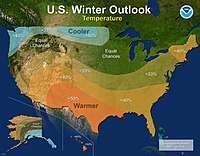

On October 19, 2017, the National Oceanic and Atmospheric Administration's Climate Prediction Center released its U.S. Winter Outlook. The outlook noted a 55–65% chance that a La Niña would develop. According to CPC Deputy Director Mike Halpert, any such La Niña was expected to be "weak and potentially short-lived", but it could still affect the season. He also noted that La Niña years normally result in colder-than-average, wetter winters in the northern tier of the United States and the inverse conditions across the south. In terms of precipitation, wetter-than-average conditions were favored across the majority of the northern United States, including a region spanning from the northern Rocky Mountains to the eastern Great Lakes in addition to the Ohio Valley, Hawaii, and western and northern Alaska. Drier conditions were anticipated across the entire southern United States. Above-average temperatures were favored across the southern two-thirds of the contiguous United States and along the east coast, as well as in Hawaii and the northern and western parts of Alaska. The outlook favored below-average temperatures in the northern tier, from Minnesota to the Pacific Northwest region as well as southeastern Alaska. The remainder of the country was assigned equal chances of either above or below-normal temperatures or precipitation. The drought outlook noted that drought was likely to remain in parts of the northern Plains, with recovery likely to the west. The development of limited regions of drought was possible in regions that did not receive rainfall associated with tropical systems during the 2017 Atlantic hurricane season.[3]
Seasonal summary
The month of November began with the highest snow extent in at least one and a half decades, with snow covering over a quarter of the contiguous United States,[4] 22% more than the same date in 2011, the next-most-recent year with comparable snow coverage at that date. However, this trend did not last through all of the month, with the last week having the least snowfall of that time of year for the same time period.[5]
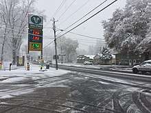
Starting in December and ending in January, a cold wave sent frigid temperatures to many states in the United States over the holidays. This cold wave fueled a winter storm which gave more than a foot of snow to many states along the East Coast.
In mid-January, most of the United States recorded snow because of two winter storms. The first one affected the Northwest and Midwest. The second one affected the Midwest, Southeast, and Northeast.
The two days subsequent from Presidents' Day in the Eastern United States featured a record warm spell, breaking record highs in places from the Gulf Coast to New England.
Weather forecasters had forecasted a slow transition to spring, unlike the year before. After the record-warmth came in February, a block that formed in Greenland that dominated between late-February and late-March claimed responsibility for four nor'easters and making it the snowiest month of March on record in certain places of the Northeastern United States. After February 21, it would not be until the final days of March that the Mid-Atlantic would see days reaching 70F.
When the calendar flipped to April, the cold and snow continued in the Midwestern and Northeastern United States, setting more records.
Events
Mid-November cold wave
After an exceptionally warm September and October for many places in the Midwestern and Northeastern United States, a strong Arctic airmass entered the Midwest on November 9, resulting in some of the coldest temperatures ever recorded this early in the season. Lake-effect snow fell in places like the Upper Peninsula of Michigan, where the Mackinac Bridge had to be closed due to low visibility.[6] Chicago on November 10 also reported Lake-effect snow.[7] The timeframe of November 10–11 broke record lows from northern Minnesota to the New York City tri-state area. On November 10, record lows were recorded in the Midwest. Among these November 10 records were five locations in the Upper Midwest that plunged below zero. In addition to the International Falls, Minnesota, the coldest, and even earliest, record lows mentioned above were set in Hibbing, Minnesota −12 °F (−24 °C), Duluth, Minnesota and Pellston, Michigan −5 °F (−21 °C), and Merrill, Wisconsin −1 °F (−18 °C).[8] The Arctic intrusion on November 10 came as a shock to people that had yet to seen temperatures cold enough for frost, especially in New England. Before then, not only it was one of the warmest Fall seasons to that date, places like Philadelphia and Washington D.C. had yet to see a day/night that was below 40 °F (4 °C) since the previous Spring earlier that year. The low temperature in Philadelphia early in the morning of November 11 was 23 °F (−5 °C). This came two degrees within reaching the record set for that day in 1961. Washington D.C. tied their record of 26 °F (−3 °C) that same morning set back in 1973. Many cities in the Great Lakes and Northeast set record lows that morning, which record lows were recorded as far south as Charlotte, North Carolina. Forecasters even called for an earlier start to winter ahead of this cold wave.[9][10][11]
Early December winter storm
A strong winter storm affected areas from northeastern Mexico to the Northeastern United States in early December. The origins of the storm were complex, with the initial disturbance forming over the extreme southern United States as a stationary front left behind from a departing extratropical cyclone on December 7.[12] At the same time, a cold air mass was establishing itself into the Deep South. A large plume of moisture encompassed the entire Gulf Coast, and snow broke out early on December 8 in places that rarely even see snow, including Mexico, southeastern Texas and Louisiana – even in the Florida Panhandle.[13][14] The storm dropped up to 25 inches (64 cm) of snow in some parts of the Southeast as it slowly moved eastwards, breaking several snowfall records; meanwhile, a gulf low formed in the Gulf of Mexico the same day – this would ultimately become the dominant low of the system.[15][16] Transitioning into an extratropical cyclone off the east coast of the United States, the system began moving parallel to the shoreline, with a large swath of snowfall accompanying it. The low slowly deepened throughout the day of December 9, bringing the first snow of the season to many parts of the Northeast and New England.[16]
Up to 400,000 people were left without power across the affected regions, several schools and roads shut down, and 3 were have confirmed to have been killed by the storm as of December 9.[14]
Post-Christmas to mid-January cold wave
In late December, a strong Arctic air mass, due to the weakening of the Northern Polar vortex, came and established from Canada into the Midwestern and Northeastern United States with the core of the cold centered in the Upper Midwest, Interior Northeast, and Eastern Canada. Temperatures were 10 to 20 °F (6 to 11 °C) below average for that time of year. International Falls, Minnesota recorded a record low temperature on December 27 of −32 °F (−36 °C).[17] In Indianapolis, Indiana, the temperature reached a new low of −12 °F (−24 °C).[18] In 2017, Watertown, New York and Buffalo, New York each had it coldest final week on record for the year.[19]
On January 2, a daily record low in Sioux City, Iowa was set at −28 °F (−33 °C). Other daily record low temperatures included Cedar Rapids, Iowa −23 °F (−31 °C), Pierre, South Dakota −21 °F (−29 °C), South Bend, Indiana −15 °F (−26 °C),Quincy, Illinois −12 °F (−24 °C) and Lynchburg, Virginia 3 °F (−16 °C).[20]
In the first few days of 2018, the cold front was stretched as far south into the Caribbean.[21][22]
Early January blizzard
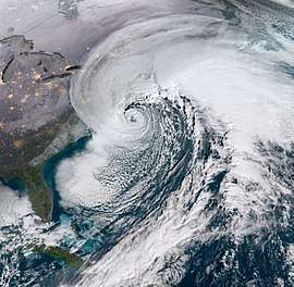
A severe blizzard caused disruption along the Eastern United States in the first few days of the new year. It provided snow in municipalities that do not often receive and therefore are not accustomed to handling winter precipitation, such as Georgia and Florida, and accumulated over 2 feet (61 cm) of snow in New England, the Mid-Atlantic states, and Eastern Canada. The storm started on January 3, 2018, moving rapidly to the northeast, after which time the system moved east, causing great snowfall. The storm was also dubbed as a "historic bomb cyclone".[23]
The blizzard produced snowfall and other forms of frozen precipitation across much of the United States Eastern Seaboard. As of the WPC's fifth winter storm summary, the highest official snowfall amount recorded is 17.0 in (43 cm) in Cape May Court House, New Jersey; however, a snowfall total of 52 centimetres (20 in) was reported in Bathurst, New Brunswick. Freezing rain totals peaked at 0.5 in (1.3 cm) in Brunswick, Georgia and near Folkston, Georgia.[24] At least twenty-two fatalities were attributed to the storm, including at least eight car accident-related deaths. At least 4,020 flights were cancelled across the United States, with a majority of cancellations caused by the extensive winter storm. Insurers estimate that claims relating to coastal flooding from the storm will be more than those from snow-related damage.[25]
Mid-January winter storms
In mid-January, two winter storms caused widespread disruption across the eastern half of the United States. The first one spread a swath of snow and ice across the northern parts of the Ohio Valley and New England, as a strong cold front pushed through the regions with a developing low.[26] Several locations received up to a quarter inch of ice while others observed over 1 foot (12 in) of snow.
The second one, although much less widespread than the first one, crossed Southern, Midwestern, and Northeastern United States and brought snow to places that rarely see it. This storm hit Texas and the Midwest on January 16, 2018. Then, the storm impacted New England and Mid-Atlantic states on January 17. Up to 2 inches (5.1 cm) fell in Shreveport, Louisiana, marking the first time more than an inch of snow fell in Shreveport since 2015. Austin, Houston, and San Antonio, Texas saw many vehicle accidents because of sleet and freezing rain on the morning of January 16. This led to an overwhelming amount of vehicular accidents, such as several accidents in the Dallas-Fort Worth metroplex near Canton. In Galveston, hundreds of pipes froze and burst, depleting the city's water reserves to drought levels and forcing Galveston County and Chambers County to implement mandatory water conservation measures until the pipes could be fixed. Florida observed snow for the third time during the winter, with snow and freezing rain observed in portions of the Florida Panhandle. Snow fell in Crestview and DeFuniak Springs while freezing rain fell in Fort Walton Beach. Pensacola saw sleet which accumulated on grass and vehicles. The Bob Sikes Bridge to Pensacola Beach was closed due to ice.[27] In North Carolina on January 17, Winston-Salem received 6 inches (15 cm) of snow, Greensboro had 6 inches (15 cm) to 8 inches (20 cm), Burlington had 8 inches (20 cm) to 9 inches (23 cm),[28] and part of Durham had 9.5 inches (24 cm), while areas to the north of Durham had 10 inches (25 cm) to 12 inches (30 cm).[29] Snow fell on portions of the East Coast and Northeast. East Machias, Maine got 11 inches (28 cm), Stockbridge, Massachusetts got 11 inches (28 cm), Rosendale, New York got 10 inches (25 cm), Loyseville, Pennsylvania got 9.5 inches (24 cm), Dover, New Hampshire got 8 inches (20 cm), Canaan, Connecticut got 7 inches (18 cm), and Wantage, New Jersey got 6.4 inches (16 cm).[30]
Late February flooding
Heavy rains led to intense flooding in the central U.S. from Texas to Michigan in the second half of February, including along the portion of the Ohio River running past Cincinnati and Louisville.[31]
March nor'easters
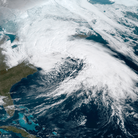
After a period of record warmth in late February, weather patterns across the continent abruptly became much more active in March. Four powerful nor'easters affected the United States and eastern Canada in that month alone, each dropping more than a foot of snow in the areas affected.
- First nor'easter - March 1–3
The first nor'easter began to take shape over the Mid-Atlantic states at the transition of February and March. As an area of low pressure moved into the interior Northeast late on March 1, snowfall fell in areas close to the Canada–United States border, while precipitation in coastal areas was rain due to slightly warmer air.[32] Overnight into the early morning hours of March 2, a new area of low pressure formed and rapidly strengthened off the coast of New Jersey, while snow began to slowly increase in coverage near Pennsylvania and southern New York.[33] Wet bulbing helped bring snow to areas closer on the coast, such as New York City. Although the most severe damage was caused by flooding as well as snow, unusually high tides and storm surges along the coast, wind and downed trees caused massive inland power outages,[34][35][36] with the number of outages as high as 1.6 million at one point.[37] As of March 2, at least 15 people are known to have been killed as a result of the storm, five from falling trees or branches.[37]
- Second nor'easter - March 6–8
As the first nor'easter occurred, a smaller, but significant blizzard struck the Sierra Nevada mountains and then tracked across the continent as a large weather front, dropping snow across the Midwestern United States and interior Canada. As it reached the Great Lakes on March 6, another low pressure area formed off the Outer Banks of North Carolina. By mid-afternoon the next day, the two systems had merged into a second nor'easter, which rapidly intensified off the New Jersey coastline and dropped up to over 3 feet (36 in) or more of wet snow across much of the Northeast, which hampered the recovery efforts from the first nor'easter. The storm caused up to 1 million people to lose power, and at least 1 person has been confirmed dead due to the storm as of March 7. Hundreds of flights were cancelled across the region, and many schools closed due to the nor'easter, although some opted to remain open. Many freeways were also closed in the regions, and several states were put under state of emergencies. In Pennsylvania, Governor Tom Wolf declared a state of emergency for several counties in the eastern part of the state.[38] A snow emergency went into effect for the city of Philadelphia on the morning of March 7.[39] Several municipalities in the Philadelphia area declared snow emergencies and many schools and government offices were closed on March 7. Many attractions in the Philadelphia area either closed early or were closed for the entire day on March 7.[40] The nor'easter had moved off by the morning of March 9, but its remnants stalled over Maritime Canada and persisted throughout the weekend.
- Third nor'easter - March 12–14
On the night of March 11, several areas of low pressure developed over the American Southeast and merged into a third nor'easter within 24 hours. On March 13, the storm produced blizzard conditions and a swath of 1–3 feet of snow in New England as it moved northeast into the Gulf of Maine. The storm brought heavy snow blizzard conditions to Rhode Island on March 13. Blizzard conditions were reported in Newport. Most of the state received at least one foot of snow, peaking at 25.1 inches (64 cm) in Foster.[41] The storm brought heavy snow and blizzard conditions to Massachusetts on March 13. Blizzard conditions were reported in several locations including Boston, Hyannis, Falmouth, Plymouth, Marshfield, and Martha's Vineyard. Over two feet of snow were reported in portions of the state, peaking at 28.3 inches (72 cm) in Methuen. Wind gusts of 47 mph (76 km/h) were reported at Logan International Airport in Boston while gusts reached 77 mph (124 km/h) on Nantucket Island, 79 mph (127 km/h) in Hyannis, and 81 mph (130 km/h) in East Falmouth.[42] A storm surge of 3 feet (0.91 m) was reported on Nantucket while a 2.8 feet (0.85 m) storm surge was recorded in Boston.[41] Over a foot of snow was reported in portions of New Hampshire,[41] with Deefield receiving almost 29 inches and Middleton reported 28 inches. No widespread power outages were reported.[43] The storm brought heavy snow and blizzard conditions to Maine on March 13. Blizzard conditions were reported in Portland. Over a foot of snow was reported in portions of the state.[41]
Of the four nor'easters, the third storm was the strongest in terms of minimum pressure, at 966 mb.
- Fourth nor'easter - March 20–22
The fourth nor'easter began to take shape on March 19, and lasted until March 23. This nor'easter tracked further south than the previous three, due to an area of high pressure over Quebec and New England.
- Late-March North Atlantic cyclone
Near the end of March, an extremely powerful extratropical cyclone formed in the North Atlantic. This storm could have become a fifth nor'easter, but it tracked far out to sea and so was not classified as such.[44]
Mid-April winter storm
In mid-April, a powerful weather system created heavy snow and blizzard conditions over much of the upper Midwest, as well as severe weather in the South. Green Bay, Wisconsin reported 24.2 inches (61 cm), its second-heaviest snowstorm of all time and largest ever for the month of April. Further east, a severe ice storm took place. Up to 1 inch (25 mm) was reported in Lowville, New York, in the foothills of the Tug Hill Plateau.[45] In Ontario, a mix of snow, freezing rain, ice pellets and rain battered Toronto and the surrounding area, causing hundreds of vehicle collisions, flight cancellations, power outages and transportation delays. Freezing rain also caused problems in Ottawa, Montreal, and parts of New Brunswick.[46]
See also
Notes
- While the graphic portrays below-average precipitation as favored for Hawaii, the outlook text and other NOAA sources indicate that above-average precipitation is favored.
References
- "Earth's Seasons: Equinoxes, Solstices, Perihelion, and Aphelion, 2000-2025" (PHP). Washington, D.C.: United States Naval Observatory. August 10, 2017. Archived from the original on August 15, 2015. Retrieved October 19, 2017.
- "Meteorological vs. Astronomical Seasons". NOAA National Centers for Environmental Information. June 21, 2013. Retrieved October 19, 2017.
- "U.S. Winter Outlook: NOAA forecasters predict cooler, wetter North and warmer, drier South: Drought likely to persist in northern Plains". National Oceanic and Atmospheric Administration. October 19, 2017. Retrieved November 11, 2017.
- Erdman, Jonathan (November 8, 2017). "Early November Snow Cover in North America the Highest in Over a Decade". The Weather Channel. Retrieved November 28, 2017.
- Erdman, Jonathan (November 28, 2017). "Lower 48 States Snow Cover Hits Record Low For the Last Week of November". The Weather Channel. Retrieved November 28, 2017.
- "Royce, J. (2017, November 9). Lake effect snow hits northern Michigan. Retrieved December 29, 2017".
- "Sun-Times Wire. (2017, November 10). Lake effect snow showers cause driving woes, sends plows to streets. Retrieved December 29, 2017".
- "Donegan, B. (2017, November 11). Arctic Cold Setting Dozens of Daily Records in the Northeast, Midwest Through Veterans Day - wunderground.com. Retrieved December 29, 2017".
- "Wood, A. R. (2017, November 09). Freeze warning - could be coldest Veterans Day on record. Retrieved December 28, 2017".
- "Wood, A. R. (2017, November 13). After record cold, can snow scares be far behind? Retrieved December 28, 2017".
- "Samenow, J. (2017, November 07). Winter is taking charge early this November, and won't be super warm like the last two. Retrieved December 28, 2017".
- "WPC Surface Analysis for 12/07/17". Weather Prediction Center. December 7, 2017. Retrieved December 8, 2017.
- "WPC Surface Analysis for 12/08/17". Weather Prediction Center. December 8, 2017. Retrieved December 9, 2017.
- Breslin, Sean. "Winter Storm Benji Targets Northeast After Leaving Nearly 400,000 Without Power In the South, 3 Dead". The Weather Channel. Retrieved December 9, 2017.
- "WPC Surface Analysis for 12/08/17". Weather Prediction Center. December 8, 2017. Retrieved December 9, 2017.
- Erdman, Jonathan. "Winter Storm Benji Bringing the Northeast Seaboard's First Snow of the Season After Dropping Record-Setting Deep South Snow". The Weather Channel. Retrieved December 9, 2017.
- Davidson, Lawrence. "Arctic air brings bone-chilling temperatures to US". CNN. Retrieved 2018-01-02.
- "Record-breaking cold sweeps US in first days of 2018". 2 January 2018. Retrieved 4 January 2018 – via Christian Science Monitor.
- "Times Square braces for one of coldest New Year's Eve parties on record". The Guardian. Associated Press. 2017-12-31. ISSN 0261-3077. Retrieved 2018-01-01.
- "Dangerously Cold Temperatures to Grip Northeast After Winter Storm Grayson as Arctic Outbreak Continues". Retrieved 4 January 2018.
- Cold front to enter region tomorrow., The Jamaica Observer, January 2, 2018
- Havana Weather for January 4-10, Havana Times, January 4, 2018
- Samenow, Jason (January 4, 2018). "Historic 'bomb cyclone' unleashes blizzard conditions from coastal Virginia to New England. Frigid air to follow". Washington Post. Retrieved January 4, 2018.
- Kong, Kwan-Yin (January 4, 2018). "Storm Summary Number 5 for Eastern U.S. Coastal Winter Storm". Storm Summary Message. College Park, Maryland: National Weather Service's Weather Prediction Center. Retrieved January 4, 2018.
- "Insurers brace for coastal flood losses from US 'bomb cyclone'". Insurance Day. 5 January 2018. Retrieved 8 January 2018.
- "Storm Summary Number 2 for Lower Mississippi, Tennessee, and Ohio Valleys to Lower Great Lakes Winter Storm". Storm Summary Message. College Park, Maryland: National Weather Service's Weather Prediction Center. January 12, 2018. Retrieved January 17, 2018.
- "Winter Storm Inga Brings Florida Its Third Snow Event This Winter". The Weather Channel. January 17, 2018. Retrieved January 20, 2018.
- Newell, Sarah; Bragg, Michael; Hinton, John (January 17, 2018). "Storm smacks Forsyth County with 6 inches of snow". Winston-Salem Journal. Retrieved January 19, 2018.
- "Record snow at RDU; Here's how much snow fell and where". WRAL-TV. January 18, 2018. Retrieved February 1, 2018.
- "Winter Storm Inga Brings Snow, Ice to the South and East, Snarls Travel Along the Gulf Coast; Third Snow Event This Winter in Florida (RECAP)". Retrieved 20 January 2018.
- Vera, Amir (February 27, 2018). "Flood fears intensify as storms hit central and southern US". CNN. Retrieved March 2, 2018.
- "Storm Summary Number 1 for the Ohio Valley into the Northeast Storm". Storm Summary Message. College Park, Maryland: National Weather Service's Weather Prediction Center. March 1, 2018. Retrieved March 1, 2018.
- "Storm Summary Number 1 for Great Lakes to New England Winter Storm". Storm Summary Message. College Park, Maryland: National Weather Service's Weather Prediction Center. March 2, 2018. Retrieved March 2, 2018.
- Fritz, Angela (March 2, 2018). "Nor'easter forecast to topple flood record in Boston as winds push 80 mph". Washington Post. Retrieved March 2, 2018.
- Karimi, Faith (March 2, 2018). "'Bomb cyclone' forms as flood threat sparks 'LIFE & DEATH' warning". CNN. Retrieved March 2, 2018.
- Woods, Amanda (March 2, 2018). "Another bomb cyclone batters the Northeast". New York Post. Retrieved March 2, 2018.
- "Nor'easter hits East Coast, grounds flights and halts trains; at least 5 dead". Salisbury Post. Associated Press. March 3, 2018. Retrieved March 3, 2018.
- "Gov. Wolf declares state of emergency, includes Southeastern Pennsylvania". Philadelphia, PA: WPVI-TV. March 7, 2018. Retrieved March 7, 2018.
- Han, Nydia; Bloomquist, Sarah (March 7, 2018). "Heavy nor'easter snow blankets Center City Philadelphia". Philadelphia, PA: WPVI-TV. Retrieved March 7, 2018.
- "List of local snow emergencies, closings". Philadelphia, PA: WPVI-TV. March 7, 2018. Archived from the original on March 6, 2018. Retrieved March 7, 2018.
- "Blizzard Conditions Reported in Massachusetts, Maine, Rhode Island as Winter Storm Skylar Hammers New England With Whiteout Conditions". The Weather Channel. March 13, 2018. Retrieved March 13, 2018.
- "NWS Boston/Taunton Public Information Statement". National Weather Service - Boston/Taunton, MA. Retrieved 15 March 2018.
- Staff, Writer (2018-03-14). "Nor'easter Dumps Nearly 30 Inches in Maine, New Hampshire". U.S. News & World Report. Associated Press. Retrieved 2018-03-14.
- Staff, Writer (2018-03-27). "Monster Atlantic Storm". The Washington Post. The Washington Post. Retrieved 2018-04-13.
- The Weather Channel. "Winter Storm Xanto Brought Historic April Snowfall to the Upper Midwest and Great Lakes, Including Minneapolis and Green Bay (RECAP)". Retrieved 2018-08-01.
- Global News. "Ice storms, blizzards and high winds in April: Did spring forget about Canada?". Retrieved 2018-08-01.