Vtacnik Mountains
The Vtáčnik Mountains (Slovak: Phorie Vtáčnik) is a mountain range in central Slovakia, which forms part of the Slovak Central Mountains (Slovenské stredohorie) within the Inner Western Carpathians.
| Vtáčnik Mountains | |
|---|---|
 Mount Žarnov | |
| Highest point | |
| Peak | Vtáčnik (1,346 m) |
| Elevation | 1,346 m (4,416 ft) |
| Naming | |
| Native name | Vtáčnik |
| Geography | |
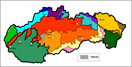 Vtáčnik in Slovakia (gray)
| |
| Country | Slovakia |
| Regions | Trenčín and Banská Bystrica |
| Districts | Prievidza, Partizánske, Žarnovica and Žiar nad Hronom |
| Range coordinates | 48°35′N 18°35′E |
| Parent range | Slovak Central Mountains |
| Borders on | List
|
| Geomorphological units | Vysoký Vtáčnik, Nízky Vtáčnik, Župkovská brázda and Raj |
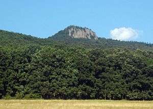
The highest mountain of Vtáčnik
It is bordered in the west, north and northeast by the upper Nitra basin, Strážov Mountains and Žiar, in the east by the Kremnica Mountains and Žiar basin, and in the south by Tribeč and the Štiavnica Mountains.
It is divided further into these geomorphological units:
- Vysoký Vtáčnik ("High Vtáčnik")
- Nízky Vtáčnik ("Low Vtáčnik")
- Župkovská brázda ("Župkov Furrow")
- Raj ("Paradise Mountains")
The four highest mountains are: Vtáčnik (1,346 m), Biela skala (1,136 m), Buchlov (1,040 m), and Žiar (845 m).
Some of the towns or villages around or in Vtáčnik include: Prievidza, Nováky, Handlová, Prochot, Lehota pod Vtáčnikom, and Veľké Pole.
This article is issued from Wikipedia. The text is licensed under Creative Commons - Attribution - Sharealike. Additional terms may apply for the media files.