Świnoujście
Świnoujście [ɕfʲinɔˈui̯ɕt͡ɕɛ] (![]()
Świnoujście | |
|---|---|
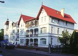
 City panorama | |
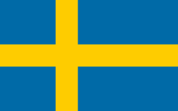
 Flag  Coat of arms | |
 | |
 Świnoujście  Świnoujście | |
| Coordinates: 53°55′N 14°15′E | |
| Country | |
| Voivodeship | |
| County | City County |
| Established | 12th century |
| Town rights | 1765 |
| Government | |
| • Mayor | Janusz Żmurkiewicz |
| Area | |
| • Total | 197.23 km2 (76.15 sq mi) |
| Elevation | 5 m (16 ft) |
| Population (2012) | |
| • Total | 41,516 |
| • Density | 210/km2 (550/sq mi) |
| Time zone | UTC+1 (CET) |
| • Summer (DST) | UTC+2 (CEST) |
| Postal code | 72-600 to 72-612 |
| Area code(s) | +48 091 |
| Car plates | ZSW |
| Climate | Cfb |
| Website | http://www.swinoujscie.pl/ |
Świnoujście directly borders the German seaside resort of Ahlbeck on Usedom, both are freely connected by a street and by 12 km (7 mi) of beach promenade.
Since 1999, Świnoujście has been a city with the administrative rights of a county (powiat) (Polish: miasto na prawach powiatu), within West Pomeranian Voivodeship. It was previously part of Szczecin Voivodeship (1975–1998). The city lies in the geographic region of Pomerania and had a population of 41,516 in 2012. Świnoujście is one of the most important areas of the Szczecin metropolitan region. The Świnoujście LNG terminal opened in 2015 is located in the city.
Despite its relatively small population, Świnoujście is Poland's ninth-largest city by area.
History
The first human settlements, in areas that are now Świnoujście appeared five thousand years ago, as confirmed by archaeological findings. For a thousand years the estuary of the river was part of the state of the Świnoujście who were annexed by Polish ruler Mieszko I. In later centuries local Pomeranian princes ruled the area, and on both sides of the river, they built fortified castles, which were destroyed several times by the Danish invasions in the twelfth century in 1170 and 1173. Between 1185 and 1227 the settlement was part of a Danish fief.
During the Thirty Years' War (1618–1648) the city became part of the Swedish Empire.
The river Świna (German: Swine) was formerly flanked by the fishing villages of Westswine and Ostswine. Towards the beginning of the 17th century it was made navigable for large ships. The Kingdom of Prussia gained the area in 1720 from Sweden, and included it in her Pomeranian province. Swinemünde was founded on the site of Westswine in 1748, fortified, and received town privileges from King Frederick II of Prussia in 1765. It served as the outer port of Stettin (Szczecin) and was administered within the Province of Pomerania. Swinemünde became part of the German Empire after the Kingdom of Prussia completed the unification of Germany in 1871.
The town had broad unpaved streets and one-story houses built in the Dutch style, which gave it an almost rustic appearance, although its industries, beyond some fishing, were entirely connected with its shipping. The river mouth, which was the entrance to the harbor, and which was regarded as the best on the Prussian Baltic coast, was then protected by two curving long breakwaters, and was strongly fortified. On the island of Wollin, on the other side of the narrow Świna, a great lighthouse was erected. In 1897 the canal of the Kaiserfahrt was opened to navigation, and this waterway between the Stettin harbour and the Baltic Sea was deepened between 1900–01. From then on Stettin could be reached directly by ships, and Swinemünde's importance diminished somewhat.
On 12 March 1945 during World War II, refugee-crowded[1][2] Swinemünde suffered heavy destruction by the USAAF, an estimated 5,000[3] to 23,000[4] were killed, most of whom are buried on the Golm War Cemetery west of the town, on the German side of the border. The city and port were also destroyed during the Allied air raids on March 12 and April 16, 1945. The unfinished German aircraft carrier Graf Zeppelin was scuttled in the harbor in an attempt to prevent its capture by the advancing Red Army (it was nevertheless refloated by the Soviets later). The German battleship Schlesien had also participated in the defence of the city, before it too was scuttled. After the German forces defending the city were evacuated, Soviet forces occupied the city on the night of 4–5 May 1945.
After Germany's defeat in the war, the Soviet Union imposed new borders in eastern Europe at the Potsdam Conference, which made Świnoujście a part of Poland. The entire population was forcibly expelled and replaced by ethnic Poles. The Treaty of Zgorzelec signed between the People's Republic of Poland and the German Democratic Republic affirmed the new border, and the German–Polish Border Treaty of 1990 officially affirmed the existing borders after the fall of the Iron Curtain.
In the winter of 1945, some members of the communist Polish Security Forces who had been victims of German concentration camps and other German atrocities acted in revenge against local Germans. An investigation in 2008 estimated that over 40 German civilians were killed. Nine men were charged with the murder and maltreatment of Germans, and in 1947, after one escaped and one hanged himself, seven of them stood trial. The harshest sentence given in that trial was 4 years imprisonment, for theft. In another trial, the town's chief of police, Jan Zientara, was sentenced to eight years, for organizing robberies of German civilians.[5]
In 1948, the reconstruction and reconstruction of the port of Świnoujście from martial to commercial and fishing began. The construction of a large fish farm began, a huge swimming pool and industrial buildings were built, and 3 years later the Fisheries Base was commissioned. Within three years, a large fish factory was established, managed by the independent Przedsiębiorstwo Usług Rybackie Odra in Świnoujście.[5]
It was not until November 27, 1950, that the GDR government agreed to transfer to Poland the water intake for the city of Świnoujście, located at Lake Wolgastsee and demarcating the border there again. In June 1951, an area of 76.5 ha was incorporated into Poland together with a water treatment station, creating a characteristic promontory protruding into the German area (the so-called Worek, (53 54 49.11 N 14 11′11.18 E). In return, Germany was granted a similar area between the water intake and the Pomeranian Bay.
The spa part of the city was occupied by the Soviet Armed Forces until 1957, and until the turn of the 1980s and 1990s, there was a base of Soviet warships with facilities in Świnoujście. Until 1972, the city belonged to the Wolin poviat. In 1959, the "Uzdrowisko Świnoujście" State Enterprise was established. Currently Uzdrowisko Świnoujście S.A. belongs to the largest and most modern in Poland, and its greatest asset is still bromide-iodide-sodium brine discovered a hundred years ago.
In the 1960s and 1970s, a seaport was created, which together with Szczecin created a complex of ports Szczecin-Świnoujście. In 1964, ferry shipping to Scandinavia was resumed.
Geography
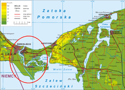
The city is located on the Strait of Świna, which in its northern part connects with the Baltic Sea, and in the south with the Szczecin Lagoon. It is situated on three inhabited islands: Usedom (35,712 inhabitants in 2010), Wolin (4,317 inhabitants), Karsibór (703 inhabitants) and 41 smaller uninhabited islands. Świnoujście is located in the northwestern edge of the province. West Pomeranian (with coordinates 53 ° 54′N 14 ° 14′E). According to data from 1 January 2009, the area of the urban commune is 197.23 km². Every year, the city's area increases by applying sand on the beach by sea currents. Sands settling at the shore caused the shoreline to shift by 1.5 km over the last 200 years. Currently, the beach in the widest section is 200 meters, making the beach in Świnoujście the widest beach in Poland.
Climate
Świnoujscie is situated in the oceanic climate, which is characterized by mild winters and relatively cool summers. A very large influence on the climate of the city is the location of the Baltic Sea. Świnoujscie often in winter is the warmest city in Poland.
| Climate data for Świnoujście | |||||||||||||
|---|---|---|---|---|---|---|---|---|---|---|---|---|---|
| Month | Jan | Feb | Mar | Apr | May | Jun | Jul | Aug | Sep | Oct | Nov | Dec | Year |
| Record high °C (°F) | 13.5 (56.3) |
13.1 (55.6) |
19.7 (67.5) |
25.1 (77.2) |
29.4 (84.9) |
31.8 (89.2) |
34.4 (93.9) |
33.2 (91.8) |
30.2 (86.4) |
24.2 (75.6) |
17.7 (63.9) |
14.6 (58.3) |
34.4 (93.9) |
| Average high °C (°F) | 3.9 (39.0) |
4.2 (39.6) |
8.8 (47.8) |
11.2 (52.2) |
16.9 (62.4) |
19.1 (66.4) |
20.6 (69.1) |
20.1 (68.2) |
16.6 (61.9) |
12.0 (53.6) |
6.2 (43.2) |
4.7 (40.5) |
12.0 (53.6) |
| Daily mean °C (°F) | 0.4 (32.7) |
0.9 (33.6) |
4.5 (40.1) |
8.7 (47.7) |
13.2 (55.8) |
15.8 (60.4) |
17.2 (63.0) |
16.9 (62.4) |
13.9 (57.0) |
9.4 (48.9) |
4.6 (40.3) |
1.7 (35.1) |
8.9 (48.0) |
| Average low °C (°F) | −3.1 (26.4) |
−2.5 (27.5) |
0.1 (32.2) |
6.2 (43.2) |
9.5 (49.1) |
12.5 (54.5) |
13.8 (56.8) |
13.7 (56.7) |
11.2 (52.2) |
6.8 (44.2) |
3.0 (37.4) |
−1.4 (29.5) |
5.8 (42.4) |
| Record low °C (°F) | −22.3 (−8.1) |
−23.6 (−10.5) |
−17.3 (0.9) |
−6.0 (21.2) |
−2.3 (27.9) |
1.0 (33.8) |
4.0 (39.2) |
2.5 (36.5) |
−2.2 (28.0) |
−5.3 (22.5) |
−11.6 (11.1) |
−15.1 (4.8) |
−23.6 (−10.5) |
| Average precipitation mm (inches) | 33 (1.3) |
30 (1.2) |
37 (1.5) |
45 (1.8) |
49 (1.9) |
64 (2.5) |
82 (3.2) |
68 (2.7) |
41 (1.6) |
49 (1.9) |
44 (1.7) |
46 (1.8) |
588 (23.1) |
| Average precipitation days | 17 | 14 | 16 | 12 | 13 | 15 | 16 | 15 | 13 | 16 | 17 | 16 | 180 |
| Average relative humidity (%) | 92 | 90 | 86 | 79 | 80 | 82 | 84 | 85 | 86 | 90 | 91 | 91 | 86 |
| Mean monthly sunshine hours | 38 | 55 | 92 | 147 | 206 | 234 | 223 | 211 | 147 | 96 | 44 | 31 | 1,524 |
| Source 1: www.imigw.pl | |||||||||||||
| Source 2: http://www.stat.gov.pl/cps/rde/xchg/gus | |||||||||||||


Population
- 1875: 7,977[6]
- 1880: 8,478[6]
- 1890: 8,508[6]
- 1900: 10,300
- 1925: 18,352[6]
- 1933: 20,514[6]
- 1939: 26,593[6]
- 1947: 5,800
- 1960: 17,000[7]
- 1970: 28,100[7]
- 1975: 42,400[7] (included Międzyzdroje)
- 1980: 47,100[7]
- 1990: 43,300 (disconnected Międzyzdroje)
- 1995: 43,361[8]
- 2000 - 43 697
- 2001 - 43 351
- 2002 - 41 542
- 2003: 41,188[8]
- 2004: 41,098[8]
- 2005: 40,993[8]
- 2006: 41,100
- 2007 - 40 871
- 2008 - 40 829
- 2009 - 40 765
- 2010 - 40 759
- 2012 - 41 516
Infrastructure


Transport
The town is located on both banks of the river Świna, and since there is no road connection across it, transport is provided by regular ferries. Because the west section is otherwise wholly disconnected from the rest of Poland, this service is free of charge. Under current plans, a road tunnel will be built under the river. The construction contract for it was signed in September 2018, with completion planned for September, 2022.[9]
Świnoujście has the largest and most modern ferry terminal in Poland, with regular connections to Denmark and Sweden. The city lies at the northern terminus of Polish National Route 3 (DK3, in the future express road S3), which is, in turn, part of the European route E65 running across Europe from Sweden to Greece. Świnoujście has four railway stations on the eastern bank of the Świna, on Wolin island, with regular regional connections to Szczecin and long-distance connections to other cities in Poland (e.g. Poznań, Katowice, Bielsko-Biała, Kraków and Warszawa).
Land border controls were abolished 21 December 2007, and free automobile traffic to and from Germany was allowed for the first time since 1945 (when it was part of German territory), as Poland implemented the Schengen Agreement. From 20 September 2008, the city has a railway connection to its western portion as well, when the railway line to Ahlbeck was extended eastward to Świnoujście ("Świnoujście Centrum") giving it a direct link to the German railway network. The nearest airport at Heringsdorf in Germany, 13 kilometres (8 miles) west of Świnoujście, will likely become more important for travelling to the city, if it ever acquires year-round scheduled passenger connections; it currently has a number of summer connections to German cities only. The nearest airport with year-round traffic is the Szczecin-Goleniów "Solidarność" Airport, 80 km (50 mi) to the southeast in Poland.
Tourist attractions
- The former town hall houses the Museum of Deep Sea Fishing. Exhibits include the history of sea fishing, sea animals, the town and its region, and old navigation equipment.
- The Angel's Fort, built from 1845–1858, is a replica of Hadrian's Mausoleum (Castel Sant'Angelo in Rome).
- Concerts and art exhibitions are held at the Western Fort. Built between 1843–1863, it has been modernized a few times in the past. From after World War II until 1962 it was a headquarters of the Red Army.
- The 18th Christ the King Church in the centre of the town was erected on the site of a Gothic temple. A wooden ship replica is in the main nave. Organ concerts are presented during the summer.
- The neo-Gothic church of the Holy Mother "Stella Maris" has stained glass windows of great artistic value. It was erected at the end of the 19th century.
- The "well" is a preserved tower of a Protestant church damaged during World War II and demolished afterwards.
- A shelter built in 1942 has the exposition "The town yesterday and now", presenting pictures of the town's history and other exhibits.
- The Stawa Młyny is a navigation beacon built in the form of a windmill on the 19th century breakwater.
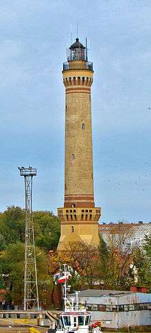
- The lighthouse, built in 1858, is at 68 m the highest lighthouse on the Baltic Sea.
- The Eastern Fort, or Gerhard's Fort, is one of three preserved forts from the 19th century. An exhibition inside the building presents the history of the town's forts, as well as objects found there.
- The district of Karsibór contains an Evangelical cemetery established in the first half of 19th century.
- The Gothic church from the 15th century contains an altar from the 15th century and a pulpit from the 17th century.
- A monument honours the memory of Royal Air Force pilots shot down while raiding the town in April 1945.
- Karsiborska Kępa, an island near the town, contains a bird sanctuary with approximately 140 species.
International relations
Twin towns – Sister cities
Świnoujście is twinned with:


Districts of Świnoujście
- Przytór
- Karsibór
- Wydrzany
- Łunowo
- Ognica
Sports
- Flota Świnoujście – football club that competes in the lower leagues, but from 2008 to 2015 it played in the I liga (second tier)
- Prawobrzeże Świnoujście – football club that competes in the lower leagues
- A weekly free 5 km Parkrun takes place in Świnoujście.
Notable residents


- Alfred Ploetz (1860–1940) a German physician, biologist and eugenicist, coined the term racial hygiene
- Georg Kropp (1865-1943) a German journalist and polymath. He co-founded Germany's first mutual building society
- Elsa von Freytag-Loringhoven (1874–1927) avant-garde, Dadaist artist and poet
- Christel Peters (1916–2009) actress
- Jürgen Harder (1918–1945) a German Luftwaffe fighter ace
- Hans-Werner Grosse (born 1922) record-breaking glider pilot & Luftwaffe pilot
- Gisela Stein (1935–2009) actress
- Hans Jürgen Todt (born 1937) German modern pentathlete, competed at the 1968 Summer Olympics
- Konrad Kwiet (born 1941) a historian and scholar of the Holocaust
- Jerzy Hausner (born 1949) a Polish politician, economist and member of the 4th Sejm
- Andrzej Smolik (born 1970) a Polish musician, composer, music producer and multi-instrumentalist
- Anna Harkowska (born 1980) a Polish cyclist, competed at the 1992 Summer Paralympics as a swimmer, and as a cyclist at the 2012 Summer Paralympics, where she won three silver medals.
- Michał Ruciak (born 1983) a Polish volleyball player, national volleyball team member
Cities and towns near Świnoujście
- Szczecin (Poland)
- Misdroy (Poland)
- Kamień Pomorski (Poland)
- Nowe Warpno (Poland)
- Ueckermünde (Germany)
- Ahlbeck (Germany)
See also
- Dreikaiserbäder (Ahlbeck, Heringsdorf, and Bansin)
- Ports of the Baltic Sea
References
- Torsten Mehlhase, Flüchtlinge und Vertriebene nach dem Zweiten Weltkrieg in Sachsen-Anhalt: ihre Aufnahme und Bestrebungen zur Eingliederung in die Gesellschaft, LIT Verlag Berlin-Hamburg-Münster, 1999, p.256 (ISBN 3-8258-4278-9): 70,000 refugees in Swinemünde on 12 March 1945
- Hanno Ballhausen, Friedemann Bedürftig, Chronik des Zweiten Weltkriegs, wissenmedia Verlag, 2004, p.300 (ISBN 3-577-14367-3): 100,000 people in Swinemünde on 12 March 1945 (refugees+locals)
- Helmut Schnatz, Der Luftangriff auf Swinemünde. Dokumentation einer Tragödie, Herbig 2005, ISBN 3-7766-2393-4
- Christoph Kucklick, Feuersturm. Bombenkrieg gegen Deutschland, Ellert & Richter 2003, ISBN 3-8319-0134-1
- Zadworny, Adam (18 January 2008). "They Were Killing Germans in Revenge". Gazeta Wyborcza. Retrieved 26 June 2019.
- "Deutsche Verwaltungsgeschichte Pommern, Kreis Usedom". Verwaltungsgeschichte.de. Retrieved 12 March 2013.
- Rocznik Statystyczny 1981, Główny Urząd Statystyczny, Warszawa 1981.
- Official website of Świnoujście: O mieście -> Świnoujście w liczbach (in Polish)
- http://tunel-swinoujscie.pl/ Official contract page for tunnel construction
- https://www.parkrun.pl/swinoujscie/
External links
| Wikivoyage has a travel guide for Świnoujście. |
| Wikimedia Commons has media related to Świnoujście. |
- Official website of Świnoujście (in English and Polish)
| City counties |
|  |
|---|---|---|
| Land counties | ||
| Authority control |
|
|---|