Øyer
Øyer is a municipality in Innlandet county, Norway. It is part of the traditional region of Gudbrandsdal. The administrative centre of the municipality is the village of Tingberg.
Øyer kommune | |
|---|---|
 Coat of arms 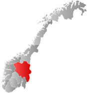 Innlandet within Norway | |
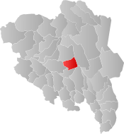 Øyer within Innlandet | |
| Coordinates: 61°15′55″N 10°24′48″E | |
| Country | Norway |
| County | Innlandet |
| District | Gudbrandsdal |
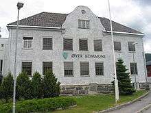
| Administrative centre | Tingberg |
| Government | |
| • Mayor (2007) | Mari Botterud (H) |
| Area | |
| • Total | 640 km2 (250 sq mi) |
| • Land | 616 km2 (238 sq mi) |
| Area rank | 176 in Norway |
| Population (2004) | |
| • Total | 4,870 |
| • Rank | 196 in Norway |
| • Density | 8/km2 (20/sq mi) |
| • Change (10 years) | 3.9% |
| Demonym(s) | Øyværing[1] |
| Time zone | UTC+01:00 (CET) |
| • Summer (DST) | UTC+02:00 (CEST) |
| ISO 3166 code | NO-3440 |
| Official language form | Neutral[2] |
| Website | www |
The parish of Øier was established as a municipality on 1 January 1838 (see formannskapsdistrikt). It is one of very few municipalities in Norway with unchanged borders since that date.
General information
Name
The Old Norse form of the name were Øyja (accusative case and dative case) which comes from the word Øyi (nominative case). Two lakes in Norway had the name Øyi(r) in Norse times (now called Øymark and Øyeren), and these names are derived from the word øy which means "flat and fertile land along the edge of the water". This name is probably given to this area because the Lågen river widens out in the central part of the municipality and creates two river-lakes (called the Jemnefjorden and Gildbusfjorden). Øyi was probably the old name of one (or both) of these "fjords". Prior to 1918, the name was spelled "Øier".[3]
Coat-of-arms
The coat-of-arms is from modern times. They were granted on 29 April 1983. The arms show a silver-colored wooden ring, or hærder, on a green background. It was made of wood and was used to fasten a tree trunk to a rope in order to haul it over the land. Similar devices were used all over Norway, but this shape is typical for the area.[4][5]
| Ancestry | Number |
|---|---|
| 71 | |
| 60 | |
| 55 | |
| 52 | |
| 32 |
History
The Black Death reached Norway in the winter of 1349/50. Øyer was one of the parishes most severely impacted; estimates based on tax payments suggest that between 2/3 and 3/4 of all residents died. Many of the farms there became deserted farmss (øygarder), which remained vacant until the late 17th century. The parish of Tretten was merged into Øyer after the Black Death, because the decimated population of Tretten no longer could maintain their own priest.
Geography
In Oppland, Øyer is bordered by Ringebu municipality to the north, Ringsaker to the southeast, and Lillehammer to the south. To the east lies Stor-Elvdal municipality (located in Hedmark county). The municipality is divided in two parishes: Øyer in the south and Tretten in the north.
Economy
Øyer has traditionally been a farming and logging municipality.
Recreation is increasingly important economically. Since it opened in 1989, Øyer's Hafjell Alpine Ski Center has grown to include 15 lifts (with an additional in construction) and 28 runs as wells as extensive cross-country skiing runs. It is 15 kilometers from Lillehammer, making it very accessible. Tobogganing, luge, and bobsled racing (on the 1994 Olympic course) are also found in the area.
Notable residents
- Simon Johnson (1874–1970), Norwegian-American author
- Erling Jevne (1966- ), skier
- Kjetil Haraldstad (1973- ), member of Satyricon and 1349
- Johannes Skar (1837-1914), folklorist
- Matias Skard (1846-1927), philologist, educator, psalmist, essayist, and translator
Sister cities
The following cities are twinned with Øyer:[7]
References
- "Navn på steder og personer: Innbyggjarnamn" (in Norwegian). Språkrådet.
- "Forskrift om målvedtak i kommunar og fylkeskommunar" (in Norwegian). Lovdata.no.
- Rygh, Oluf (1900). Norske gaardnavne: Kristians amt (in Norwegian) (4 ed.). Kristiania, Norge: W. C. Fabritius & sønners bogtrikkeri. p. 160.
- Norske Kommunevåpen (1990). "Nye kommunevåbener i Norden". Retrieved 2009-01-03.
- "Om Øyer" (in Norwegian). Øyer kommune. Retrieved 2009-01-03.
- "Immigrants and Norwegian-born to immigrant parents, by immigration category, country background and percentages of the population". ssb.no. Archived from the original on 14 July 2017. Retrieved 14 June 2017.
- "Vennskapskommuner" (in Norwegian). Øyer kommune. Retrieved 2009-01-03.
External links
| Wikimedia Commons has media related to Øyer. |
| Look up Øyer in Wiktionary, the free dictionary. |
- Municipal fact sheet from Statistics Norway

- Church Records for those with ancestors from Øyer. Baptisms and deaths between 1671 and 1857. (in Norwegian)
 |  | ||||||||||||||||||||||||||||||||||||
|