Gudbrandsdalslågen
The Gudbrandsdalslågen (or the Lågen) is a river which flows through the valley of Gudbrandsdal in Norway.[1][2]
| Gudbrandsdalslågen | |
|---|---|
 | |
| Physical characteristics | |
| Source | |
| • location | Lesjaskogsvatnet |
| • elevation | 611 m (2,005 ft) |
| Mouth | |
• location | Mjøsa |
• elevation | 123 m (404 ft) |
| Length | 204 km (127 mi) |
Overview
The Gudbrandsdalslågen begins in the lake Lesjaskogsvatnet (or Lesjavatn), which lies in Lesja municipality in Innlandet. Lesjavatn is the only lake in Norway which has two outlets; they flow into two of Norway’s more famous rivers. In the southeast at Lesjaverk village the lake serves as the headwaters for the Gudbrandsdalslågen, while in the northwest at Lesjaskog village, Lesjavatn is the headwaters for the Rauma river.
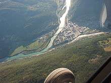
The Gudbrandsdalslågen flows through the Gudbrandsdal. Western tributaries of the Gudbrandsdalslågen include the Gausa River flowing through the Gausdal valley, the Otta River flowing through the Ottadalen valley, the Vinstra River flowing through Vinstradalen, and the Sjoa River, flowing through the Heidal valley. The eastern rivers, Jora, Ula, Frya, Tromsa and Mesna are shorter and drop precipitously from the heights of the Rondane. Although relatively placid for extended stretches of its 200-kilometre (120 mi) path, the Gudbrandsdalslågen drops rapidly through the Rosten Gorge in Sel.[3]
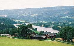
Between the municipalities of Ringebu and Øyer the river widens out and creates the large so-called "riverlake," Losna).
The Gudbrandsdalslågen terminates in the lake of Mjøsa at Lillehammer. It is the largest river flowing into this lake, which discharges into the short Vorma River.[4] The Vorma joins the Glomma River at Nes.[5]
Norwegian rivers crest in the spring as the snow melts. The Gudbrandsdalslågen, draining higher elevations and being primarily glacier fed, typically crests later than the Glomma river, which drains the east valleys. In the rare year when both crest at the same time, their confluence at Nes is the site of great floods. The most famous simultaneous crest of the Gudbrandsdalslågen and Glomma resulted in the flood of 20–23 July 1789, with crests over 50 feet above mean level at Lake Øyer below Nes and extensive damage, including 68 casualties.
Etymology
Lågen is the finite form of låg (Old Norse lǫgr m) 'water; river'. The meaning is just 'the river', and this term must have replaced an old name that is now forgotten and unknown. (Compare with Numedalslågen.)[6]
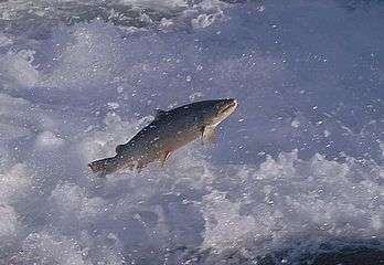 Hundertrout spawning[7]
References and notes
- Lars Mæhlum. "Gudbrandsdalslågen". Store norske leksikon. Retrieved January 1, 2017.
- The word lågen means watercourse in the Norwegian language and appears as a suffix meaning river. Examples of this use include in Gudbrandsdalslågen, Numedalslågen, and Suldalslågen. Lågen is commonly used for each in their traditional district.
- Lars Mæhlum. "Gausa". Store norske leksikon. Retrieved January 1, 2017.
- The names of Norwegian rivers are not everywhere consistent along the watercourse, instead reflecting historical usage.
- Geir Thorsnæs. "Glomma". Store norske leksikon. Retrieved January 1, 2017.
- Børge Nordbø. "Lågen". Store norske leksikon. Retrieved January 1, 2017.
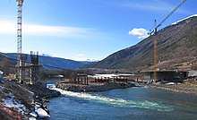
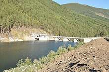
- The Hunder trout Archived 2015-09-17 at Archive.today is bred at the Hunderfossen waterfall on the Gudbrandsdalslågen river, by the 280m long power station dam. Next to the dam, there is an outdoor exhibition centre for hunder trout. There is a hatchery on the west bank; it produces 20,000 hunder trout every year and releases them into the river to compensate for the loss of fish and of spawning grounds when the power plant was established.
Related reading
- East Norway and its Frontier by Frank Noel Stagg, George Allen and Unvin, Ltd., 1956.
- Adventure Roads in Norway by Erling Welle-Strand, Nortrabooks, 1996. ISBN 82-90103-71-9
- Scandinavia, An Introductory Geography by Brian Fullerton & Alan Williams, Praeger Publishers, 1972.
See also
- Populated places on the Gudbrandsdalslågen river (category)