Zhovti Vody
| Zhovti Vody Жовті Води | |||
|---|---|---|---|
 Zhovti Vody Palace of Culture | |||
| |||
 Zhovti Vody Location of Zhovti Vody | |||
| Coordinates: 48°21′0″N 33°30′0″E / 48.35000°N 33.50000°E | |||
| Country |
| ||
| Oblast |
| ||
| Raion | Zhovti Vody City Municipality | ||
| Founded | 1895 | ||
| City | 1957 | ||
| Area | |||
| • Total | 33.25 km2 (12.84 sq mi) | ||
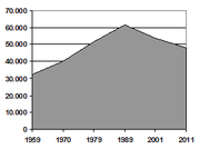
| Population (2013) | |||
| • Total | 47,509 | ||
| • Density | 1,588/km2 (4,110/sq mi) | ||
| Postal code | 52290- | ||
| Area code(s) | +380-5652 | ||
| Website |
zhv | ||


Zhovti Vody (Ukrainian: Жовті Води, Ukrainian pronunciation: [ˈʒɔwtʲi ˈwɔdɪ]; Russian: Жёлтые Воды, Russian pronunciation: [ˈʐoltɨjə ˈvodɨ], lit. Yellow Waters) is a town in south-central Ukraine's Dnipropetrovsk Oblast (province). Administratively, it is incorporated within Zhovti Vody municipality as a town of oblast significance, the status equivalent to that of a raion (district). Zhovti Vody is located on the Yellow River (Ukrainian: Річка Жовта) approximately 130 km (81 mi) west of the oblast's administrative center, Dnipro. Population: 47,509 (2013 est.)[1].
It is a center for the extraction and processing of uranium ore.
The historic Battle of Zhovti Vody was fought on the site of the present-day city.
The area has been referred to by the term Zhovti Vody (literally "yellow waters") since before the founding of the first village on the site in 1895.
Demographics
Sport
There's a bandy team.
Gallery
 Bus station
 Mining plant building
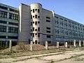 Former factory in Zhovti Vody
 "Nova" mine
 Main street
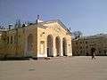 Zhovti Vody Old Town
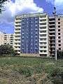 New building in Zhovti Vody
.JPG) Zhovta River
Zhovta River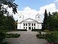 Old Orthodox church
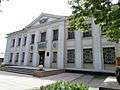 Zhovti Vody Museum of History
 Children's park
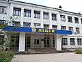 Zhovti Vody Lycaeum
 Apartment blocks in Zhovti Vody
 Institute of Business Strategy
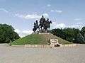 Liberation War monument
Famous People
- Inna Tsyganok, a professional russian triathlete
- Anastasia Polyanskaya, a professional russian triathlete
References
- ↑ "Чисельність наявного населення України (Actual population of Ukraine)" (in Ukrainian). State Statistics Service of Ukraine. Retrieved 21 January 2015.
External links
| Wikimedia Commons has media related to Zhovti Vody. |
- (in Russian) Zhovti Vody News
- (in Ukrainian) Information Card of the City - official site of the Parliament of Ukraine
| Raions | |||||
|---|---|---|---|---|---|
| Cities |
| ||||
| |||||