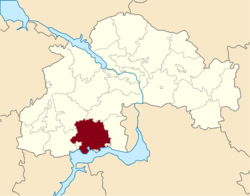
Nikopol Raion
| Nikopol Raion Нікопольський район | |||
|---|---|---|---|
| Raion | |||
| |||
 | |||
| Coordinates: 47°37′23″N 34°31′57.6″E / 47.62306°N 34.532667°ECoordinates: 47°37′23″N 34°31′57.6″E / 47.62306°N 34.532667°E | |||
| Country |
| ||
| Region | Dnipropetrovsk Oblast | ||
| Admin. center | Nikopol | ||
| Subdivisions |
List
| ||
| Area | |||
| • Total | 1,943 km2 (750 sq mi) | ||
| Population | |||
| • Total | 42 189 | ||
| Time zone | UTC+2 (EET) | ||
| • Summer (DST) | UTC+3 (EEST) | ||
| Area code | +380 | ||

Nikopol Raion (Ukrainian: Нікопольський район, Nikopolskyi raion) is an administrative subdivision (raion) of Dnipropetrovsk Oblast, Ukraine, with the administrative center in the city of Nikopol. Its territory is 1,940 km2. (second largest among the raions). Population: 42,189 (2013 est.)[1].
Within its territory, in addition to its capital of Nikopol, there are 68 settlements subordinated to it, of which 63 villages, 4 minor rural-type settlements[2] and 1 urban-type settlement (Chervonohryhorivka).[3] Nikopol itself is incorporated separately as a city of oblast significance and does not belong to the raion.
The southern border of the raion is by the Kakhovka Reservoir by the Dnieper River.
References
- ↑ "Чисельність наявного населення України (Actual population of Ukraine)" (in Ukrainian). State Statistics Service of Ukraine. Retrieved 21 January 2015.
- ↑ The Ukrainian term is selishche (uk:Селище), usually refers to a khutor, fisherman settlement or dacha settlement
- ↑ A record of the district and the Ukrainian government website
| Raions | |||||
|---|---|---|---|---|---|
| Cities |
| ||||
| |||||
This article is issued from
Wikipedia.
The text is licensed under Creative Commons - Attribution - Sharealike.
Additional terms may apply for the media files.