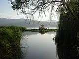
Zrebar Lake
| Lake Zrêbar زریوار Zrewar | |
|---|---|
| Location |
Zagros Mountains, Kurdistan Province, Iran |
| Coordinates | 35°32′N 46°08′E / 35.533°N 46.133°ECoordinates: 35°32′N 46°08′E / 35.533°N 46.133°E |
| Primary outflows | Zrêbar River |
| Basin countries | Iran |
| Max. length | 5 km (3.1 mi) |
| Max. width | 1.6 km (0.99 mi) |
| Max. depth | 6 m (20 ft) |
| Water volume | 30×106 m3 (24,000 acre⋅ft) |
| Surface elevation | 1,285 m (4,216 ft) |
| Settlements | Marivan |
Lake Zrebar , also known as Zeribar or Zrewar (Kurdish: Zrêbar or Zrêwar, زرێبار), (Persian: زریوار Zarivār), is a lake in the Zagros Mountains, within Kurdistan Province of western Iran.
Etymology
The name is composed of zrê ("sea") and the suffix -bar (which in Kurdish means "lake").
Situation
The lake is situated in the Iranian province of Kordestan west of Marivan and has a length of 5 km (3.1 mi) and a maximum width of 1.6 km (0.99 mi). The lake's water is fresh and has a maximum depth of 6 metres (20 ft).
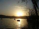
Zeribar Lake is a major touristic attraction in the region.[1] There is a great deal of folklore about the origins of this lake amongst the Kurdish people of the area.
Gallery


References
- ↑ SBB/MMN (Jan 11, 2008). "Cold hits Iran mythological landmark" (web). News Article. PressTV. Retrieved September 3, 2010.
External links
| Capital | 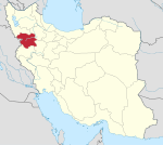 | ||||||||||||||||||||
|---|---|---|---|---|---|---|---|---|---|---|---|---|---|---|---|---|---|---|---|---|---|
| Counties and cities |
| ||||||||||||||||||||
| Sights |
| ||||||||||||||||||||
| populated places | |||||||||||||||||||||
This article is issued from
Wikipedia.
The text is licensed under Creative Commons - Attribution - Sharealike.
Additional terms may apply for the media files.