Yosemite, Kentucky
| Yosemite | |
|---|---|
| Unincorporated community | |
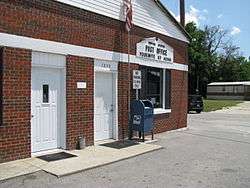 Post office in Yosemite, Kentucky | |
 Yosemite Location within the state of Kentucky  Yosemite Yosemite (the US) | |
| Coordinates: 37°20′48″N 84°49′29″W / 37.34667°N 84.82472°WCoordinates: 37°20′48″N 84°49′29″W / 37.34667°N 84.82472°W | |
| Country | United States |
| State | Kentucky |
| County | Casey |
| Elevation | 840 ft (260 m) |
| Time zone | UTC-5 (Eastern (EST)) |
| • Summer (DST) | UTC-4 (EST) |
| ZIP codes | 42566 |
| GNIS feature ID | 507236[1] |
Yosemite is an unincorporated community in eastern Casey County, Kentucky, United States. Their Post Office was closed in September 2011.[2] It was established in the 1870s for logging facilities owned by Cincinnati businessman Eugene Zimmerman. It was named by his daughter, who said the hilly area reminded her of the Yosemite valley in California.
References
- ↑ U.S. Geological Survey Geographic Names Information System: Yosemite, Kentucky
- ↑ http://webpmt.usps.gov/pmt007.cfm. Retrieved July 30, 2012. Missing or empty
|title=(help)
Municipalities and communities of Casey County, Kentucky, United States | ||
|---|---|---|
| City | 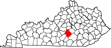 | |
| Unincorporated Communities | ||
| Ghost Town | ||
This article is issued from
Wikipedia.
The text is licensed under Creative Commons - Attribution - Sharealike.
Additional terms may apply for the media files.