Dogwood, Casey County, Kentucky
| Dogwood | |
|---|---|
| Unincorporated community | |
 Dogwood Location within the state of Kentucky  Dogwood Dogwood (the US) | |
| Coordinates: 37°25′49″N 84°56′48″W / 37.43028°N 84.94667°WCoordinates: 37°25′49″N 84°56′48″W / 37.43028°N 84.94667°W | |
| Country | United States |
| State | Kentucky |
| County | Casey |
| Elevation | 1,280 ft (390 m) |
| Time zone | UTC-6 (Central (CST)) |
| • Summer (DST) | UTC-5 (CST) |
| GNIS feature ID | 2568366[1] |
Dogwood was an unincorporated community in Casey County, Kentucky, United States.
References
Municipalities and communities of Casey County, Kentucky, United States | ||
|---|---|---|
| City | 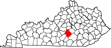 | |
| Unincorporated Communities | ||
| Ghost Town | ||
This article is issued from
Wikipedia.
The text is licensed under Creative Commons - Attribution - Sharealike.
Additional terms may apply for the media files.