Yobe State
| Yobe | ||
|---|---|---|
| State | ||
| État de Yobe | ||
| ||
| Nickname(s): Pride of the Sahel | ||
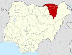 Location of Yobe State in Nigeria | ||
| Coordinates: 12°00′N 11°30′E / 12.000°N 11.500°ECoordinates: 12°00′N 11°30′E / 12.000°N 11.500°E | ||
| Country |
| |
| Date created | 27 August 1991 | |
| Capital | Damaturu | |
| Government | ||
| • Governor (List) | Ibrahim Geidam (APC) | |
| • Deputy Governor | Abubakar Ali | |
| • Senators |
| |
| Area | ||
| • Total | 45,502 km2 (17,568 sq mi) | |
| Area rank | 6th of 36 | |
| Population (2006 census) | ||
| • Total | 2,321,339[1] | |
| • Estimate (2011) |
2,757,000 | |
| • Rank | 32nd of 36 | |
| GDP (PPP) | ||
| • Year | 2007 | |
| • Total | $2.01 billion[2] | |
| • Per capita | $843[2] | |
| Time zone | UTC+01 (WAT) | |
| ISO 3166 code | NG-YO | |
Yobe is a state located in Northeast Nigeria. A mainly agricultural state, it was created on August 27, 1991. Yobe state was carved out of Borno State. The capital of Yobe state is Damaturu.
Geography
The state borders the Nigerian states of Bauchi, Borno, Gombe, and Jigawa. It borders the Diffa Region and the Zinder Region to the north in the Republic of Niger. Because the state lies mainly in the dry savanna belt, conditions are hot and dry for most of the year, except in the southern part of the state which has a milder climate.
History
Yobe State came into being on 27 August 1991. It was carved out of the old Borno State by the Babangida administration. Yobe State was created because the old Borno State was one of Nigeria's largest states in terms of land area and was therefore considered to be too large for easy administration and meaningful development. Ethnic rivalries within the old Borno State also contributed to the decision.[3]
On 14 May 2013, President Goodluck Jonathan declared a state of emergency in Yobe State along with neighboring Borno State and Adamawa State, due to the activities of the terrorist network Boko Haram. Abubakar Shekau, the leader of Boko Haram, was born in Shekau village of Yobe.[4]
Local government areas
Yobe State consists of 17 local government areas (or LGAs). They are:
Economy
While Yobe state is an agricultural state it also has rich fishing grounds and mineral deposits of gypsum in Fune LGA, kaolin, and quartz. The state's agricultural products include gum arabic, groundnuts, beans, and cotton. The state is also said to have one of the largest cattle markets in West Africa, located in Potiskum.
Ethnic groups
The major ethnic group living in Yobe State are Fulani, while other ethnic communities include Ngizim, Karai-Karai, Bolewa, Bade, Hausa, Ngamo, Shuwa, Fulani Bura, Margi and Maga.
Religion
The population is mainly Muslim. Sharia law is valid. However, there are Christians in the State, with the bulk of them from the Karai-Karai ethnic group. No Roman Catholic diocese has its seat in the state.
References
- ↑ "2006 PHC Priority Tables – NATIONAL POPULATION COMMISSION". population.gov.ng. Retrieved 2017-10-10.
- 1 2 "C-GIDD (Canback Global Income Distribution Database)". Canback Dangel. Retrieved 2008-08-20.
- ↑ "Yobe State", Online Nigeria, Accessed here on 3 August 2007.
- ↑ "Nigeria declares 'massive' military campaign on borders". BBC News. 15 May 2013. Retrieved 6 June 2013.