Kaduna State
| Kaduna State | ||
|---|---|---|
| State | ||
| ||
| Nickname(s): Centre of Learning | ||
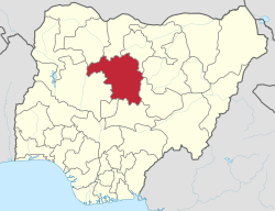 Location of Kaduna State in Nigeria | ||
| Coordinates: 10°20′N 7°45′E / 10.333°N 7.750°ECoordinates: 10°20′N 7°45′E / 10.333°N 7.750°E | ||
| Country |
| |
| Date created | 27 May 1967 | |
| Capital | Kaduna | |
| Government | ||
| • Governor (List) | Mallam Nasir Ahmad el-Rufai (All Progressives Congress) | |
| • Deputy Governor | Yusuf Barnabas Bala | |
| • Senators |
| |
| Area | ||
| • Total | 46,053 km2 (17,781 sq mi) | |
| Area rank | 4th of 36 | |
| Population (2006 census)1 | ||
| • Total | 6,113,503[1] | |
| • Rank | 3rd of 36 | |
| GDP (PPP) | ||
| • Year | 2007 | |
| • Total | $13.33 billion[2] | |
| • Per capita | $1,666[2] | |
| Time zone | UTC+01 (WAT) | |
| ISO 3166 code | NG-KD | |
| Website | ||
| ^1 Preliminary results | ||
Kaduna, usually referred to as Kaduna State to distinguish it from the city of Kaduna, is a state in Northwest Nigeria. Its capital is Kaduna.
Geography
The state is located at the Northern part of Nigeria's High Plains. The vegetation cover is Sudan Savannah type, characterized by scattered short trees, shrubs and grasses. The soil is mostly loamy to sandy type. A substantial amount of clay is found also.
History
The word Kaduna is said to be a corruption of a Gbagyi word/name for a river. Another version of the etymology of the name is a narrative linked to the Hausa word for crocodile - but this is contested by the Gbagyi people known to have lived in the area for centuries. It is therefore indicative that the name, Kaduna, was taken up by Lord Frederick Lugard and his colonial colleagues when they moved the capital of the then Northern Region from Zungeru to Kaduna in 1916. This move of the colonial office to Kaduna started in 1912-1918/20 with the initial effort having been made in 1902 from Jebba to Zungeru.
At the start of British colonial rule in northern Nigeria the people groups who live in the area became 'Northern Nigerians'- a construct which continues even today. By 1967 these people groups again were carved into 'North Central State'; this was the case until 1975 that 'Kaduna State' was formerly created by the then military leader, Gen. Murtala Mohammed, with all distinct identities amalgamated into one state without a referendum. The state hence is the successor of the old Northern Region of Nigeria, which had its capital at Kaduna which is now the state capital to about 6.3 million people (Nigerian census figure, 2006).
In 1967, the old Northern Region was divided into six states in the north, leaving Kaduna as the capital of North-Central State, whose name was changed to Kaduna State in 1976. Meanwhile, Kaduna State was further divided in 1987, creating Katsina State. Under the governance of Kaduna are the ancient cities of Zaria, Kafanchan, and Nok, the area where Africa's earliest civilization is recorded to have been excavated. The most intriguing aspect of this area is that the colonial construction and its post-colonial successor called 'Nigeria' hardly documented the history or the method of how Kaduna state's people groups encompassed in these constructs define and identify themselves as such the people groups who populate the area have lived in near oblivion or obscurity as they often are thought of as Hausa people.
The current governor of Kaduna state is Mallam Nasir el-Rufa'i.
Local Government Areas
Kaduna State consists of twenty-three (23) Local Government Areas. They are:
Demographics
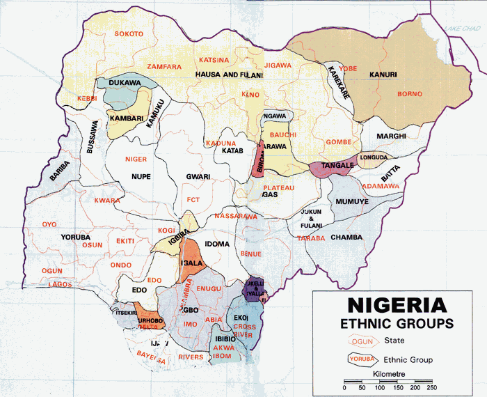
Kaduna State, north central Nigeria, is politically classified as belonging to the now 'North - West' zone of the current six Geo - political zones of Nigeria. It is populated by about 59 to 63 different ethnic groups, if not more, with the exactitude of the number requiring further verification through genuine field work [Hayab, 2014]. The question as in the last paragraph with the Hausa and Fulani as the dominant ethnic groups followed by at least 60 others. These groups include:
- Adara (dubbed Kadara)
- Akurmi (labelled Kurama by the Hausa)
- Anghan (dubbed Kamanton by the Hausa)
- Amo
- Aruruma (named Ruruma by the Hausa)
- Atachaat (dubbed Kachechere)
- Atyab (dubbed Kataf by the Hausa)
- Ayu
- Bajju (dubbed Kaje by the Hausa)
- Bakulu (Ikulu by the Hausa)
- Bhazar (named Koro)
- Bur (Sanga)
- Binawa
- Dingi
- Fantswam
- Fulfulde
- Gbagyi (Gwari in Hausa)
- Gure
- Gwandara
- Gwong (Kagoma in Hausa)
- Ham (dubbed Jaba in Hausa, which is a derogatory name)
- Hausa
- Jangi (dubbed Gwari by the Hausa)
- Kaibi
- Kahugu
- Kanufi
- Kigono
- Kinugu
- Kitimi
- Kiwafa
- Kiwollo
- Koro
- Kuvori (called Surubu)
- Kuturmi
- Lemoro * not sure
- Mada (Mardan) Mada must have migrated during colonial rule
- Nandu
- Nduyah
- Numana
- Nindem
- Ningeshe
- Ninkyop
- Ninzo
- Nyenkpa (Yeskwa)
- Oegworok
- Pikal
- Pitti
- Ribang
- Rishuwa
- Rumada
- Ruruma
- Rumayya
- Shemawa * Hausa name?
- Sholio (Dubbed Marwa)
- Siyawa (Bauchi state?)
- Takad, (Attakar)
- Tarri
- Tsam (Chawai)
- Tuku (Atuku by the Hausa)
Available records show that Christian mission activities in the area began formally in the 1900s with the establishment of Sudan Interior Mission (S.I.M.) in the Ham town of Har Kwain (Kwoi), hence today these people groups are Mainly Christians. Culturally, the people groups of the then southern Zaria who are now Southern Kaduna, with some exception it must be acknowledged, share a lot in the cultural practices of marriage rites, naming, burial, farming, social organisations, kinship, etc. Until full scale research is undertaken, the diversity of Kaduna state remains blurred as some ethnic groups are so small in population that they are often overshadowed by the larger groups who live near them.[3]
Education
Kaduna is one of the education centers in Nigeria, with many colleges and the most recognized university in Nigeria
- Nigerian Defence Academy
- Ahmadu Bello University, Zaria
- Nuhu Bamalli Polytechnic, Zaria
- Kaduna State University
- Federal Polytechnic, Kaduna
- Nigerian College of Aviation Technology, Zaria
- College of Education Gidan Waya-Kafanchan
- Shehu Idris College of Health Health Sciences And Technology-Makarfi
- College of Nursing-Kafanchan
- Institute of Leather Research-Zaria
- Federal College of Education, Zaria
- National Open University of Nigeria
- National Water Resources Institute, Kaduna
- Nigerian Institute of transport technology, Zaria
- National Teachers Institute, Kaduna
- School of Midwifery Kaduna
- National Institute For Hospitality and Tourism.
Health
Kaduna State has over 1,000 primary healthcare facilities to cater to every resident - even in the most remote village or ward of the state. To further improve on healthcare delivery, in 2016, the Kaduna State Government partnered with the UK Department For International Development (DFID) to install over 1.3MW of Solar Systems in primary healthcare facilities across the state.[4]
References
- ↑ "2006 PHC Priority Tables – NATIONAL POPULATION COMMISSION". population.gov.ng. Retrieved 2017-10-10.
- 1 2 "C-GIDD (Canback Global Income Distribution Database)". Canback Dangel. Retrieved 2008-08-20.
- ↑ http://www.onlinenigeria.com/map.gif
- ↑ "Energy | Kaduna State Government". www.kdsg.gov.ng. Retrieved 2017-05-02.