Yamacraw, Kentucky
| Yamacraw | |
|---|---|
| Unincorporated community | |
 Yamacraw Location within the state of Kentucky  Yamacraw Yamacraw (the US) | |
| Coordinates: 36°43′1″N 84°32′15″W / 36.71694°N 84.53750°WCoordinates: 36°43′1″N 84°32′15″W / 36.71694°N 84.53750°W | |
| Country | United States |
| State | Kentucky |
| County | McCreary |
| Elevation | 994 ft (303 m) |
| Time zone | UTC-6 (Central (CST)) |
| • Summer (DST) | UTC-5 (CST) |
| GNIS feature ID | 516499[1] |
Yamacraw is an unincorporated community and coal town in McCreary County, Kentucky, United States. It was also known as Big South Fork. Their post office closed in 1950.[2]
References
Municipalities and communities of McCreary County, Kentucky, United States | ||
|---|---|---|
| CDPs | 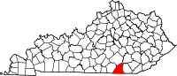 | |
| Unincorporated communities | ||
This article is issued from
Wikipedia.
The text is licensed under Creative Commons - Attribution - Sharealike.
Additional terms may apply for the media files.