Marshes Siding, Kentucky
| Marshes Siding | |
|---|---|
| Unincorporated community | |
 Marshes Siding Location within the state of Kentucky  Marshes Siding Marshes Siding (the US) | |
| Coordinates: 36°44′37″N 84°28′51″W / 36.74361°N 84.48083°WCoordinates: 36°44′37″N 84°28′51″W / 36.74361°N 84.48083°W | |
| Country | United States |
| State | Kentucky |
| County | McCreary |
| Elevation | 1,329 ft (405 m) |
| Time zone | UTC-5 (Eastern (EST)) |
| • Summer (DST) | UTC-4 (EDT) |
| ZIP codes | 42631 |
| GNIS feature ID | 513799[1] |
Marshes Siding is an unincorporated community within McCreary County, Kentucky, United States.
References
Municipalities and communities of McCreary County, Kentucky, United States | ||
|---|---|---|
| CDPs | 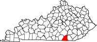 | |
| Unincorporated communities | ||
This article is issued from
Wikipedia.
The text is licensed under Creative Commons - Attribution - Sharealike.
Additional terms may apply for the media files.