Yadagiri
| Yadgir Yadgiri | |
|---|---|
| city | |
 Yadgir Location in Karnataka, India | |
| Coordinates: 16°46′N 77°08′E / 16.77°N 77.13°ECoordinates: 16°46′N 77°08′E / 16.77°N 77.13°E | |
| Country |
|
| State | Karnataka |
| Region | Hyderabad-Karnataka |
| District | Yadgir district |
| Lok Sabha Constituency | Raichur (Lok Sabha constituency) |
| Area | |
| • Total | 5.6 km2 (2.2 sq mi) |
| Elevation | 389 m (1,276 ft) |
| Population (2011)[1] | |
| • Total | 74,294 |
| • Density | 10,500.36/km2 (27,195.8/sq mi) |
| Languages | |
| • Official | Kannada |
| Time zone | UTC+5:30 (IST) |
| PIN | 585201 / 585202 |
| Telephone code | 08473 |
| Vehicle registration | KA-33 |
| Website | www.yadgircity.mrc.gov.in |
Yadgir is a city and the administrative headquarters of Yadgir district in the Indian state of Karnataka. It is also the administrative headquarters of Yadgir Taluku, one of the three talukas of the district.
Geography
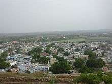
The town covers an area of 5.6 square kilometres (2.2 sq mi).[2] The Bhima River flows through Yadgir town.
Overview
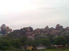
Yadgir, historically known as Yetagiri,[3] it is dotted with many historical monuments and has a hill fort with three rounds of fortifications. There are three ancient temples, medieval mosques, tanks and wells on top of the hill. A tank, the Sanna Kere is located in the heart of the town.
Demographics
In 2011, Yadgir had population of 1,172,985 of which male and female were 591,104 and 581,881 respectively. In the 2001 census, Yadgir had a population of 956,180 of which males were 482,347 and remaining 473,933 were females. Yadgir District population constituted 1.92 percent of total Karnataka population. In 2001 census, this figure for Yadgir District was at 1.81 percent of Karnataka population.
There was change of 22.67 percent in the population compared to population as per 2001. In the previous census of India 2001, Yadgir District recorded increase of 20.12 percent to its population compared to 1991.
The initial provisional data released by census India 2011, shows that density of Yadgir district for 2011 is 224 people per km2. In 2001, Yadgir district density was at 183 people per km2. Yadgir district administers 5,225 square kilometers of areas.
Average literacy rate of Yadgir in 2011 were 52.36 compared to 39.90 of 2001. If things are looked out at gender wise, male and female literacy were 63.33 and 41.31 respectively. For 2001 census, same figures stood at 51.35 and 28.32 in Yadgir District. Total literate in Yadgir District were 516,940 of which male and female were 313,797 and 203,143 respectively. In 2001, Yadgir District had 310,614 in its district.
Culture and religion
In Yadgir several spiritual places are located like Mayllapur Mallayya. The temple of Sri Kshetra Mouneshwar Temple Tinthani in Shorapur Taluka the temple attracts more than hundred thousand devotees every year. In Gurmitakal Mata Manikeshawri Yadgir is one of the spiritual heritage. The sofi sarmast durga is in Shahapur taluka village called sagar. The durga attracts thousands of people in the urus of sofi sarmast, Darga Shah Jeewan Shah Which is Located Near Gunj Area Yadgir. A function hall named Moghal Garden Function Hall is situated near Sedam Road.
Irrigation
Agriculture in the district mainly depends upon the rainfall and the net area irrigated to net area sown is 38%, which is above the state average of 24%. Krishna, Bhima and Dhoni rivers flow in the district. The medium irrigation projects in the district are Hattikuni and Soudha ghar. There are 36 lift irrigation schemes and 445 minor irrigation tanks in the district.
History
The town was part of the empire of the Western Chalukyas from the 10th to 12th centuries. The name Yadgir (historically Yetagiri[3]) is derived from its early medieval rulers, 'Yadavas', who ruled with their establishments on a mountain known as 'giri' in Kannada. Yadavs from the present-day Andhra Pradesh. A major economic development of the city took place under Philip Meadows Taylor, the administrator of the principality of Shorapur.
Transport
Yadgir is connected by road and railways.
- Railway
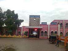
Yadgir has its own railway station.[5] It has the broad gauge railway which lies between Mumbai and Chennai. It comes under South Central Railway under Guntakaldivision. It has its own railway branch. The city is connected to Gulbarga, 78 KM away, by Railway and by Road is 84 KM . And from Raichur its distance is 81 km. It is actually located in between two districts.[6]
- Road
State Highway 15 passes through the city connecting to Bijapur and Hyderabad. Important cities connected through buses from the city are Bangalore, Hubli, Dharwad, Belgaum, Sirsi, Hospet, Vasco da Gama, Hyderabad, Bellary, Raichur.[7]
Industry
Yadgiri is place of full natural resource like water (Mainly Two river flows Krishna and Bhima) and there is lots of scope for Industrilisation in future. One Sugar and fuel industry "Core Green" also established near Hiretumkur village. [8] Recently Rich uranium deposits have been found in the Gogi belt covering the villages of Gogi, Ukkinal, Darshanapur in Shahapur taluk, and Thinthini and other places in Surapur taluk. Uranium processed here will be used for defence and power generation purpose.
References
- ↑ http://www.censusindia.gov.in/pca/SearchDetails.aspx?Id=666255
- ↑ "Population of Corporation/CMC/TMC/TP: Population 2001 Census". Directorate of Municipal Administration, Government of Karnataka. Archived from the original on 10 April 2009.
- 1 2 "A strong hold on the past". Retrieved 2011-01-07.
- ↑ http://www.census2011.co.in/census/district/270-yadgir.html
- ↑ "Yadgir District Map Showing Railway Line". Yadgir District.
- ↑ "Yadgir railway station plays it cool". www.thehindu.com. Retrieved 8 October 2017.
- ↑ "NEKRTC Yadgir Division". www.nekrtc.com. Retrieved 8 October 2017.
- ↑ Srinivas Sirnoorkar (May 13, 2010). "India's third uranium mining unit at Gogi". Deccan Herald.
External links
| Wikimedia Commons has media related to Yadgir. |
District HQ: Yadgir | |||||||
| Cities and towns | |||||||
| Villages and other settlements |
| ||||||
| Parks, reserves and places of interest | |||||||