Wray, Colorado
| Wray, Colorado | |
|---|---|
| City | |
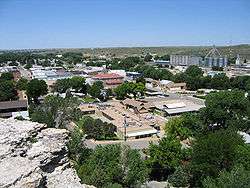 Wray in 2004 | |
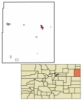 Location of Wray in Yuma County, Colorado. | |
| Coordinates: 40°4′36″N 102°13′33″W / 40.07667°N 102.22583°WCoordinates: 40°4′36″N 102°13′33″W / 40.07667°N 102.22583°W | |
| Country | United States |
| State | Colorado |
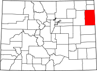
| County[1] | Yuma County - seat[2] |
| Incorporated | June 22, 1906[3] |
| Government | |
| • Type | Home Rule Municipality[1] |
| • City Manager | Stan Holmes[4] |
| Area[5] | |
| • Total | 3.44 sq mi (8.91 km2) |
| • Land | 3.44 sq mi (8.90 km2) |
| • Water | 0.00 sq mi (0.01 km2) |
| Elevation[6] | 3,566 ft (1,087 m) |
| Population (2010) | |
| • Total | 2,342 |
| • Estimate (2016)[7] | 2,367 |
| • Density | 688.48/sq mi (265.85/km2) |
| Time zone | UTC-7 (MST) |
| • Summer (DST) | UTC-6 (MDT) |
| ZIP code | 80758[4][8] |
| Area code(s) | 970[4] |
| FIPS code | 08-86310 |
| GNIS feature ID | 0183032 |
| Website | wrayco.net |
Wray (/ˈreɪ/) is a Home Rule Municipality that is the county seat of Yuma County, Colorado, United States.[2][9] Located in the Colorado Plains, the city is 170 miles east of Denver, 9 miles west of the Nebraska state line, and 25 miles northwest of the Kansas state line. The population was 2,342 at the U.S. Census 2010.[10]
History
A post office called Wray has been in operation since 1882.[11] The community was named after John Wray, a cattleman.[12]
Wray was named an "All-America City" in 1993 by the National Civic League.[13]
Geography
Wray is located at 40°4′36″N 102°13′33″W / 40.07667°N 102.22583°W (40.076721, -102.225873),[14] near the intersection of U.S. Highway 34 and U.S. Highway 385. According to the United States Census Bureau, the city has a total area of 3.0 square miles (7.8 km2), all land.
Climate
Wray has a semi-arid continental climate.
| Climate data for Wray, Colorado | |||||||||||||
|---|---|---|---|---|---|---|---|---|---|---|---|---|---|
| Month | Jan | Feb | Mar | Apr | May | Jun | Jul | Aug | Sep | Oct | Nov | Dec | Year |
| Record high °F (°C) | 80 (27) |
80 (27) |
88 (31) |
94 (34) |
103 (39) |
110 (43) |
112 (44) |
109 (43) |
104 (40) |
96 (36) |
90 (32) |
78 (26) |
112 (44) |
| Average high °F (°C) | 43 (6) |
48 (9) |
56 (13) |
65 (18) |
74 (23) |
85 (29) |
91 (33) |
89 (32) |
81 (27) |
70 (21) |
52 (11) |
44 (7) |
67 (19) |
| Average low °F (°C) | 11 (−12) |
17 (−8) |
23 (−5) |
32 (0) |
44 (7) |
54 (12) |
60 (16) |
57 (14) |
47 (8) |
33 (1) |
21 (−6) |
14 (−10) |
34 (1) |
| Record low °F (°C) | −27 (−33) |
−30 (−34) |
−24 (−31) |
−5 (−21) |
21 (−6) |
25 (−4) |
39 (4) |
30 (−1) |
18 (−8) |
3 (−16) |
−15 (−26) |
−33 (−36) |
−33 (−36) |
| Average precipitation inches (mm) | 0.51 (13) |
0.41 (10.4) |
1.16 (29.5) |
1.17 (29.7) |
3.02 (76.7) |
2.56 (65) |
2.91 (73.9) |
1.97 (50) |
1.13 (28.7) |
0.99 (25.1) |
0.75 (19) |
0.36 (9.1) |
16.94 (430.3) |
| Average snowfall inches (cm) | 5.5 (14) |
2.9 (7.4) |
7.2 (18.3) |
2.9 (7.4) |
0.1 (0.3) |
0 (0) |
0 (0) |
0 (0) |
0.1 (0.3) |
1.5 (3.8) |
4.1 (10.4) |
4.3 (10.9) |
28.6 (72.6) |
| Source: [15] | |||||||||||||
Demographics
| Historical population | |||
|---|---|---|---|
| Census | Pop. | %± | |
| 1890 | 125 | — | |
| 1900 | 271 | 116.8% | |
| 1910 | 1,000 | 269.0% | |
| 1920 | 1,538 | 53.8% | |
| 1930 | 1,785 | 16.1% | |
| 1940 | 2,061 | 15.5% | |
| 1950 | 2,198 | 6.6% | |
| 1960 | 2,082 | −5.3% | |
| 1970 | 1,953 | −6.2% | |
| 1980 | 2,131 | 9.1% | |
| 1990 | 1,998 | −6.2% | |
| 2000 | 2,187 | 9.5% | |
| 2010 | 2,342 | 7.1% | |
| Est. 2016 | 2,367 | [7] | 1.1% |
| U.S. Decennial Census[16] | |||
As of the census[17] of 2000, there were 2,187 people, 888 households, and 547 families residing in the city. The population density was 739.6 people per square mile (285.3/km²). There were 968 housing units at an average density of 327.4 per square mile (126.3/km²). The racial makeup of the city was 94.42% White, 0.09% African American, 0.27% Native American, 0.09% Asian, 3.48% from other races, and 1.65% from two or more races. Hispanic or Latino of any race were 10.01% of the population.
There were 888 households out of which 30.3% had children under the age of 18 living with them, 51.9% were married couples living together, 7.8% had a female householder with no husband present, and 38.3% were non-families. 35.1% of all households were made up of individuals and 18.5% had someone living alone who was 65 years of age or older. The average household size was 2.38 and the average family size was 3.11.
In the city, the population was spread out with 26.7% under the age of 18, 7.0% from 18 to 24, 24.6% from 25 to 44, 21.3% from 45 to 64, and 20.3% who were 65 years of age or older. The median age was 39 years. For every 100 females, there were 88.7 males. For every 100 females age 18 and over, there were 85.1 males.
The median income for a household in the city was $29,052, and the median income for a family was $38,942. Males had a median income of $26,847 versus $19,250 for females. The per capita income for the city was $16,547. About 11.3% of families and 14.5% of the population were below the poverty line, including 14.8% of those under age 18 and 14.5% of those age 65 or over.
Education
The school mascot is the Eagles for high school and Eaglets in the lower grades. School colors are purple and white and the Eaglets were blue and white but were changed to purple and white to match the high school in 2011.
Health care
The town and surrounding area are served by the Wray Community District Hospital.
See also
References
- 1 2 "Active Colorado Municipalities". State of Colorado, Department of Local Affairs. Archived from the original on 2010-11-23. Retrieved 2007-09-01.
- 1 2 "Colorado County Seats". State of Colorado, Department of Public Health and Environment. Retrieved 2007-12-31.
- ↑ "Colorado Municipal Incorporations". State of Colorado, Department of Personnel & Administration, Colorado State Archives. 2004-12-01. Retrieved 2007-09-02.
- 1 2 3 "City Hall". Wray, Colorado. Retrieved 2007-08-17.
- ↑ "2016 U.S. Gazetteer Files". United States Census Bureau. Retrieved Jul 25, 2017.
- ↑ "US Board on Geographic Names". United States Geological Survey. 2007-10-25. Retrieved 2008-01-31.
- 1 2 "Population and Housing Unit Estimates". Retrieved June 9, 2017.
- ↑ "ZIP Code Lookup". United States Postal Service. August 18, 2007. Archived from the original (JavaScript/HTML) on November 23, 2010. Retrieved August 18, 2007.
- ↑ "Find a County". National Association of Counties. Retrieved 2011-06-07.
- ↑ "2010 City Population and Housing Occupancy Status". U.S. Census Bureau. Retrieved June 7, 2012.
- ↑ "Post offices". Jim Forte Postal History. Retrieved 11 July 2016.
- ↑ Dawson, John Frank. Place names in Colorado: why 700 communities were so named, 150 of Spanish or Indian origin. Denver, CO: The J. Frank Dawson Publishing Co. p. 52.
- ↑ http://www.ncl.org/index.php?option=com_content&view=article&id=130&Itemid=186
- ↑ "US Gazetteer files: 2010, 2000, and 1990". United States Census Bureau. 2011-02-12. Retrieved 2011-04-23.
- ↑ http://www.intellicast.com/Local/History.aspx?location=USCO0419
- ↑ "Census of Population and Housing". Census.gov. Retrieved June 4, 2015.
- ↑ "American FactFinder". United States Census Bureau. Retrieved 2008-01-31.