Hale, Colorado
| Hale, Colorado | |
|---|---|
| Unincorporated community | |
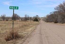 County Road LL.5 in Hale, looking north. | |
| Coordinates: 39°37′50″N 102°08′37″W / 39.63056°N 102.14361°WCoordinates: 39°37′50″N 102°08′37″W / 39.63056°N 102.14361°W | |
| Country |
|
| State |
|
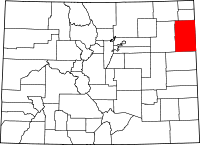
| Counties | Yuma[1] |
| Elevation[1] | 3,602 ft (1,098 m) |
| Time zone | UTC-7 (MST) |
| • Summer (DST) | UTC-6 (MDT) |
| ZIP code[2] | 80735 (Idalia) |
Hale is an unincorporated community in Yuma County, Colorado, United States located along US 36. The U.S. Post Office at Idalia (ZIP Code 80735) now serves Hale postal addresses.[2]
Geography
Hale is located at 39°37′50″N 102°08′37″W / 39.63056°N 102.14361°W (39.630548,-102.143497).
References
- 1 2 "US Board on Geographic Names". United States Geological Survey. 2007-10-25. Retrieved 2008-01-31.
- 1 2 "ZIP Code Lookup". United States Postal Service. January 3, 2007. Archived from the original (JavaScript/HTML) on November 23, 2010. Retrieved January 3, 2007.
This article is issued from
Wikipedia.
The text is licensed under Creative Commons - Attribution - Sharealike.
Additional terms may apply for the media files.