Wormeldange
| Wormeldange Wuermeldeng | ||
|---|---|---|
| Commune | ||
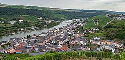 Wormeldange seen from the nearby chapel Koeppchen | ||
| ||
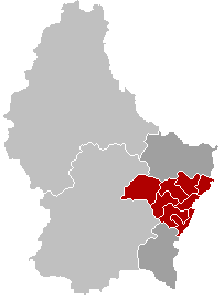
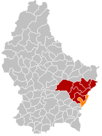 Map of Luxembourg with Wormeldange highlighted in orange, and the canton in dark red | ||
| Coordinates: 49°36′40″N 6°24′20″E / 49.6111°N 6.4056°ECoordinates: 49°36′40″N 6°24′20″E / 49.6111°N 6.4056°E | ||
| Country |
| |
| Canton | Grevenmacher | |
| Government | ||
| • Mayor | Jean Beining | |
| Area | ||
| • Total | 17.25 km2 (6.66 sq mi) | |
| Area rank | 70 of 102 | |
| Highest elevation | 355 m (1,165 ft) | |
| • Rank | 85th of 102 | |
| Lowest elevation | 137 m (449 ft) | |
| • Rank | 3rd of 102 | |
| Population (2014) | ||
| • Total | 2,523 | |
| • Rank | 52nd of 102 | |
| • Density | 150/km2 (380/sq mi) | |
| • Density rank | 47th of 102 | |
| Time zone | UTC+1 (CET) | |
| • Summer (DST) | UTC+2 (CEST) | |
| LAU 2 | LU00007008 | |
| Website | wormeldange.lu | |

Wormeldange (Luxembourgish: Wuermeldeng, German: Wormeldingen) is a commune and small town in eastern Luxembourg. It is part of the canton of Grevenmacher, which is part of the district of Grevenmacher.
As of 2005, the town of Wormeldange, which lies in the south of the commune, has a population of 742. Other towns within the commune include Ahn, Ehnen, Machtum, and Wormeldange-Haut.
External links

Places adjacent to Wormeldange | ||||||||||
|---|---|---|---|---|---|---|---|---|---|---|
| ||||||||||
 | ||
This article is issued from
Wikipedia.
The text is licensed under Creative Commons - Attribution - Sharealike.
Additional terms may apply for the media files.